
Three pains we hear from collateral-evaluation teams
Evidence for collateral is scattered
Street-line prices live at the National Tax Agency, official land prices at MLIT, hazard maps on each municipality's portal, registry data at the legal affairs bureau. Just rotating between counters and hand-matching the data eats half a day to a full day.
Out-of-area underwriting depends on personal experience
For properties outside the bank's home turf, staff fall back on individual area knowledge. Gathering land-price trends and recent comparables takes 2 to 3 days, and the difficulty of standardising breeds quality variance in underwriting.
Hazard risks easily slip through
Floods, landslides, tsunami, and geology each live on their own portal. Collateral-time checks are person-dependent, which tends to create internal-control gaps.
What changes after MAPRISE
| Scenario | Before | After (MAPRISE) |
|---|---|---|
| Collateral investigation | Manually gather street-line / land / hazard from many sites (half a day +) | All data unified on one screen; AI drafts the evaluation comment |
| Out-of-area market analysis | Call local branches; outsource market research (2–3 days) | 19 years of land-price trends + recent comparables in seconds |
| Mid-loan monitoring | Staff periodically re-check each portal manually | Hazard changes and land-price moves for registered properties auto-alerted (planned) |
| Emergency lending post-disaster | Days to assess damage; rapid lending hard | All collateral properties listed on the hazard map; impact known immediately |
| Credit-committee writeup | Manual comment-writing across multiple sources | AI integrates land-price, risk, and market trend into a draft comment |
The Before / After above shows the workflow improvements MAPRISE aims to deliver (estimates); actual results vary by environment and usage.
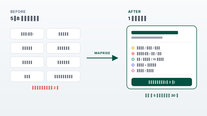
From rotating street-line, land-price, hazard, and registry counters to a single MAPRISE screen
Four capabilities built for financial institutions
Collateral data hub
Street-line / official land prices, transaction history, registry map, hazard, geology — all on a single screen. Aims to cut investigation time by up to 80% (estimated) and standardise evaluation quality.
Note: the registry map data does not constitute official certification by the Legal Affairs Bureau. For formal verification of rights, please obtain a certified copy of the registry.
AI credit-committee comment drafting
The AI integrates land-price trend, risk score, and surrounding market into a draft credit-committee comment. Staff confirm and edit — execution becomes review-only.
19-year land-price timeline
Visualise official and survey land-prices for 2007–2025 on a time-series chart. Attach the area's trend and rate-of-change as evidence directly to the credit-committee package.
Mid-loan monitoring alerts (planned)
A planned capability: hazard changes and land-price moves around mid-loan collateral detected automatically and sent by email — making FSA monitoring compliance more efficient.
A reshaped day for the collateral-evaluation desk
| Time | MAPRISE step | Duration |
|---|---|---|
| 9:00 | Corporate client submits a loan application; collateral and certificate confirmed | Intake |
| 9:15 | Enter the address → street-line / hazard / geology / registry / land-price trend all on one screen | Few minutes |
| 10:00 | Click "Generate AI credit-committee comment" → draft in ~3 minutes | ~3 min |
| 10:30 | Confirm and edit the AI comment (professional judgement stays with the analyst) | ~20 min |
| 11:00 | Finalise the credit-committee package with the land-price chart PDF attached | — |
| Ongoing | Mid-loan monitoring: land-price moves and hazard changes auto-alerted (planned) | Automatic |
What used to take 2 days is targeted to finish in a single morning (estimated impact; actual results vary by usage).
Data backdrop for regional banks & shinkin
(See the four hero statistics above.)
Frequently asked questions
Q. Can the credit-committee template be customised?
A. Yes — on the Business plan, output layouts can be customised to match in-house formats. The Enterprise plan (coming soon, timing TBD) will also include one-on-one work with our CSM.
Q. How is security and information handling structured?
A. Hosted on AWS with TLS encryption end-to-end. The property information you input is not shared with other tenants. SSO/SAML support is planned for the Enterprise plan.
Q. Is on-premises deployment supported?
A. Today we offer cloud (SaaS) only. We can discuss dedicated environments under the Enterprise plan.
Q. Can it integrate with our existing lending systems via API?
A. API-key based integration with external systems is planned. Specific requirements are scoped under the Enterprise plan.
Q. What does mid-loan monitoring notification cover?
A. Email alerts covering hazard-info changes and land-price moves around registered properties are planned (Business / Enterprise). Integration with flood and landslide warnings is also on the roadmap.
Recommended plan
For collateral evaluation across a regional bank or shinkin, we recommend the Business plan.
- Shared workspace for up to 10 branch staff (planned)
- Optional "Powered by" badge removal
- API integration (planned); 3-year history retention
- Up to 5,000 property registrations / portfolio entries
See it in the real app
Use case: for collateral valuation and loan screening, AI quantifies how disaster risk affects land prices, and an overall risk score plus investment verdict strengthens credit memos.


Analysis results are for reference only. Consult a licensed real-estate agent or specialist before any contract or investment decision.