Research time
Before
3 days
After MAPRISE
3 hours
1/8
Integrate zoning, hazards, land prices, and frontage in one click — auto-generate DD reports with AI.
Rooted in Kyushu. Powered by AI.
* Time savings and impact figures on this site are targets MAPRISE aims to deliver (estimates); actual results vary by usage.
An illustrative comparison of the old workflow against MAPRISE across 9 key metrics. These are projected improvements that MAPRISE aims to deliver, to be validated through upcoming pilot deployments.
* All workflow improvement metrics on this site are projected improvements that MAPRISE aims to deliver. Actual results may vary depending on implementation and usage. * Compared with the lower bound of published Pro-tier prices of conventional commercial GIS products (as of June 2026, based on our own research).
Zoning, hazards, land value, and AI reports — switch between tabs to see each capability.
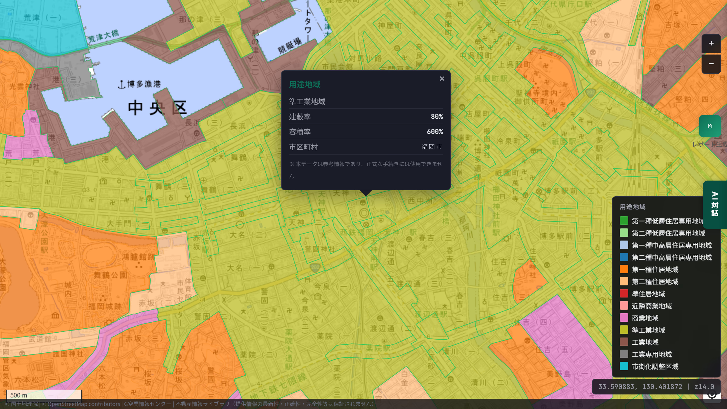
Instant city-plan overlays — zoning, BCR, and FAR in 3 seconds.
Feature in depth
Every screen below is the live MAPRISE app (maprise.jp) — not a concept, but a product running in production right now.


Hazard maps, aerial photos, zoning, land prices — information you used to chase across separate sites, now compared at once in one place. A capability virtually unmatched among domestic services.
Sources: MLIT National Land Numerical Information (zoning, fire-prevention districts) / GSI (aerial imagery)


What was here before? Reclaimed land, or a former wetland? Line up five eras of aerial photos and historical maps to read a site’s origins and risks in a few clicks.
Sources: GSI (aerial photos, historical maps) / MLIT National Land Numerical Information (flood-control landform classification, land conditions)


“How do disaster risk and land prices relate around here?” — ask, and in seconds it aggregates the data and presents a conclusion alongside a chart. Every answer is computed from real data, structurally suppressing plausible-sounding hallucinations.
Sources: MLIT Real Estate Information Library (land prices, transactions) / National Land Numerical Information (hazards, facilities)
Analysis results are for reference only. Consult a licensed real-estate agent or specialist before any contract or investment decision.


Just pick from 12 analysis menus. Pull regulations, land prices, hazards, and future population for a single property, then auto-generate a PDF with an overall risk score and investment verdict — ranging from a minimal set to around 20 pages, depending on the selected items.
Sources: MLIT PLATEAU / AIST Seamless Geological Map / e-Stat / National Land Numerical Information
Analysis results are for reference only. Consult a licensed real-estate agent or specialist before any contract or investment decision.
WHAT'S NEW
Recent releases, expansions, event participations and press coverage — up to the latest five.
Five industry-specific workflows aiming to cut research time by up to 95%. *Estimated impact; actual results vary by usage.
Cut disclosure-statement research from 2-3 days to 30 minutes (estimated).
Complete property DD and investment review on a single screen.
Validate collateral valuation directly on the map.
Pre-check appraisal reports, registry maps & land history on one screen.
Unified GIS data for urban planning and disaster preparedness.
WHY KYUSHU NOW
Semiconductor investment, rising land prices, and inbound tourism recovery are all converging on Kyushu. MAPRISE is the shortest path to ride this tailwind through real-estate operations DX.
Boosted by ¥23T semiconductor ripple + 5M inbound visitors
10-year cumulative economic ripple effect (by region)
Actual cumulative investment: approx. ¥481.2B (as of March 2025)
* Kumamoto: 2022–2031 cumulative / Kyushu region: 2021–2030 cumulative
Source: Kumamoto Pref. — Kyushu Financial Group (Regional Economic Research Institute), Sep 2024 / Kyushu-Okinawa-Yamaguchi — Kyushu Economic Research Center, Dec 2024KERC#1 and #2 nationwide (2024 standard land prices, commercial use)
TSMC-driven semiconductor investment driving land prices up
Source: MLIT Standard Land Prices 2024Foreign visitor arrivals to Kyushu
+~8% vs 2019 / Tourism spending ¥3.27T (2024)
Source: MLIT Kyushu Transport Bureau (Mar 2025) / Japan Tourism Agency / Kyushu Tourism OrganizationTransparent pricing for scaling DD work across Kyushu. Annual billing gives you 2 months free.
For evaluation
Solo / side projects
Most popular for SMBs
Mid-sized teams and branch sharing
Custom requirements — coming soon (timing TBD). Contact us
All prices exclude tax. Pro and above are planned for application as eligible tools under the "デジタル化・AI導入補助金 2026" (Digital and AI Adoption Subsidy operated by SMRJ; standard 1/2 subsidy rate). Enterprise is coming soon (timing TBD). Contact us to discuss requirements.
See exactly what each plan includes.
← Scroll horizontally to see all plans. →
| Plan comparison | Free | Starter | Pro | Business | Enterprise |
|---|---|---|---|---|---|
| GIS & Map | |||||
| Base map & aerial imagery | Yes | Yes | Yes | Yes | Yes |
| Split-screen view | 2 panes | 4 panes | 4 panes | 4 panes | 4 panes |
| All hazard layers | Top 3 | Yes | Yes | Yes | Yes |
| Land price points | Last 3 yrs | 10 yrs | 10 yrs | All | All |
| Transaction prices | Color only | 10 yrs | 10 yrs | All | All |
| Coverage / FAR values | — | Yes | Yes | Yes | Yes |
| PLATEAU 3D attributes | — | Yes | Yes | Yes | Yes |
| Property appraisal reports | — | — | Beta (map view) | Beta (map view) | Beta (map view) |
| Update notifications | On release | On release + email (planned) | On release + email (planned) | + team broadcast (planned) | + API webhook (planned) |
| AI & Analysis | |||||
| Monthly AI credits | 50 | 500 | 2,000 | 10,000 | Unlimited* |
| Natural-language map control | — | — | Yes | Yes | Yes |
| Area comparison | — | — | Up to 5 | Unlimited | Unlimited |
| AI legal Q&A | — | Top 5 topics | All 8 topics | All 8 topics | + custom topics |
| Reports & Business | |||||
| Simple PDF reports | Preview | 3/mo | 20/mo | 100/mo | Unlimited |
| Detailed PDF reports | — | — | 10/mo | 50/mo | Unlimited |
| White-label branding | — | — | Logo upload | Hide Powered-by | Full custom |
| Property portfolio | — | — | 100 | 5,000 | 20,000 + CSV bulk (planned) |
| AI history retention | Starter and up | 30 days | 6 mo | 3 yrs | Unlimited + Export |
| Export formats | — | CSV (planned) | CSV / GeoJSON (planned) | CSV / GeoJSON / SHP (planned) | All + bulk API (planned) |
| Team & Integrations | |||||
| Included seats (multi-seat access is rolling out — currently via a primary account plus additional seats on request) | 1 | 1 | 3 | 10 | Unlimited |
| Team workspace | — | — | — | Planned | Planned |
| SSO / SAML | — | — | — | — | Planned |
| Support | Community | Email + Chat | Dedicated CSM | ||
| Multi-language UI | JA / EN | JA / EN | JA / EN | JA / EN | + on request |
* Credits are shared across all features; listed counts are maximums when used alone.
Still have questions? Email info@maprise.jp anytime.
From the 5-second Hero pitch to Pricing — thank you for sticking with us. Take the next step with the free plan or a Pro trial; either works.
No credit card required. 30 seconds to start, cancel anytime.
* During the beta, sign up and try Pro-level features right away — no waiting. Monthly AI-credit limits and storage features follow the Free plan.