Of everything we've expanded nationwide, the Registry Office cadastral maps (parcel boundaries) and the PLATEAU 3D city model were by far the heaviest datasets. Here's why they matter, a little about how we shipped them, and how we plan to live with data that never truly finishes.
Hello from the MAPRISE team. In our last post, we wrote about a single day spent expanding layers from Kyushu's 7 prefectures to all 47. This time, we're covering the two datasets that were the heaviest part of that nationwide push — Registry Office cadastral maps (parcel boundaries) and the PLATEAU 3D city model — and what it took to get through them over the Obon holiday.
From Kyushu's 7 prefectures to the whole country — two peaks left standing
MAPRISE started out covering Fukuoka, Saga, Nagasaki, Kumamoto, Oita, Miyazaki, and Kagoshima. As we expanded nationwide, most statistical and facility layers came together relatively quickly. What remained until the end were these two datasets — heaviest both in raw size and in how complex they were to process.
1. Registry Office cadastral maps (parcel boundaries)
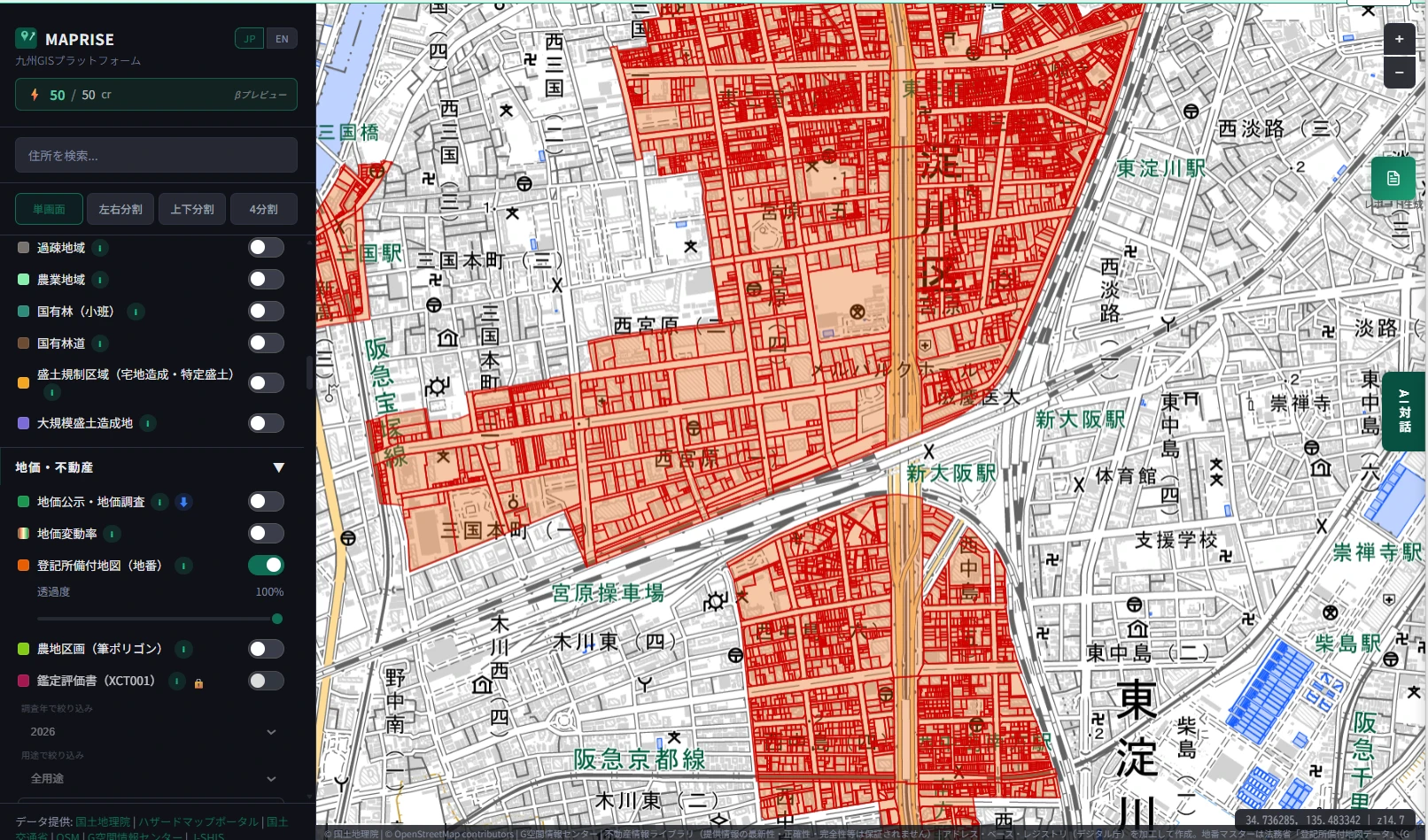
Japan's Legal Affairs Bureaus maintain cadastral maps that show the boundaries of every individual land parcel (地番). This data underpins essentially every real estate registration and transaction, but until now it's been genuinely hard to view in bulk — you'd typically need to visit a Legal Affairs Bureau counter or pay for a commercial map data service.
By making parcel boundaries viewable directly in MAPRISE, we let you see exactly which block and parcel number a given piece of land belongs to — something a plain address or map view can't tell you — layered right alongside land price, statistical, and hazard data. For real estate, finance, and municipal work that touches property rights, this is a particularly high-value dataset.
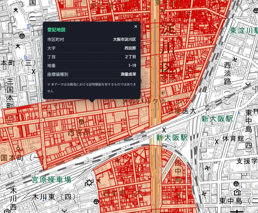
Clicking a parcel polygon brings up a popup with details: municipality, district (大字), block (丁目), parcel number (地番), and coordinate type.
2. PLATEAU 3D city model
The Ministry of Land, Infrastructure, Transport and Tourism's Project PLATEAU turns building position, height, and usage data for cities across Japan into a 3D city model. We've covered how to use the building layer and filling in unknown-use buildings before — this was another dataset we'd only rolled out in Kyushu until now.
We've been expanding building data ingestion nationwide, and as of this writing MAPRISE has 23,759,999 buildings across 265 municipalities loaded in. Overlaying an entire city's shape in 3D lets you read building-level information — sunlight, streetscape, seismic standards — right alongside land prices and statistical data, in a way that's genuinely spatial.
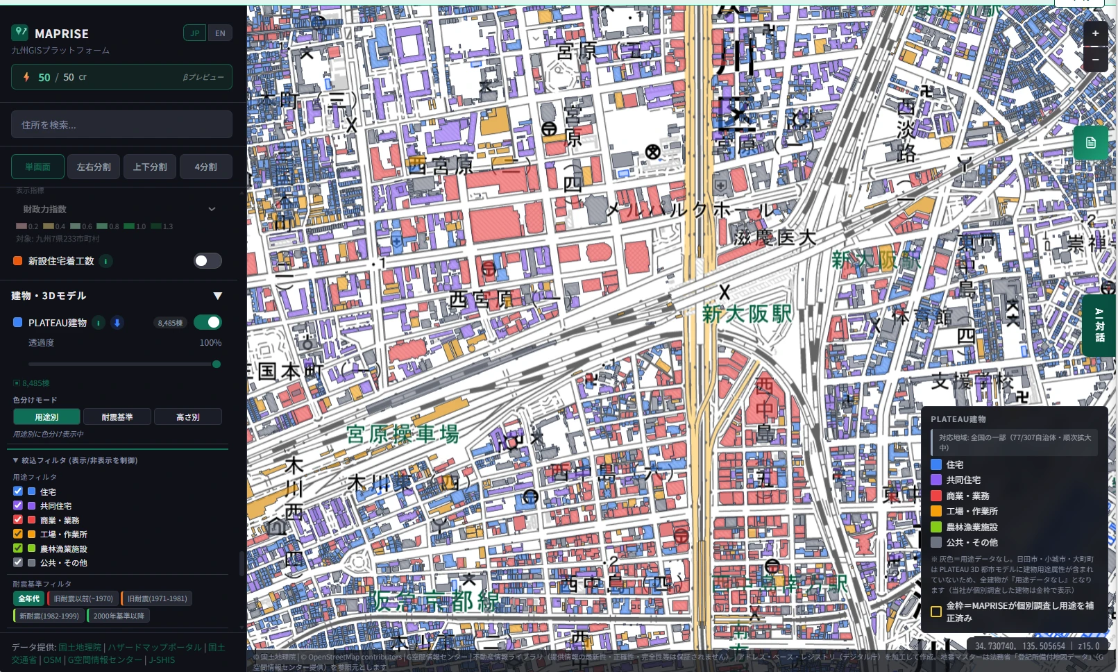
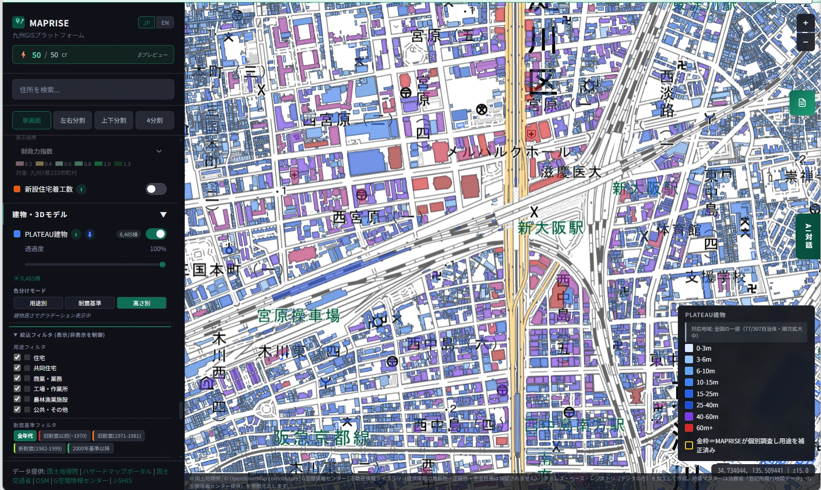
The two PLATEAU screenshots above were taken while the nationwide ingestion was still in progress. The municipality count shown in the legend is a snapshot from that moment and may not match the 265-municipality figure stated in the body of this post.
A little about how we shipped this
Both the cadastral maps and PLATEAU data vary in format and granularity from one prefecture or municipality to the next. The approach we used for Kyushu's 7 prefectures — checking each region individually — simply doesn't scale to 47 prefectures and hundreds of municipalities.
So for this rollout, we pushed as much of that per-municipality variance handling as possible into the pipeline itself, so most cases no longer need manual, one-by-one adjustment. We're keeping the specifics under wraps here, since they touch on things we'd rather not disclose competitively, but the shift is from "check and ingest one municipality at a time by hand" to "ingest in bulk, and have a person look only at the outliers."
These datasets never truly finish
Neither the cadastral maps nor PLATEAU is a "load it once and you're done" dataset, for two reasons.
First, coverage itself is still incomplete. PLATEAU currently has 265 municipalities' worth of buildings loaded, but Japan has far more municipalities than that, and plenty of areas are still untouched. The same is true for cadastral maps — the covered area keeps expanding.
Second, even the areas we do cover today aren't static. Parcels get split and merged; buildings get built, demolished, and renovated constantly. Data that's accurate today will have drifted somewhat six months from now. In other words, the job isn't "finish the dataset" — the job is "keep chasing the current state of the world," indefinitely.
Designing for zero-touch maintenance
Keeping up with that kind of never-ending update work by throwing more manual effort at it isn't realistic. So at MAPRISE, we design the update mechanism itself to require as little human intervention as possible.
Honestly, this was close to our first real nationwide pass, so we're squarely in the "growing pains" phase — hitting some municipality-specific quirk we hadn't anticipated, and stopping to fix it, over and over. But turning that process into a pipeline as we go means future updates like this one will be able to run automatically while the team is asleep. The pain this time is also the groundwork for that.
Why we moved the timeline up
We originally planned to roll cadastral maps and PLATEAU out nationwide next year, spending around six months gradually moving from western to eastern Japan. Instead, we decided speed mattered more than polish — better to move fast and imperfect than slow and careful — and pushed forward, updating one layer after another.
Getting through these two datasets — the heaviest and most complex part of the whole nationwide rollout, in both scale and processing complexity — during this Obon holiday is something the team is genuinely proud of.
Closing
The cadastral maps and PLATEAU data covered here are among the heaviest datasets MAPRISE handles, and by nature, they never truly finish. That's exactly why we're investing in mechanisms that can keep themselves up to date without constant hands-on work. There are still areas we haven't covered and accuracy we want to improve, but we'll keep chipping away at it.
Questions or feedback? Reach us any time at info@maprise.jp.
The Registry Office cadastral map data referenced in this post is sourced from information maintained and published by Japan's Ministry of Justice. PLATEAU building data is sourced from the 3D city model maintained by the Ministry of Land, Infrastructure, Transport and Tourism (license: CC BY 4.0). Building and municipality counts reflect this post's publish date and will continue to change as ingestion work progresses.
Tags: #Nationwide expansion #PLATEAU #Cadastral map #Data quality #Data updates
Other-language share text (exception cases)
Quick share above follows our platform-locked language policy (X-family in Japanese, LinkedIn in English). The four panes below let you grab the opposite-language body when needed — e.g. introducing an English post to a Japanese audience on X, or posting a Japanese article to LinkedIn in Japanese. Each pane offers both a copy button and a direct intent link.
📝 登記所備付地図とPLATEAU ― 全国対応でいちばん重かった2つのデータを、お盆に超えた
MAPRISEの全国対応の中でも、登記所備付地図(地番)とPLATEAU 3D都市モデルは群を抜いて重いデータでした。この2つを組み込む意味と、展開にあたっての工夫、そして「一生完成しない」データとどう付き合っていくかを書き残します。
https://maprise.jp/ja/blog/heaviest-nationwide-data/ #全国展開 #PLATEAU
🆕 新しいブログ記事を公開しました。

《登記所備付地図とPLATEAU ― 全国対応でいちばん重かった2つのデータを、お盆に超えた》

MAPRISEの全国対応の中でも、登記所備付地図(地番)とPLATEAU 3D都市モデルは群を抜いて重いデータでした。この2つを組み込む意味と、展開にあたっての工夫、そして「一生完成しない」データとどう付き合っていくかを書き残します。

👉 詳しくはこちら: https://maprise.jp/ja/blog/heaviest-nationwide-data/

#PLATEAU
📝 Registry Cadastral Maps and PLATEAU — Clearing the Two Heaviest Datasets of Our Nationwide Rollout, During Obon
Of everything we've expanded nationwide, the Registry Office cadastral maps (parcel boundaries) and the PLA…
https://maprise.jp/en/blog/heaviest-nationwide-data/ #Nationwideexpansion #PLATEAU
🆕 New on the MAPRISE blog.

《Registry Cadastral Maps and PLATEAU — Clearing the Two Heaviest Datasets of Our Nationwide Rollout, During Obon》

Of everything we've expanded nationwide, the Registry Office cadastral maps (parcel boundaries) and the PLATEAU 3D city model were by far the heaviest datasets. Here's why they matter, a little about how we shipped them, and how we plan to live with data that never truly finishes.

👉 Read the full post: https://maprise.jp/en/blog/heaviest-nationwide-data/

#Nationwideexpansion #PLATEAU #Cadastralmap #Dataquality #Dataupdates