By combining PLATEAU 3D buildings, GSI elevation data and the heights of elevated roads and railways, MAPRISE reproduces shadows at the winter solstice, equinox and summer solstice, hour by hour. A daily sunlight-hours heatmap makes it a handy first check for land acquisition.
Hello from the MAPRISE team. This time we're introducing the "Sun & Shadow" feature, which reproduces the shadows of buildings and mountains on the map so you can see how much sunlight each piece of land receives.
When you're evaluating a site, questions like "how much sun does this land get on a winter afternoon?" or "how far does the shadow of the high-rise to the south reach?" are not easy to answer even with a site visit, because you can't easily compare seasons and times of day. This feature computes shadows from 3D city models and elevation data according to the position of the sun, and lets you compare the winter solstice, equinox and summer solstice hour by hour, right on the map.
What you can do
- Switch between the winter solstice, equinox and summer solstice. Drag the time slider from sunrise to sunset and the shadows follow. The "Play the day" button animates how the shadows move.
- Show a heatmap of daily sunlight hours. For each location, the map color-codes how many hours of sun it receives over the chosen day.
- Include buildings, mountains and elevated structures together. Buildings use PLATEAU heights, mountains and hills use GSI (Geospatial Information Authority of Japan) elevation data, and elevated roads and railways use OpenStreetMap information.
- Click any point to compare all three seasons.
Calculations run in your browser, so you get results right away as you move the map.
How different the seasons are
Even at the same place and time, shadow length changes dramatically with the season. Here are the shadows around Osaka Station at 15:00 in each of the three seasons.
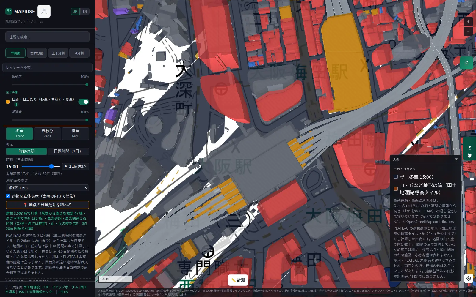
At 15:00 on the winter solstice, the sun is just 17.4° high and shadows stretch long. You can see that much of the station forecourt is in shade.
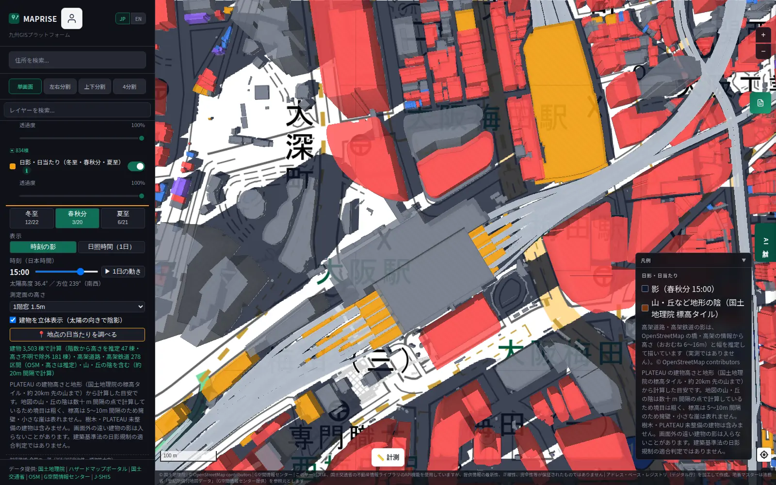
At the equinox, the sun rises to 36.4° and shadows shrink to less than half their winter length.
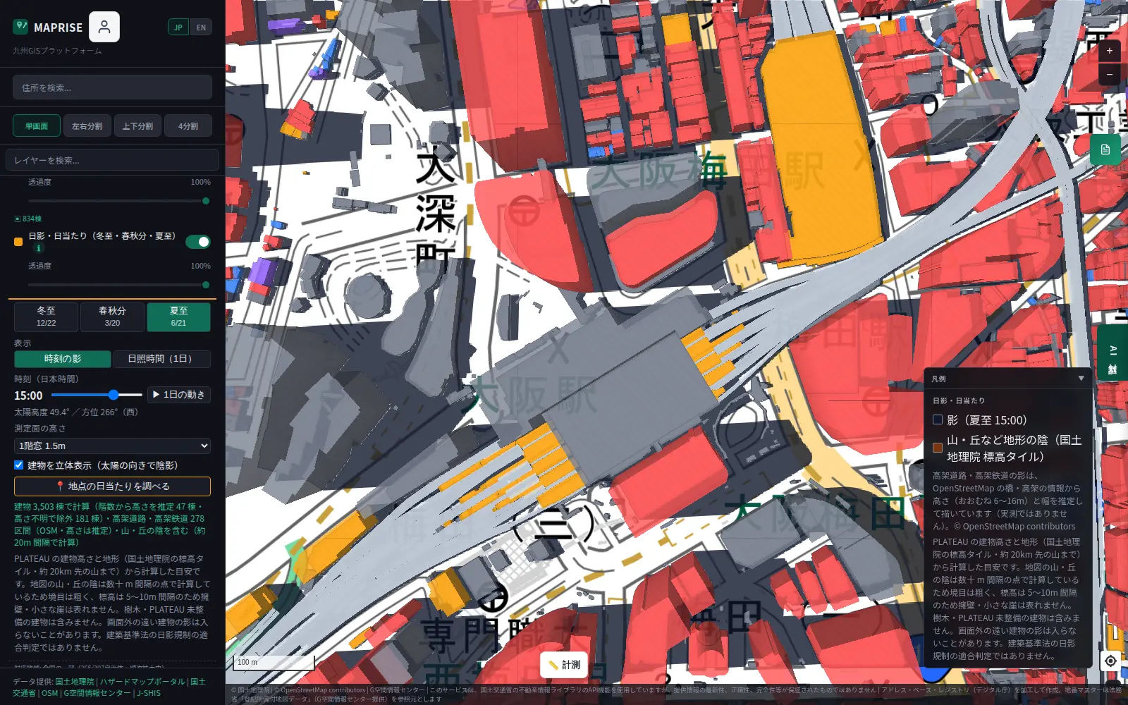
At the summer solstice the sun is at 49.4°, and shadows barely extend beyond the base of each building. The impression of the same place at the same hour is completely different between winter and summer.
How shadows move through the day
Next, let's compare the winter solstice in Nishi-Shinjuku, Tokyo, in the morning, at noon and in the afternoon.
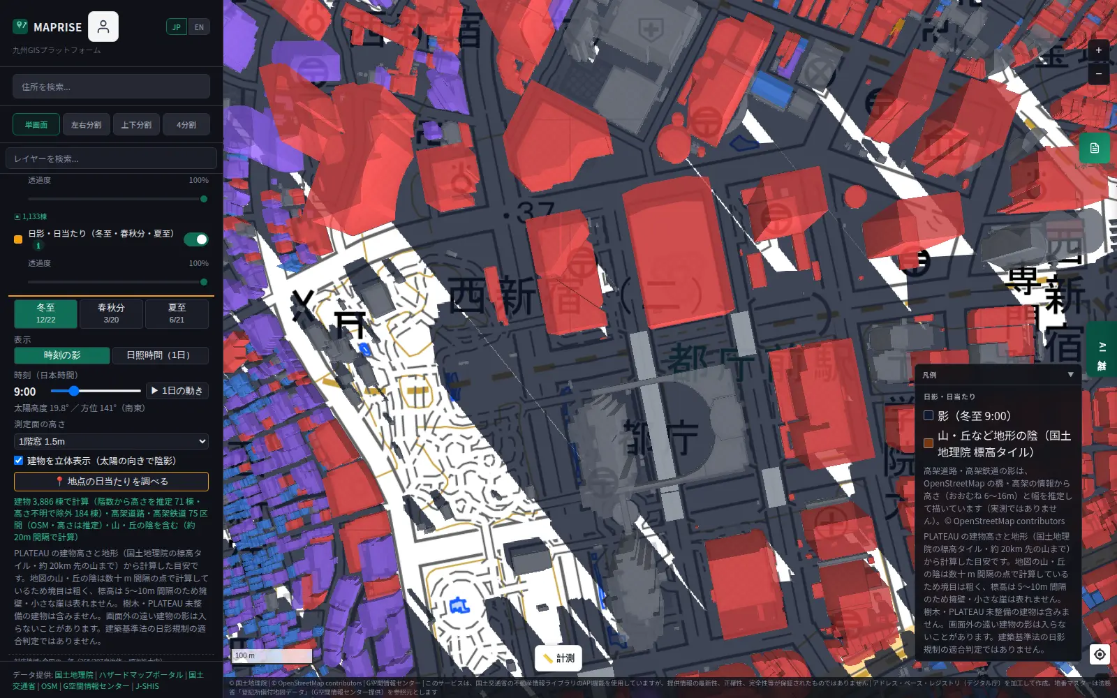
At 9:00, the sun is low in the southeast, and the high-rises cast long shadows to the northwest.
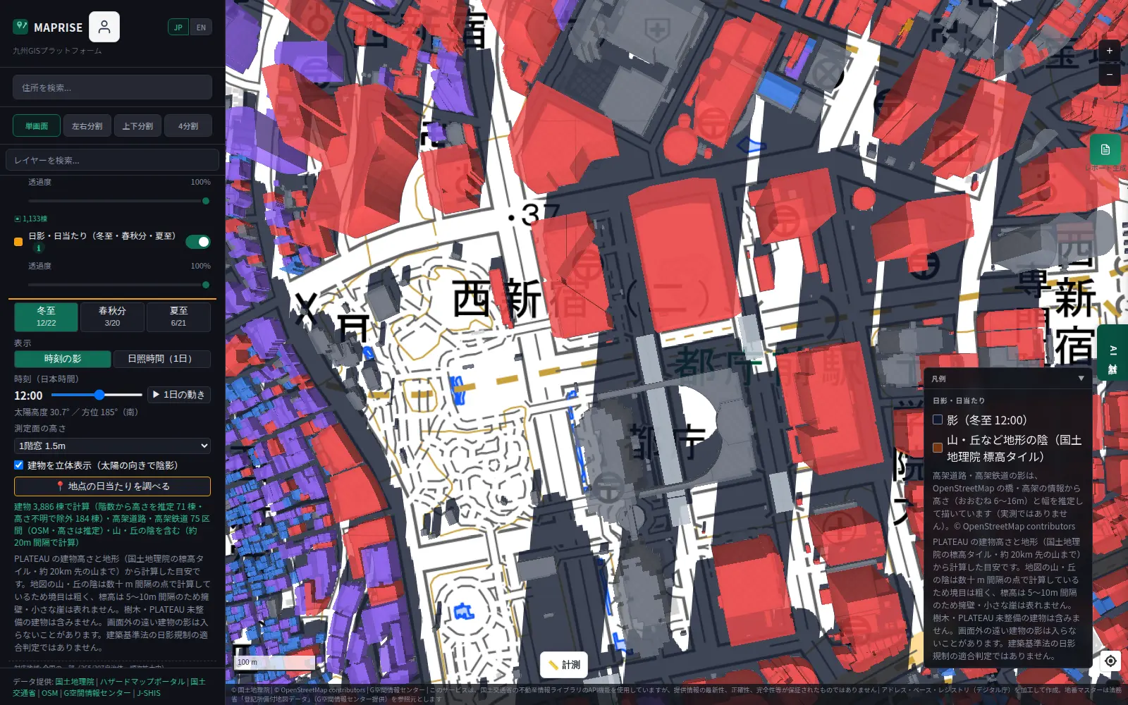
At noon, the sun is due south and shadows point due north. The sun's altitude on this day is 30.7°.
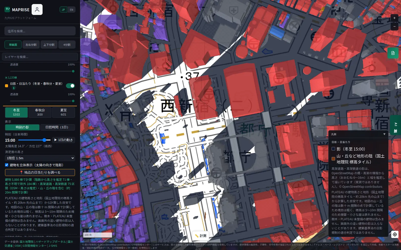
By 15:00 the sun has swung to the southwest, and the shadows lengthen again toward the northeast. In areas lined with high-rises, you can watch shadows sweep across the ground as time passes.
Sunlight hours as a heatmap
Switch to "Sunlight hours (day)" and, instead of just where shadows fall, you see how many hours of sun each spot receives in a day. Colors run from navy through blue and green to yellow as sunlight hours increase. You can choose the counting window: "apparent solar time 8:00–16:00" or "sunrise to sunset".
Here is the same area around Nagoya Station at the winter solstice and the summer solstice.
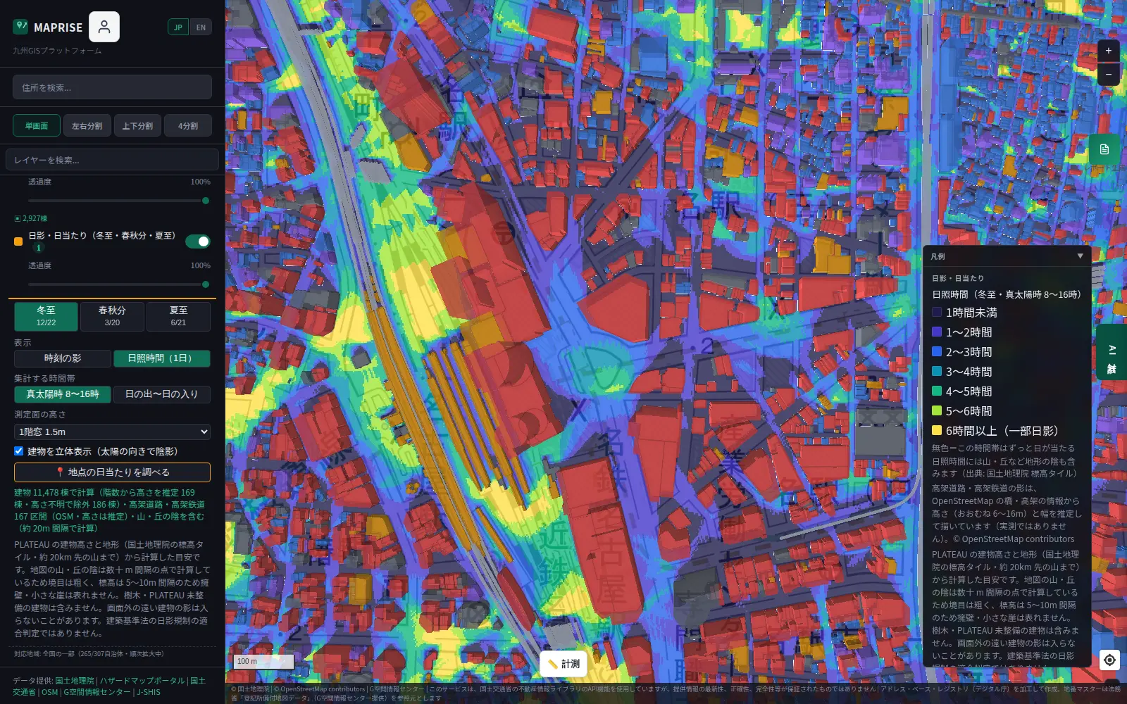
At the winter solstice, many streets behind high-rises and between buildings fall into the short-sunlight (navy to blue) range.
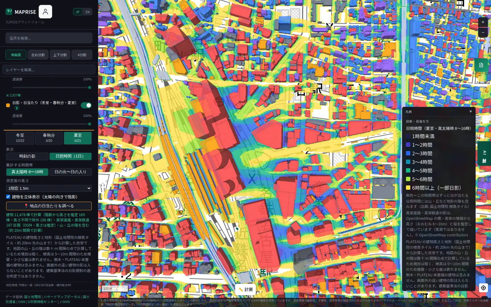
At the summer solstice, the yellow area grows substantially over the same range. You can compare the seasonal difference at a glance from how far the colors spread.
Here is Tenjin in Fukuoka at the winter solstice.
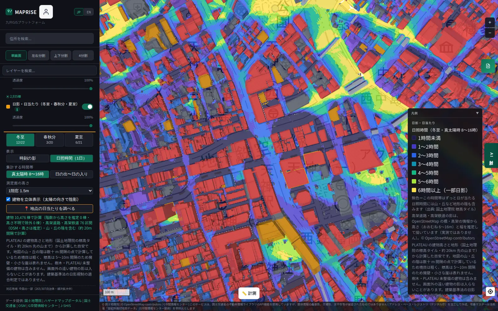
You can see by color that streets between buildings get little sun, while parks and wide intersections get much more.
Mountain shadows too
It's not only buildings: mountains and hills cast shadows as well. Using GSI elevation tiles, we calculate when the sun is blocked by terrain, covering mountains up to about 20 km from each point.
Here is central Tottori City at 9:00 on the winter solstice.
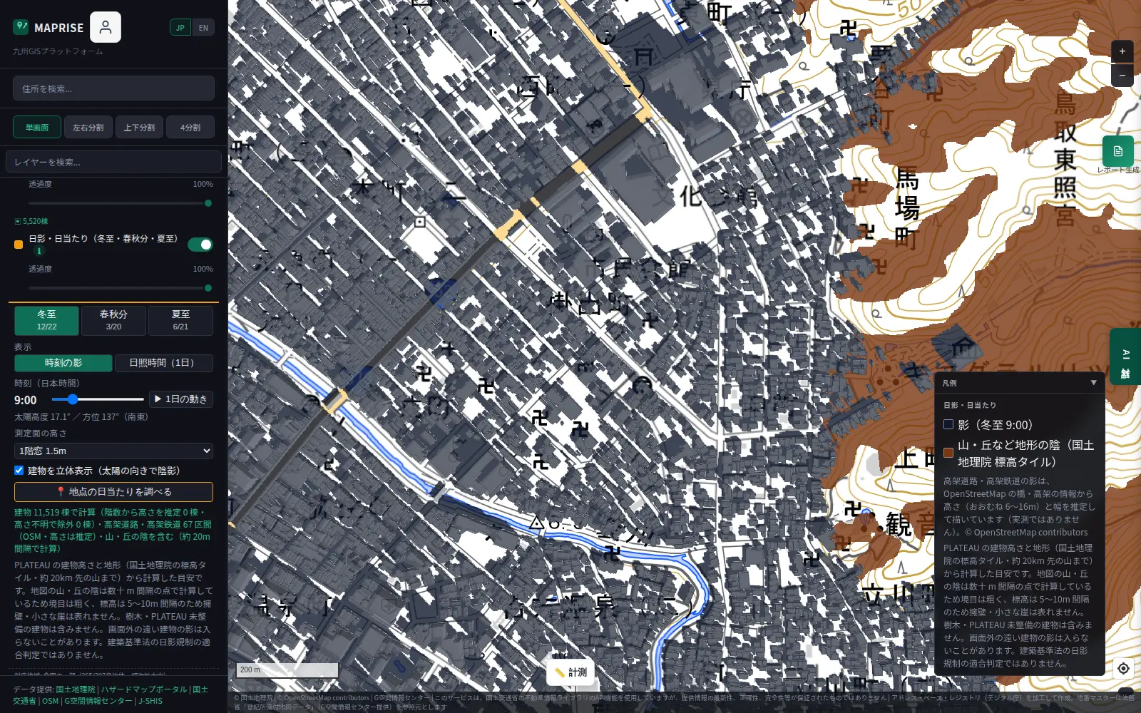
The brown area is shaded by mountains and hills. You can see that the mountain slope to the east blocks the low morning sun. Because terrain shade is drawn in a different color from building shadows (dark gray), you can tell "is this a building's shadow or the terrain's?"
The sunlight-hours heatmap also includes shade from mountains and hills.
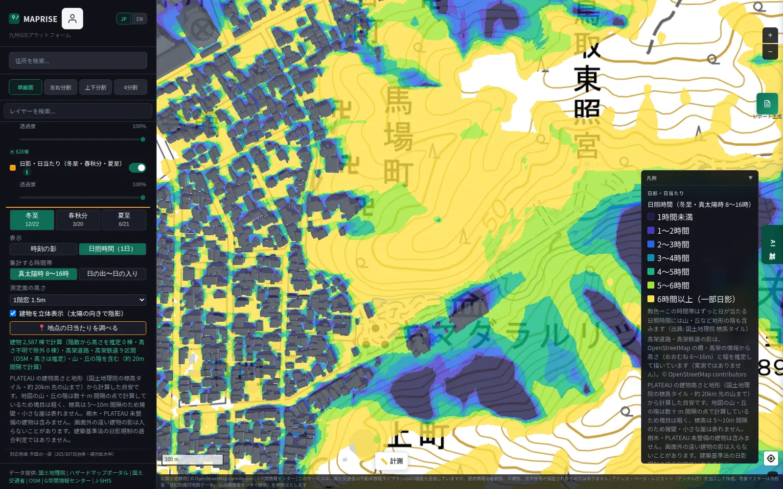
On land with relief, such as the foot of a mountain or a valley, looking only at buildings can overestimate sunlight hours. Including mountain shade should help reduce what you might miss.
Elevated roads and railways, too
Around stations and arterial roads, elevated roads and railways can cast long shadows on their surroundings. The feature estimates their height (roughly 6–16 m) and width from OpenStreetMap bridge and elevated-structure information and calculates the shadows accordingly.
In the Osaka Station images above, the elevated tracks leading into the station are drawn as gray bands, and you can see their shadows falling on the surroundings. Please note that elevated heights are estimates derived from tags, not measured values.
Click a point to compare the three seasons
Press "Check sunlight at a point" and click the map to see that point's sunlight hours side by side for the winter solstice, equinox and summer solstice.
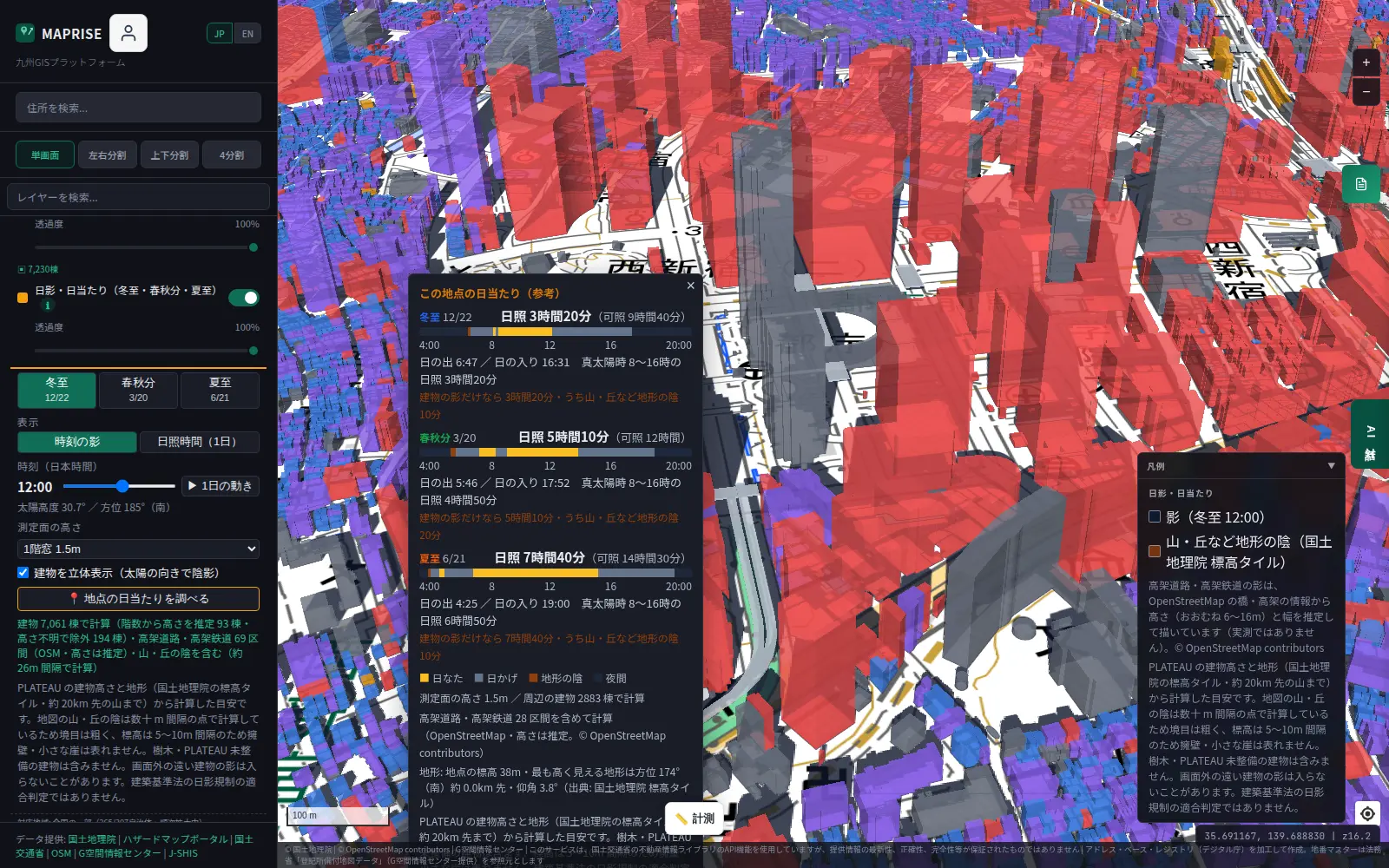
In this example, the same point gets 3 hours 20 minutes of sun at the winter solstice, 5 hours 10 minutes at the equinox and 7 hours 40 minutes at the summer solstice. The hourly bars show when it's sunny and when it's shaded. The popup also separates the result from building shadows alone from the result including mountain and hill shade, which we hope helps your review.
For early-stage land acquisition and development
We think this feature can help real-estate companies and developers in the early stages of evaluating a site, for example:
- Initial screening for land acquisition. Compare candidate sites' sunlight across several seasons, including the winter solstice, before visiting.
- Understanding the effect of neighboring buildings. See when, and how much, existing high-rises to the south or west cast shadows on a planned site.
- Evaluating valley and sloped land. Check sunlight hours including mountain shade in advance.
- Organizing selling points for sale or rental. See at a glance, by color, which parts of a site get long or short sunlight.
- Explaining to colleagues, lenders and stakeholders. Use the shadow views to explain, so the discussion of sunlight rests on a shared picture on the map.
We hope it serves as one input for narrowing down candidates, ahead of on-site checks and detailed studies by specialists.
Being upfront about data and calculations
This feature is only a rough guide to sunlight. Here are the assumptions and limits.
- Building heights: Buildings are treated as extruded prisms using PLATEAU heights (LOD1). Where height is unknown, we estimate it as number of floors × 3 m, and exclude buildings whose floors are also unknown.
- Not included: Trees and buildings not yet covered by PLATEAU are not considered. Shadows from distant buildings outside the screen may not be included.
- Mountain and hill shade: Calculated from GSI elevation tiles at points spaced tens of meters apart. Boundaries are coarse, and retaining walls and small cliffs do not appear. Foundation elevation differences for buildings on slopes are also not considered.
- Elevated roads and railways: Height and width are estimated from OpenStreetMap information.
- Sun position: Based on astronomical calculation, with an error of roughly 0.1°.
- Not a shadow-regulation check: The "apparent solar time 8:00–16:00" count matches the measurement window used in the Building Standards Act's shadow regulations, but it is not a compliance determination.
- Requirements: Because building heights are needed to compute shadows, the feature is available on the Starter plan or higher. Zoom in to level 13 or beyond for it to display.
For an actual project, be sure to have an architect or other specialist confirm shadow diagrams and shadow regulations.
Closing thoughts
Most people know that "land value also changes with sunlight". Yet until now there haven't been many ways to quickly check, parcel by parcel, winter-solstice shadows and the effect of surrounding buildings and mountains. We hope this feature makes the first round of checks a little easier for those evaluating sites.
Questions and feedback are welcome at info@maprise.jp.
Sources
- Maps and data: Ministry of Land, Infrastructure, Transport and Tourism, Project PLATEAU (3D city models); Geospatial Information Authority of Japan, elevation tiles (GSI Tiles) (processed and displayed in MAPRISE; providers and licenses are listed on our Data sources page, and the data you can view on the map on our Layer catalogue). © OpenStreetMap contributors
The sun and shadow display introduced here is reference information calculated from PLATEAU building heights, GSI elevation tiles and OpenStreetMap data. It does not include trees or buildings not yet covered by PLATEAU, and elevated-structure heights are estimates. It does not determine compliance with the shadow regulations of Japan's Building Standards Act. For individual projects, please consult an architect or other specialist.
Tags: #Shadow #Sunlight #Sunlight hours #PLATEAU #GSI #Land acquisition #Developers #Real estate
Other-language share text (exception cases)
Quick share above follows our platform-locked language policy (X-family in Japanese, LinkedIn in English). The four panes below let you grab the opposite-language body when needed — e.g. introducing an English post to a Japanese audience on X, or posting a Japanese article to LinkedIn in Japanese. Each pane offers both a copy button and a direct intent link.
📝 日影・日射を地図で再現 ― 建物・山・高架の影まで、冬至から夏至まで確認できます
PLATEAUの3D建物、国土地理院の標高データ、高架道路・鉄道の高さを組み合わせ、冬至・春秋分・夏至の影を時刻ごとに再現します。1日の日照時間のヒートマップも表示でき、用地取得の初期検討にお使いいただけます。
https://maprise.jp/ja/blog/plateau-sun-shadow/ #日影 #日射
🆕 新しいブログ記事を公開しました。

《日影・日射を地図で再現 ― 建物・山・高架の影まで、冬至から夏至まで確認できます》

PLATEAUの3D建物、国土地理院の標高データ、高架道路・鉄道の高さを組み合わせ、冬至・春秋分・夏至の影を時刻ごとに再現します。1日の日照時間のヒートマップも表示でき、用地取得の初期検討にお使いいただけます。

👉 詳しくはこちら: https://maprise.jp/ja/blog/plateau-sun-shadow/

#PLATEAU
📝 Sun and Shadow on the Map — Buildings, Mountains and Elevated Structures, from Winter to Summer Solstice
By combining PLATEAU 3D buildings, GSI elevation data and the heights of elevated roads and railways, MAPRISE reproduces shado…
https://maprise.jp/en/blog/plateau-sun-shadow/ #Shadow #Sunlight
🆕 New on the MAPRISE blog.

《Sun and Shadow on the Map — Buildings, Mountains and Elevated Structures, from Winter to Summer Solstice》

By combining PLATEAU 3D buildings, GSI elevation data and the heights of elevated roads and railways, MAPRISE reproduces shadows at the winter solstice, equinox and summer solstice, hour by hour. A daily sunlight-hours heatmap makes it a handy first check for land acquisition.

👉 Read the full post: https://maprise.jp/en/blog/plateau-sun-shadow/

#Shadow #Sunlight #Sunlighthours #PLATEAU #GSI