Using MAPRISE's 4-panel view, we line up AI-detected solar panels, aerial photos, elevation and steep-slope (cliff-collapse) warning zones. Prompted by the damage to solar facilities reported after the heavy rain of September 2026, we look at eight sites in Kyushu and Kita-Kanto where panels on slopes sit close to warning zones.
Hello, this is the MAPRISE development team. This time we show how to check, in MAPRISE, where solar panels line up on mountain slopes or on ground with large elevation differences, together with cliff-collapse warning zones.
The trigger was the heavy rain of September 2026. Following Typhoon No. 25, a solar power facility next to Lake Inba in Chiba Prefecture was flooded, with most of its panels reported to be under water. That was flood damage, but it made us wonder how panels on slopes fare in heavy rain. Damage to solar facilities on slopes is not new.
Slope-side solar facilities have been hit by heavy rain before
- West Japan heavy rain, July 2018. In Kobe, a 23 kW plant on a slope beside the Sanyo Shinkansen collapsed, and the bullet trains were briefly suspended. In Mihara, Hiroshima, a landslide about 100 m long hit a low-voltage solar plant.
- Aira, Kagoshima, July 2022. A sediment disaster at a solar plant construction site sent soil hundreds of meters onto private land, damaging fields and a warehouse. The national government considered tighter regulation.
Knowing this, it seems worthwhile to check on the map where panels on slopes are.
"Land that used to be forest" and heavy rain
We start from the following premise.
- Forest soil and roots are generally said to store rainwater and release it slowly.
- Where forest was cleared for panels, this capacity may be weaker than in the original forest.
- If so, in rain beyond expectations, water and soil may run off the slope more easily, raising the risk of landslides.
This is a general line of thinking. Actual risk depends heavily on geology, gradient, drainage design and construction, and this article does not speak to the safety of any individual facility.
Four conditions in a 4-panel view
MAPRISE's 4-panel view shows the same place at the same scale in four panels.
| Panel | Content | What it shows |
|---|---|---|
| Top left | Solar panel detection (AI-estimated coverage) | Where panels probably are (purple) |
| Top right | Aerial photo | The actual panels and the surrounding land |
| Bottom left | Elevation (colored elevation map) | Slope direction and height difference |
| Bottom right | Sediment-disaster warning zones (steep slope collapse) | Cliff-collapse zones (yellow = warning, red = special warning) |
The 4-panel view is available on the Starter plan or higher.
Five sites in Kyushu
We matched the AI-detected panel areas against the steep-slope warning zones using the map data, and chose places where panels sit close to a zone.
1. Iwato-cho, Makurazaki, Kagoshima ― a large plant on a slope facing the sea
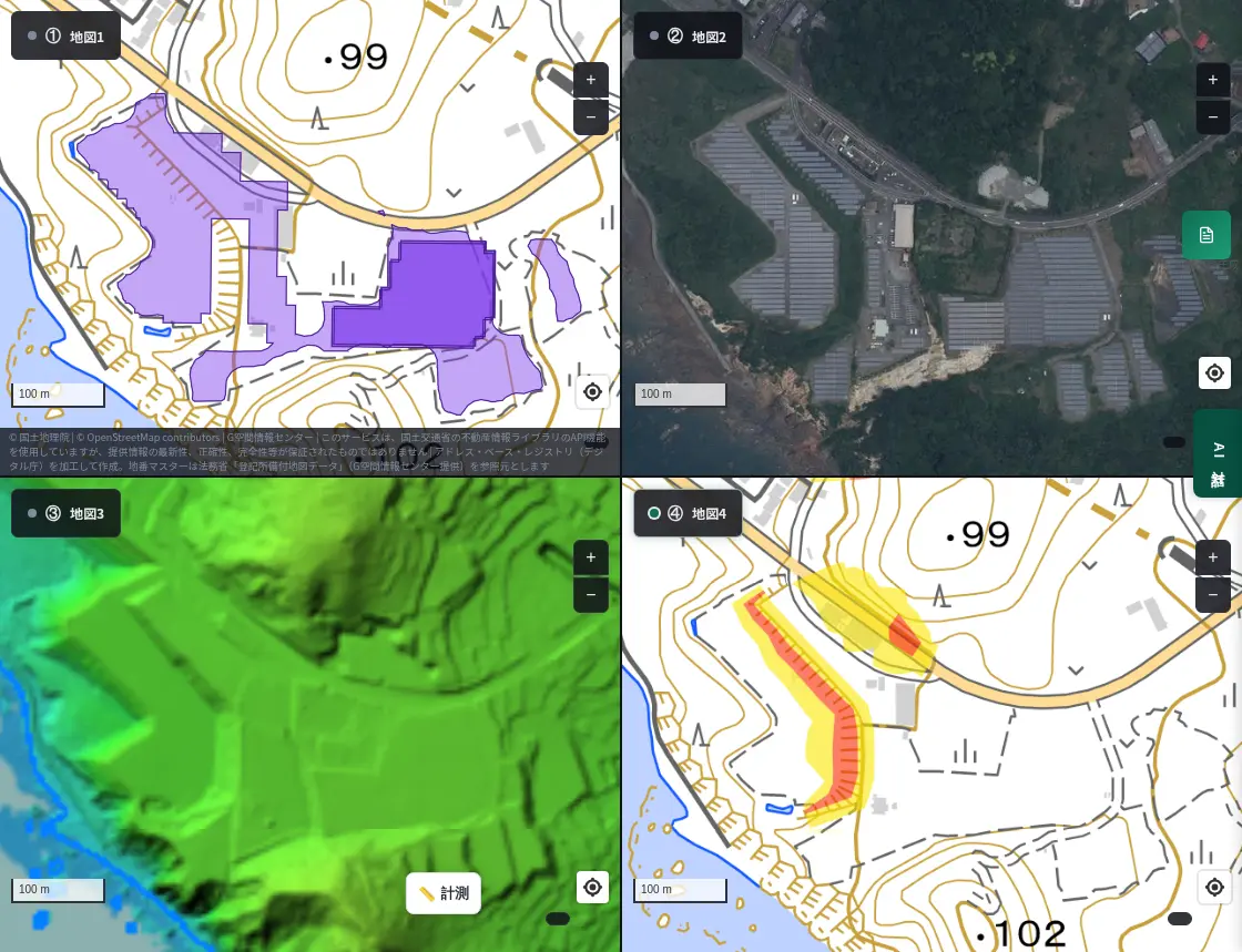
The aerial photo clearly shows rows of panels on a slope facing the sea. The purple area at top left is what the AI detected. At bottom right, red and yellow zones run in a band along the west edge of the panels. The colored elevation shows the ground dropping toward the sea.
2. Kariyado, Osaki, Kagoshima ― panels on a hilltop, wrapped by a warning zone
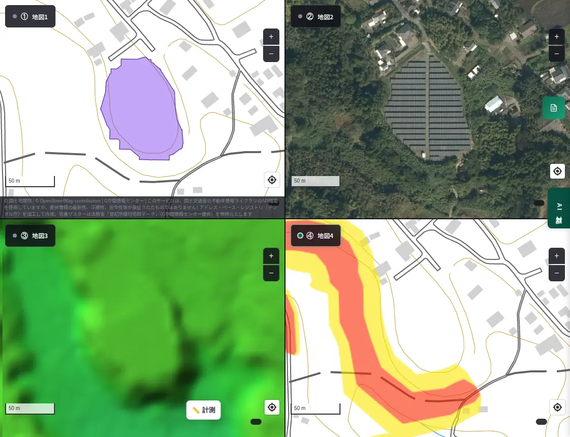
A warning zone (red and yellow) wraps around the west and south of the orderly rows of panels on the hilltop. The aerial photo also shows houses scattered around the panels.
3. Yamamuro, Kita-ku, Kumamoto ― a slope next to housing
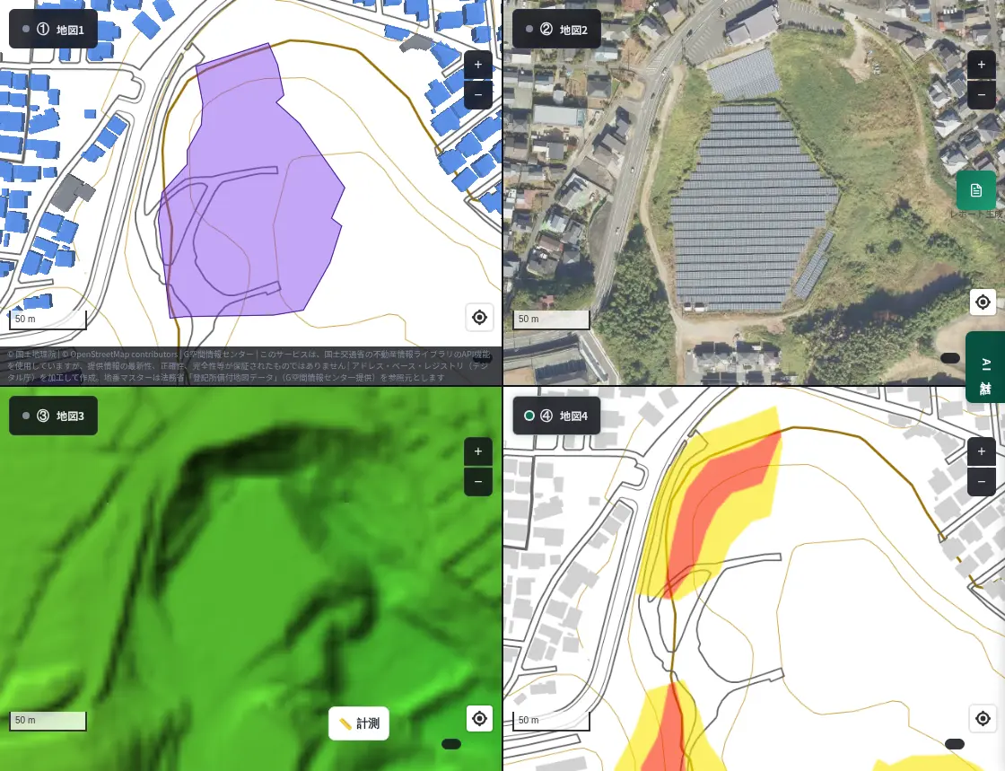
Panels sit on a hillside within a residential area. At top left you can see the distance to nearby buildings (blue). At bottom right a warning zone runs along the slope, and the aerial photo shows houses around it.
4. Kokubu-shigehisa, Kirishima, Kagoshima ― panels spread over a mountain slope
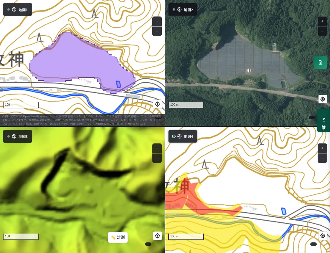
Panels spread widely over a forested slope. A road runs just south of the panels, and warning zones line the slope south of that road. The colored elevation shows how intricate the slopes are.
5. Kitagawachi-cho, Miyazaki ― cleared land in the hills
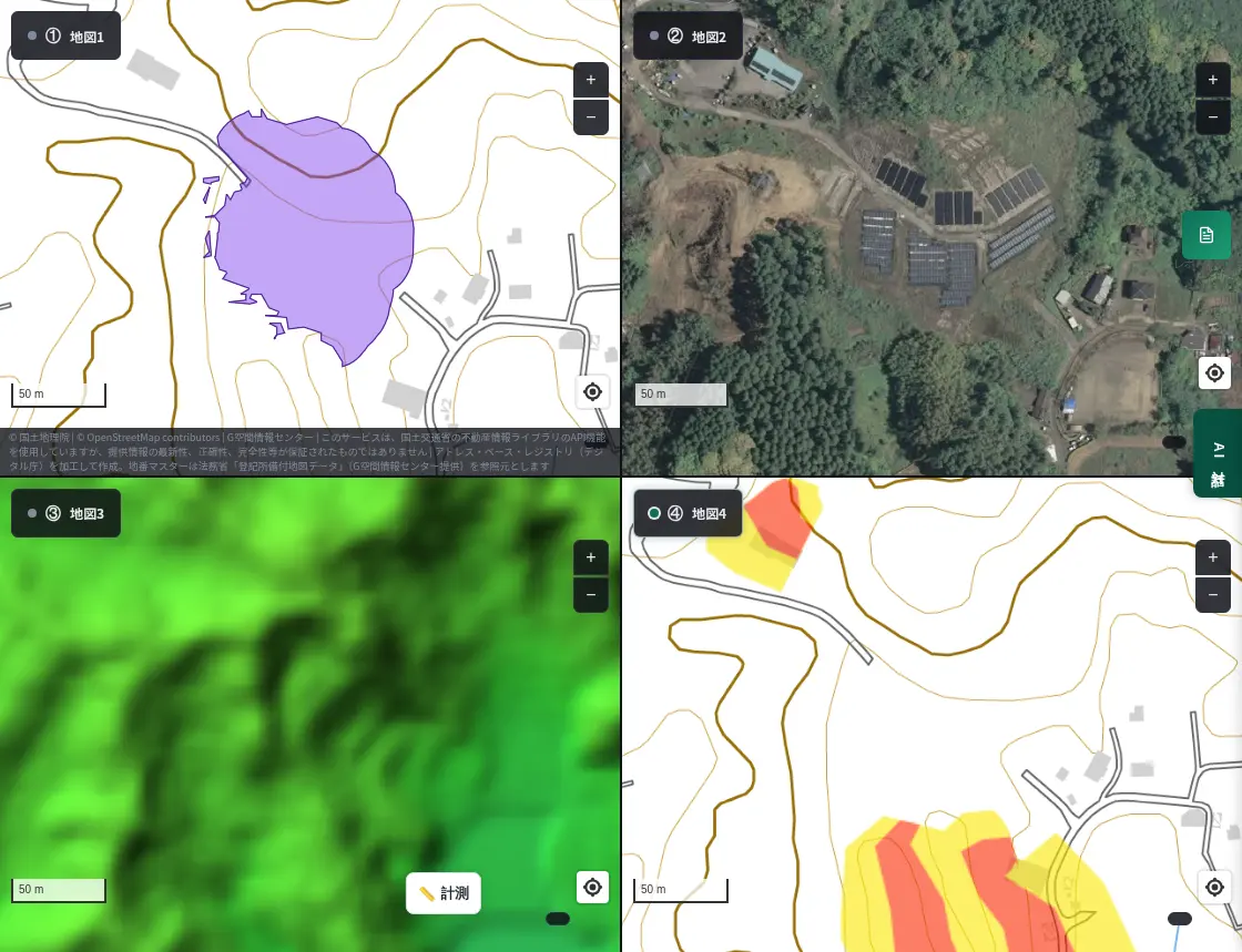
A few rows of panels stand on land cleared from the forest. The aerial photo shows bare soil, with forest all around. The warning zone lies on the slope a little way to the south.
Kita-Kanto too
Not only Kyushu. We ran the same matching in Gunma and northern Saitama and chose places where panels overlap or sit close to a warning zone.
6. Sakaguchi, Yoshii, Takasaki, Gunma ― a warning zone overlaps the west side of the panels
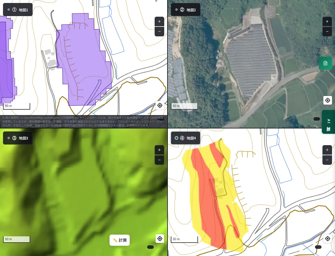
In the aerial photo, panels stand in rows along the slope. At bottom right, red and yellow warning zones overlap the west side of the panel area. Another group of panels is visible at the left edge.
7. Gobara, Annaka, Gunma ― a long strip of panels on a riverside slope
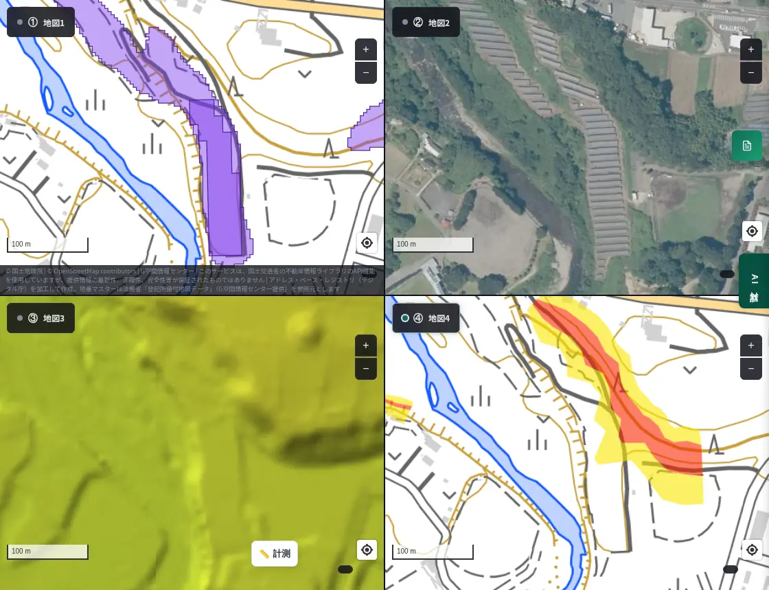
Panels line a slope along the river like a band. The warning zone at bottom right runs along this band of panels.
8. Kamikawa, Saitama ― a large plant beside housing
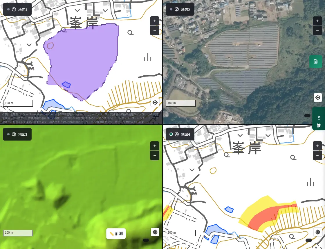
A large array spreads right next to a residential area. The warning zone lies on the slope southeast of the panels, and the aerial photo shows forest continuing behind them.
What to check before heavy rain
- Slope direction and steepness. Use the colored elevation map.
- Position relative to warning zones. See whether zones touch the panel edges, lie below the panels, or cover nearby homes and roads.
- What is downslope. Homes, roads, waterways and fields may be affected by water and soil.
- When heavy rain is forecast. Check evacuation information from your municipality and sediment-disaster alerts from the Japan Meteorological Agency.
About the data
- Panel areas are AI estimates from satellite imagery and may not match actual panel positions.
- Sediment-disaster warning zones come from GSI's hazard map tiles. A place without designation is not necessarily safe.
- This article introduces how to read the map; it does not judge the safety of any facility or land.
Questions or feedback are welcome at info@maprise.jp.
Sources
- Solar panels submerged: flooded solar facility (ABEMA TIMES)
- West Japan heavy rain exposed an unexpected weakness of solar (PVeye)
- Mega solar work resumes after a sediment disaster; the government moves to tighten rules (Nikkei xTECH)
- Maps and data: GSI Tiles (aerial photo, colored elevation) and hazard map (sediment-disaster warning zones) (processed and displayed in MAPRISE; providers and licenses are listed on our Data sources page, and the data you can view on the map on our Layer catalogue)
Tags: #solar power #landslide #steep slope #4-panel view #aerial photo #elevation #Kyushu
Other-language share text (exception cases)
Quick share above follows our platform-locked language policy (X-family in Japanese, LinkedIn in English). The four panes below let you grab the opposite-language body when needed — e.g. introducing an English post to a Japanese audience on X, or posting a Japanese article to LinkedIn in Japanese. Each pane offers both a copy button and a direct intent link.
📝 斜面に連なる太陽光パネルと、がけ崩れの警戒区域を4分割で見る ― 大雨のときに気をつけたい場所
太陽光パネルの検知、航空写真、標高、がけ崩れ(急傾斜地)の警戒区域を、MAPRISEの4分割表示で並べました。2026年9月の大雨で太陽光発電施設の被害が報じられたことをきっかけに、斜面に連なるパネルが警戒区域のそばにある場所を、九州と北関東の8か所で見てみました。
https://maprise.jp/ja/blog/solar-panels-on-slopes-heavy-rain/ #太陽光発電 #土砂災害
🆕 新しいブログ記事を公開しました。

《斜面に連なる太陽光パネルと、がけ崩れの警戒区域を4分割で見る ― 大雨のときに気をつけたい場所》

太陽光パネルの検知、航空写真、標高、がけ崩れ(急傾斜地)の警戒区域を、MAPRISEの4分割表示で並べました。2026年9月の大雨で太陽光発電施設の被害が報じられたことをきっかけに、斜面に連なるパネルが警戒区域のそばにある場所を、九州と北関東の8か所で見てみました。

👉 詳しくはこちら: https://maprise.jp/ja/blog/solar-panels-on-slopes-heavy-rain/
📝 Solar Panels on Slopes and Cliff-Collapse Warning Zones in a 4-Panel View ― Places to Watch in Heavy Rain
Using MAPRISE's 4-panel view, we line up AI-detected solar panels, aerial photos, elevation and steep-slope (cliff-colla…
https://maprise.jp/en/blog/solar-panels-on-slopes-heavy-rain/ #solarpower #landslide
🆕 New on the MAPRISE blog.

《Solar Panels on Slopes and Cliff-Collapse Warning Zones in a 4-Panel View ― Places to Watch in Heavy Rain》

Using MAPRISE's 4-panel view, we line up AI-detected solar panels, aerial photos, elevation and steep-slope (cliff-collapse) warning zones. Prompted by the damage to solar facilities reported after the heavy rain of September 2026, we look at eight sites in Kyushu and Kita-Kanto where panels on slopes sit close to warning zones.

👉 Read the full post: https://maprise.jp/en/blog/solar-panels-on-slopes-heavy-rain/

#solarpower #landslide #steepslope #4-panelview #aerialphoto
Related posts
- Japan's Calderas in Black-and-White Hillshade and Colored Elevation ― Aso, Mashu, Toya, Hakone and More2026-10-03
- Closed Lines Have Histories Too — Tracing Coal, Factory and Streetcar Lines on a Four-Panel Map2026-10-15
- You don't need to memorize 50+ layers — one-click Purpose Presets turn on exactly what you need2026-07-26