After the 2021 Atami debris-flow disaster, Japan enacted a new law regulating dangerous fill land. We've now mapped both the regulation zones that law created and a separate map of existing large-scale fill land (valley-fill and slope-attached). They look similar but are actually different things. Here's how they work, with real examples from Fukuoka City and the Kansai region, plus their relevance to real-estate disclosure.
Hello from the MAPRISE team. This time we're introducing two layers that are unglamorous but genuinely important from a disaster-risk standpoint: "fill-land regulation zones" and "large-scale fill land."
Why fill land, and why now
This starts with the large-scale debris flow disaster in the Izusan district of Atami City, Shizuoka Prefecture, in July 2021. Fill land that had collapsed upstream turned into a debris flow that swept through the town below, killing many people. As the disaster was investigated, it turned out that the fill land in question sat on land that wasn't classified as residential land, farmland, or forest (it was being used as a materials storage yard), which meant it had fallen completely outside the scope of the laws in force at the time.
In response, Japan's existing "Residential Land Development Regulation Act" was fundamentally revised, and the "Act on Regulation of Residential Land Development and Specified Embankment" (commonly known as the "fill-land regulation law") came into effect in May 2023. The key change: dangerous fill land is now regulated under one uniform, nationwide standard, regardless of whether the land is classified as residential, agricultural, or forest. Prefectures and designated cities designate regulation zones, and any fill or cut work above a certain scale within those zones now requires a permit.
In other words, fill-land regulation zones are a genuinely new system. The fact that how far along zone designation is varies by municipality partly reflects how recently the law came into force.
These two layers look alike, but they're actually different things
We've implemented two layers this time — "fill-land regulation zones" and "large-scale fill land" — and while they sound similar, they're not the same thing.
1. Fill-land regulation zones (residential land development work regulation areas / specified fill-land regulation areas)
These are the zones designated under the fill-land regulation law described above. Within these zones, any fill or cut work above a certain scale requires a permit from the prefectural governor or equivalent authority. There are two types: "residential land development work regulation areas," and "specified fill-land regulation areas," which also cover non-residential land such as farmland and forest. The key point: this regulates fill work that happens from now on.
2. Large-scale fill land (valley-fill and slope-attached types)
This, on the other hand, is a map of where large-scale fill work has already happened in the past. There are two types: "valley-fill," where a valley or stream was filled in to create residential land, and "slope-attached," where fill was piled onto a sloped hillside. This information predates the fill-land regulation law — it grew out of a separate, longer-running effort: after large-scale fill land suffered "landslide-like collapse" (滑動崩落) during earthquakes such as the 2004 Niigata Chuetsu earthquake and the 2011 Great East Japan Earthquake, causing real damage to residential land, the national government began encouraging municipalities to carry out "deformation prediction surveys." This isn't a regulation zone itself — it's reference information indicating "this land may sit on top of large-scale fill."
The Atami disaster happened to involve fill land, which is part of why the damage was so severe, but what these two layers are really getting at is a more fundamental question: is this land its original, natural ground, or was it artificially created by filling in a valley or piling fill onto a slope? How the ground was formed has a direct bearing on how it behaves during an earthquake or heavy rain.
Try it: Fukuoka City
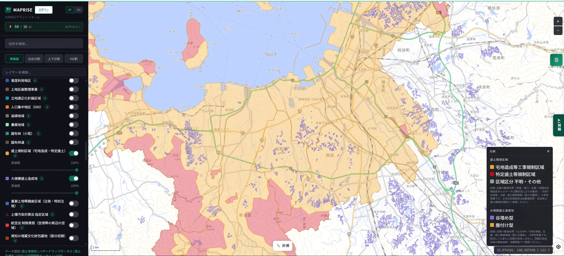
Here's what it actually looks like when you turn this on for Fukuoka City in MAPRISE.
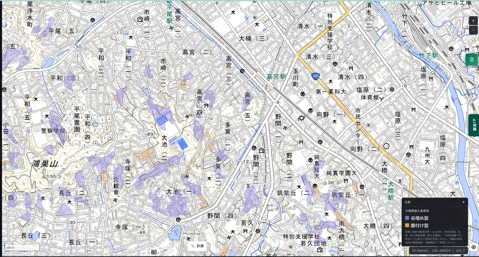
Zooming into the hilly residential area of Minami Ward in Fukuoka City, you can clearly see valley-fill (purple) large-scale fill land clustered along the valley contours.
Try it: the Kansai region
To show this isn't a Kyushu-only feature, let's look at Kansai too.
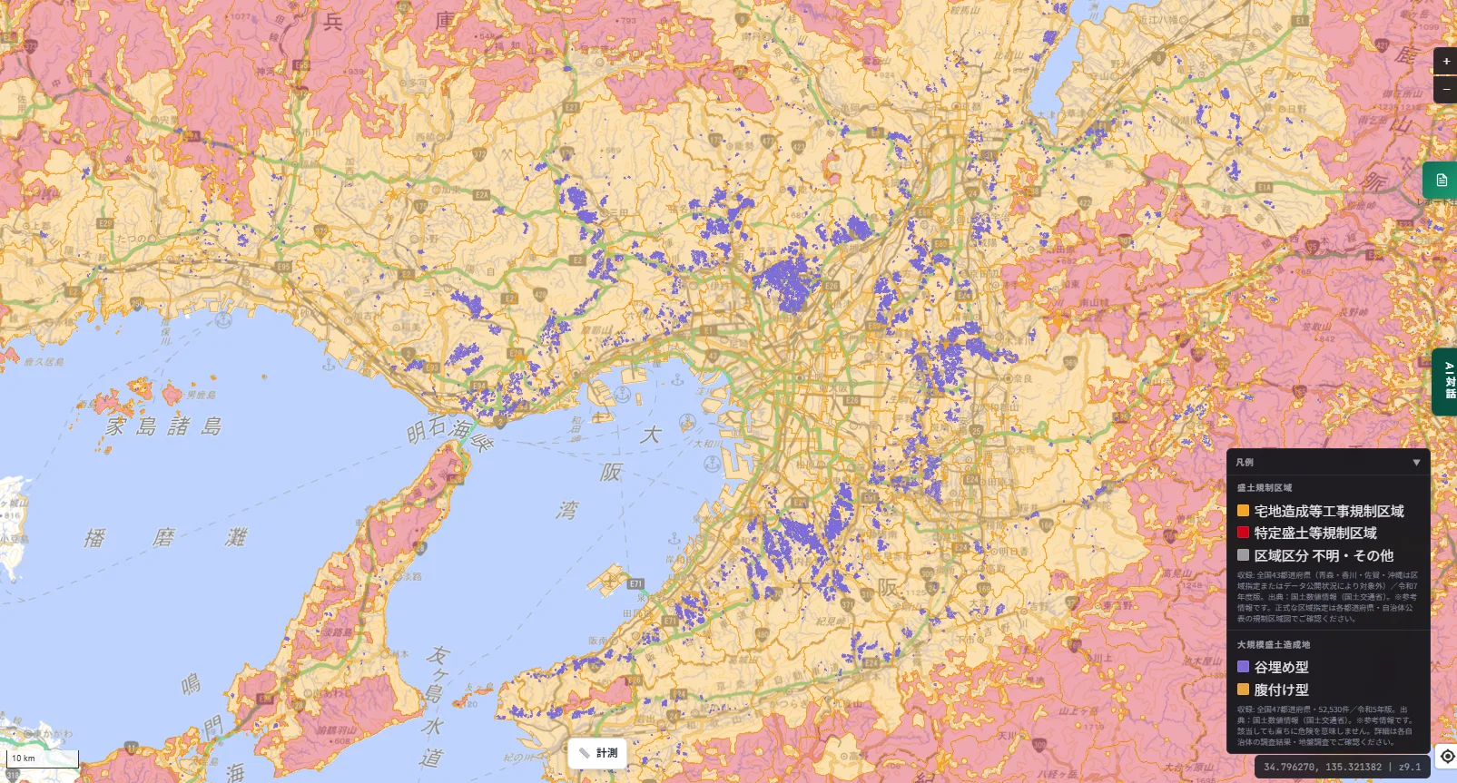
At a glance, you can see how densely regulation zones and large-scale fill land cover the hills surrounding Osaka and Kobe. It's a striking reminder that many of the suburban new towns spreading out from these cities were built by developing exactly this kind of hilly terrain.
How to read the legend
This layer combines both systems into a single legend panel.
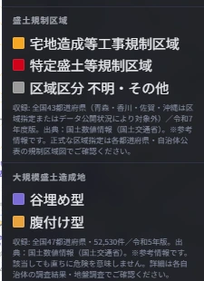
Fill-land regulation zones break down into three categories: residential land development work regulation area (orange), specified fill-land regulation area (red), and zone type unclear / other (gray). Large-scale fill land breaks down into two: valley-fill (purple) and slope-attached (orange). The colors can look similar at a glance, so use the section heading in the legend ("Fill-Land Regulation Zones" vs. "Large-Scale Fill Land") to tell them apart.
What real-estate professionals check, and how it relates to disclosure
Fill-land regulation zones (residential land development work regulation areas / specified fill-land regulation areas) are one of the legal restrictions that must be explained as part of the disclosure statement under Article 35, Paragraph 1, Item 2 of Japan's Building Lots and Buildings Transaction Business Act (Article 3, Paragraph 1, Item 27 of its enforcement order). Whether a target property falls within one of these zones is, in practice, one of the first things worth checking.
Large-scale fill land information, on the other hand, is different from the regulation zones themselves and isn't a legally mandated disclosure item tied to a specific zone designation (if the land has been designated as a "residential land disaster prevention area," that requires separate confirmation). Even so, whether a property sits on valley-fill or slope-attached large-scale fill land is a genuinely useful thing to check in practice when assessing earthquake or heavy-rain risk. Where it applies, a reasonable next step is to check the municipality's published deformation prediction survey results, or arrange a ground survey if warranted.
In both cases, what's shown on the map is reference information. For official zone designations and fill-construction history, please check the regulation zone maps and survey results published by the relevant prefecture or municipality.
Being upfront about coverage
Fill-land regulation zones cover 43 of Japan's 47 prefectures (FY2025 edition). Aomori, Kagawa, Saga, and Okinawa are excluded, depending on the state of zone designation or data publication. Since this is a new system, how far zone designation and data preparation have progressed genuinely varies by municipality.
Large-scale fill land covers all 47 prefectures nationwide, 52,530 records (FY2023 edition). This one is complete across all prefectures, but a match doesn't mean immediate danger — for details, please check the relevant municipality's survey results and ground surveys.
We want to be upfront: for neither layer is the same level of precision or granularity of information publicly available everywhere.
Closing — a starting point for learning your land's history
It's entirely possible to live somewhere for years without ever realizing the ground beneath you was once a valley that got filled in, or a slope reshaped with piled fill. We hope this layer gives you a small starting point for looking into the history of the land you live on, or a property you're considering.
On that note of digging into land history: being able to overlay this with contour lines and land use from historical topographic maps dating back to the Meiji era would make it much easier to directly confirm where valleys and streams used to run. We haven't built that yet, but it's something we'd like to consider as a future development item.
Questions or feedback are always welcome at info@maprise.jp.
The fill-land regulation zone and large-scale fill land data introduced in this post is reference information created from National Land Numerical Information (MLIT). Fill-land regulation zones cover 43 of Japan's 47 prefectures (Aomori, Kagawa, Saga, and Okinawa excluded depending on zone designation or data-publication status; FY2025 edition); large-scale fill land covers all 47 prefectures nationwide, 52,530 records (FY2023 edition). A match does not necessarily indicate immediate danger — for official zone designations and fill-construction history, please check the regulation zone maps and survey results published by the relevant prefecture or municipality. For how this relates to disclosure obligations under the Building Lots and Buildings Transaction Business Act in a specific transaction, please consult a licensed real-estate transaction specialist or other qualified professional.
Tags: #Fill-land regulation #Large-scale fill land #Disaster risk #Real estate disclosure #Nationwide
Other-language share text (exception cases)
Quick share above follows our platform-locked language policy (X-family in Japanese, LinkedIn in English). The four panes below let you grab the opposite-language body when needed — e.g. introducing an English post to a Japanese audience on X, or posting a Japanese article to LinkedIn in Japanese. Each pane offers both a copy button and a direct intent link.
📝 その土地、実は盛土かもしれません ― 盛土規制区域と大規模盛土造成地を地図にしました
2021年の熱海市土石流災害を受けて生まれた新しい法律「盛土規制法」に基づく規制区域と、谷を埋めて造成された宅地の分布を示す「大規模盛土造成地」。似ているようで実は別物のこの2つのレイヤーを実装しました。福岡市・関西圏の実例、凡例の見方、そして重要事項説明との関係まで紹介します。
https://maprise.jp/ja/blog/fill-land-regulation-and-large-scale-fill/ #盛土規制法 #大規模盛土造成地
🆕 新しいブログ記事を公開しました。

《その土地、実は盛土かもしれません ― 盛土規制区域と大規模盛土造成地を地図にしました》

2021年の熱海市土石流災害を受けて生まれた新しい法律「盛土規制法」に基づく規制区域と、谷を埋めて造成された宅地の分布を示す「大規模盛土造成地」。似ているようで実は別物のこの2つのレイヤーを実装しました。福岡市・関西圏の実例、凡例の見方、そして重要事項説明との関係まで紹介します。

👉 詳しくはこちら: https://maprise.jp/ja/blog/fill-land-regulation-and-large-scale-fill/
📝 That Land Might Actually Be Fill — We Mapped Fill-Land Regulation Zones and Large-Scale Fill Land
After the 2021 Atami debris-flow disaster, Japan enacted a new law regulating dangerous fill land. We've now …
https://maprise.jp/en/blog/fill-land-regulation-and-large-scale-fill/ #Fill-landregulation #Large-scalefillland
🆕 New on the MAPRISE blog.

《That Land Might Actually Be Fill — We Mapped Fill-Land Regulation Zones and Large-Scale Fill Land》

After the 2021 Atami debris-flow disaster, Japan enacted a new law regulating dangerous fill land. We've now mapped both the regulation zones that law created and a separate map of existing large-scale fill land (valley-fill and slope-attached). They look similar but are actually different things. Here's how they work, with real examples from Fukuoka City and the Kansai region, plus their relevance to real-estate disclosure.

👉 Read the full post: https://maprise.jp/en/blog/fill-land-regulation-and-large-scale-fill/

#Fill-landregulation #Large-scalefillland #Disasterrisk #Realestatedisclosure #Nationwide