Near any airport, there's a legal 'invisible ceiling' hanging over the city below it. We've now implemented a map layer for Japan's Civil Aeronautics Act height-restriction surfaces (six types, including approach and horizontal surfaces). Along the way: why buildings near Hakata Station tend to be short, nationwide coverage of airports and heliports, and a casual walkthrough of the legend.
Hello from the MAPRISE team. This one's a little nerdy, but it matters more than you'd think: there's a legally defined "invisible ceiling" hanging over the land near any airport. We've now made it possible to see that ceiling directly on the map.
There's an invisible ceiling near every airport
For aircraft to take off and land safely, the airspace around an airport is carved up into height-restriction zones defined by Japan's Civil Aeronautics Act. These are called "restriction surfaces." Some rise gently along the extension of the runway; others form a flat disc at a fixed height over the whole airport. Six differently shaped surfaces combine to build a three-dimensional "ceiling" specific to each airport.
You'd probably never notice this in daily life, but it's a real legal constraint. In plenty of areas nationwide, how tall you're allowed to build isn't just a matter of zoning, building coverage ratio, or floor area ratio — it's also bounded by this ceiling.
Why the area around Hakata Station is full of short buildings
If you live in Fukuoka, you may have vaguely noticed this: for such a central area, Hakata Station and Tenjin don't have many tall buildings.
That's not your imagination. Fukuoka Airport sits right next to the city center, so most of downtown Fukuoka — Hakata Station, Tenjin, Nakasu — falls under one of these restriction surfaces. Here's what it actually looks like when you turn this on in MAPRISE around Hakata Station.
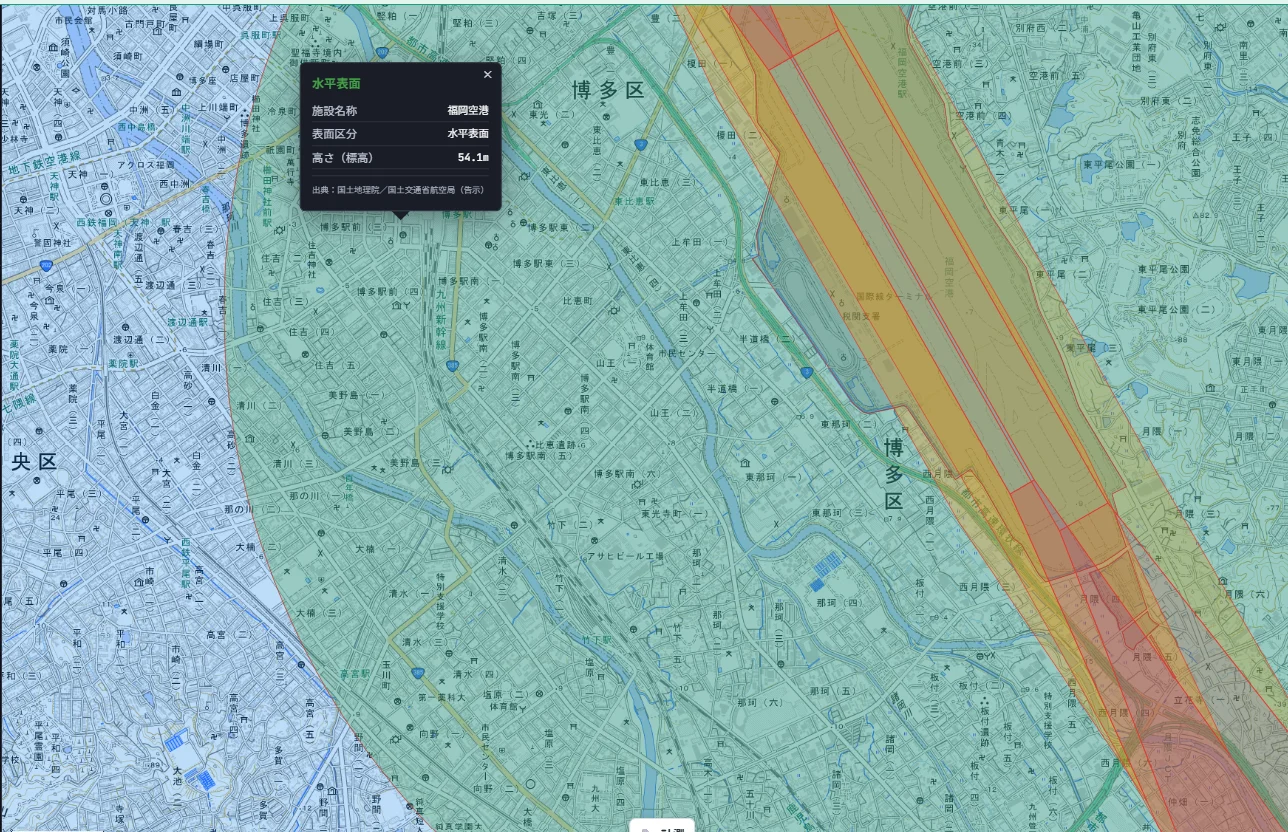
The horizontal surface around Hakata Station comes out to 54.1 meters. That number happens to line up almost exactly with the commonly cited figure that "height limits around Hakata Station are roughly 54 meters."
This restriction hasn't always been fixed in place, by the way. In 2014, Japan's National Strategic Special Zone framework was used to relax the height limit for the Tenjin district on an area-by-area basis, opening the door to buildings over 100 meters tall — the redevelopment push known as "Tenjin Big Bang." Similar relaxations have since spread to parts of the Hakata area too. Then in 2021, the entire mechanism for relaxing height limits area-by-area was extended nationwide, no longer limited to special zones. In other words, this "invisible ceiling" can actually move over time.
Using it is simple
Search "航空法 制限表面" (aviation-law restriction surfaces) in the layer menu and switch it on. From there, just look at the map — you can immediately see which surface category applies to a location and roughly how high it can go.
Let's talk legend trivia for a second
A "restriction surface" isn't actually just one thing. This layer color-codes six distinct surface types (plus a "site" category):
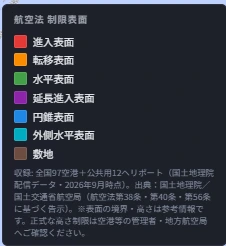
Roughly speaking: the approach surface is the corridor planes descend through from the runway end; the transitional surface is the slope beside it; the horizontal surface is a flat disc spanning the whole area above the airport at a fixed height; the extended approach surface stretches the approach surface even further out; the conical surface rises in a cone shape just outside the horizontal surface; and the outer horizontal surface sits beyond that. Look at these six colors together and it's immediately obvious that the height limit can be wildly different from one spot to the next, even within the same airport.
This actually covers official airports and heliports nationwide
You might assume this is a Fukuoka-only thing, but it isn't. This layer covers 97 airports plus 12 public heliports nationwide — 109 facilities in total. Just within Kyushu alone, that's already a lot of coverage.
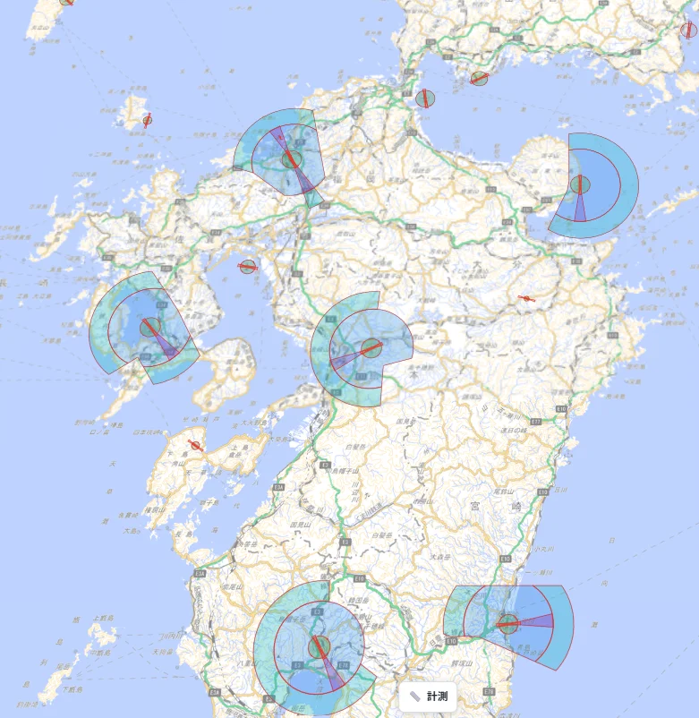
The source is data distributed by the Geospatial Information Authority of Japan, which traces back to official notices published in Japan's official gazette by the Japan Civil Aviation Bureau, under Articles 38, 40, and 56 of the Civil Aeronautics Act. Since this is official notice data, there was never really a reason to limit it to one region. So this feature launched nationwide from day one — it isn't a Kyushu-first rollout.
Kanto is covered too, of course
To prove this isn't just a Kyushu story, let's look at Kanto. Both Haneda and Narita airports show their own restriction surfaces just as clearly.
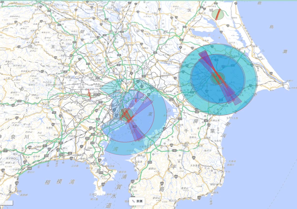
Looking at Haneda Airport (officially "Tokyo International Airport") individually, even just its conical surface has a clearly defined minimum and maximum height. Bigger airports tend to have restrictions covering a wider area.
A quick word on how this relates to real-estate disclosure
Article 35, Paragraph 1, Item 2 of Japan's Building Lots and Buildings Transaction Business Act (specifically Item 53 of Article 3, Paragraph 1 of its enforcement order) lists height restrictions under the Civil Aeronautics Act among the matters that must be explained as part of the disclosure statement. This layer can be used as reference information for that item.
That said, the surface boundaries and heights shown here are reference information based on official notices. Confirming the official restriction on a specific parcel still requires checking with the relevant airport manager or regional Civil Aviation Bureau — a note we've also included directly on the map.
Closing
There's something quietly satisfying about learning the legal reason behind a cityscape detail you'd only ever noticed vaguely — "huh, why are the buildings around here so short?" It's directly useful for disclosure-statement work, but honestly, it's also just a fun bit of trivia on its own. Give it a try and take a look at the airport near where you live.
Questions or feedback are always welcome at info@maprise.jp.
The aviation-law restriction surface data introduced in this post is reference information created from data distributed by the Geospatial Information Authority of Japan (based on official notices published by the Japan Civil Aviation Bureau under Articles 38, 40, and 56 of the Civil Aeronautics Act). Surface boundaries and heights are reference information only; please contact the relevant airport manager or regional Civil Aviation Bureau to confirm official height restrictions. This layer can serve as reference information related to Article 35, Paragraph 1, Item 2 of the Building Lots and Buildings Transaction Business Act (Article 3, Paragraph 1, Item 53 of its enforcement order), but displaying this layer alone does not fully satisfy the disclosure obligation under that item.
Tags: #Aviation law #Height restrictions #Real estate disclosure #Nationwide #Fukuoka
Other-language share text (exception cases)
Quick share above follows our platform-locked language policy (X-family in Japanese, LinkedIn in English). The four panes below let you grab the opposite-language body when needed — e.g. introducing an English post to a Japanese audience on X, or posting a Japanese article to LinkedIn in Japanese. Each pane offers both a copy button and a direct intent link.
📝 空港の周りだけ『見えない天井』がある ― 航空法の高さ制限を地図に描きました
空港の近くでは、法律上の『見えない天井』が街の上に広がっています。今回、航空法に基づく高さ制限(進入表面・水平表面など6種類)を地図レイヤーとして実装しました。博多駅前がなぜ低いビルばかりなのか、というローカルなネタも交えつつ、全国の空港・ヘリポート対応、凡例の見方までフランクに紹介します。
https://maprise.jp/ja/blog/aviation-restriction-surfaces/ #航空法 #高さ制限
🆕 新しいブログ記事を公開しました。

《空港の周りだけ『見えない天井』がある ― 航空法の高さ制限を地図に描きました》

空港の近くでは、法律上の『見えない天井』が街の上に広がっています。今回、航空法に基づく高さ制限(進入表面・水平表面など6種類)を地図レイヤーとして実装しました。博多駅前がなぜ低いビルばかりなのか、というローカルなネタも交えつつ、全国の空港・ヘリポート対応、凡例の見方までフランクに紹介します。

👉 詳しくはこちら: https://maprise.jp/ja/blog/aviation-restriction-surfaces/
📝 There's an Invisible Ceiling Near Every Airport — We Mapped It
Near any airport, there's a legal 'invisible ceiling' hanging over the city below it. We've now implemented a map layer for Japan's Civil Aeronautics Act…
https://maprise.jp/en/blog/aviation-restriction-surfaces/ #Aviationlaw #Heightrestrictions
🆕 New on the MAPRISE blog.

《There's an Invisible Ceiling Near Every Airport — We Mapped It》

Near any airport, there's a legal 'invisible ceiling' hanging over the city below it. We've now implemented a map layer for Japan's Civil Aeronautics Act height-restriction surfaces (six types, including approach and horizontal surfaces). Along the way: why buildings near Hakata Station tend to be short, nationwide coverage of airports and heliports, and a casual walkthrough of the legend.

👉 Read the full post: https://maprise.jp/en/blog/aviation-restriction-surfaces/

#Aviationlaw #Heightrestrictions #Realestatedisclosure #Nationwide #Fukuoka