Takeda Shingen, the 'Tiger of Kai', left his mark on flood control and water use as well as on the battlefield. Using hillshade, colored elevation, Meiji-era wetlands, land use, flood-depth assumptions and aerial photos from the same data MAPRISE uses, we looked at the Shingen Levee in Kai City, Yamanashi.
Hello, this is the MAPRISE development team. Last time we checked the water attack on Bitchu Takamatsu Castle against the map. This time we stay in the Sengoku period and look at water and land again. The leading figure is Takeda Shingen, the "Tiger of Kai", and the Shingen Levee in Ryuo, Kai City, Yamanashi.
A strong warrior band needs national strength to support it. Shingen is said to have left large achievements not only on the battlefield but also in flood control and water use, working with the rivers of his province. The Shingen Levee is the best known of them. We lined up hillshade, colored elevation, Meiji-era wetlands, land use, flood-depth assumptions and aerial photos, all from the same Geospatial Information Authority of Japan (GSI) and related data MAPRISE uses, to read this work of more than 400 years ago.
Sengoku Kai and its unruly rivers
Kai Province centered on the Kofu Basin, surrounded by mountains. Swift rivers flowed into the basin, and two of them, the Kamanashi River and the Mikuri River running down an alluvial fan from the Southern Alps, were unruly rivers that changed course with every flood. The Ministry of Land, Infrastructure, Transport and Tourism (MLIT) also describes the Kamanashi as one of the difficult places where swift rivers meet.
Shingen took over the family in 1541, later pushed into Shinano, and fought Uesugi Kenshin at Kawanakajima (1553 to 1564). To keep fighting, he needed fields to produce food and people to live and work there. Protecting the basin's fields and villages from floods, and making water a resource, was a matter that directly affected national strength.
What is the Shingen Levee?
The Shingen Levee, in Ryuo (Kai City), is said to have been built by Shingen to tame the Kamanashi River's floods. Records originally call it "Ryuo no kawayoke". Kai City's explanation says it was completed in 1560 (Eiroku 3) after 17 years, with a new vision for flood control.
The start year and the construction period cannot be confirmed from records, however. One explanation links it to the great flood of 1542 (Tenbun 11), which we treat as largely tradition. Around 1560 the oldest document concerning the levee, an official seal order of Shingen, is said to have been issued, and the works appear to have progressed by then.
The Shingen Levee is not just one embankment. According to Kai City, it was a series of structures designed to weaken the force of floods step by step:
- Stone-pile spurs control the flow of the Mikuri River
- A stone structure called Shogi-gashira splits the flow and weakens its force
- The natural rock face "Takaiwa" takes the impact and weakens the flow further
- The levee (the Shingen Levee) is built on the left bank downstream of Takaiwa
- Even if the levee breaks, flood water is returned to the river through the openings of a kasumi-tei (open levee)
MLIT's material also lists planting trees near the embankment, exempting villages that protected the levee from taxes, and encouraging the Miyuki festival to convey the importance of flood defense, as measures attributed to Shingen. It was comprehensive flood control that included human systems as well as civil works.
Among these, the old Mikuri River embankments, including Shogi-gashira and the stone-pile spurs, were designated a national historic site in 2003 (Nirasaki City and Minami-Alps City). Yamanashi Prefecture's explanation says that in the early modern and modern periods they also served as flood-control and water-use facilities protecting villages and fields on the fan. A masugata embankment protecting the gate of the Tokushima irrigation channel, opened in the Edo period, has also been added to the designation.
On the map: from fan to Ryuo
First, a wider view around Ryuo. On the left is the hillshade; on the right, elevation colored every 5 m.
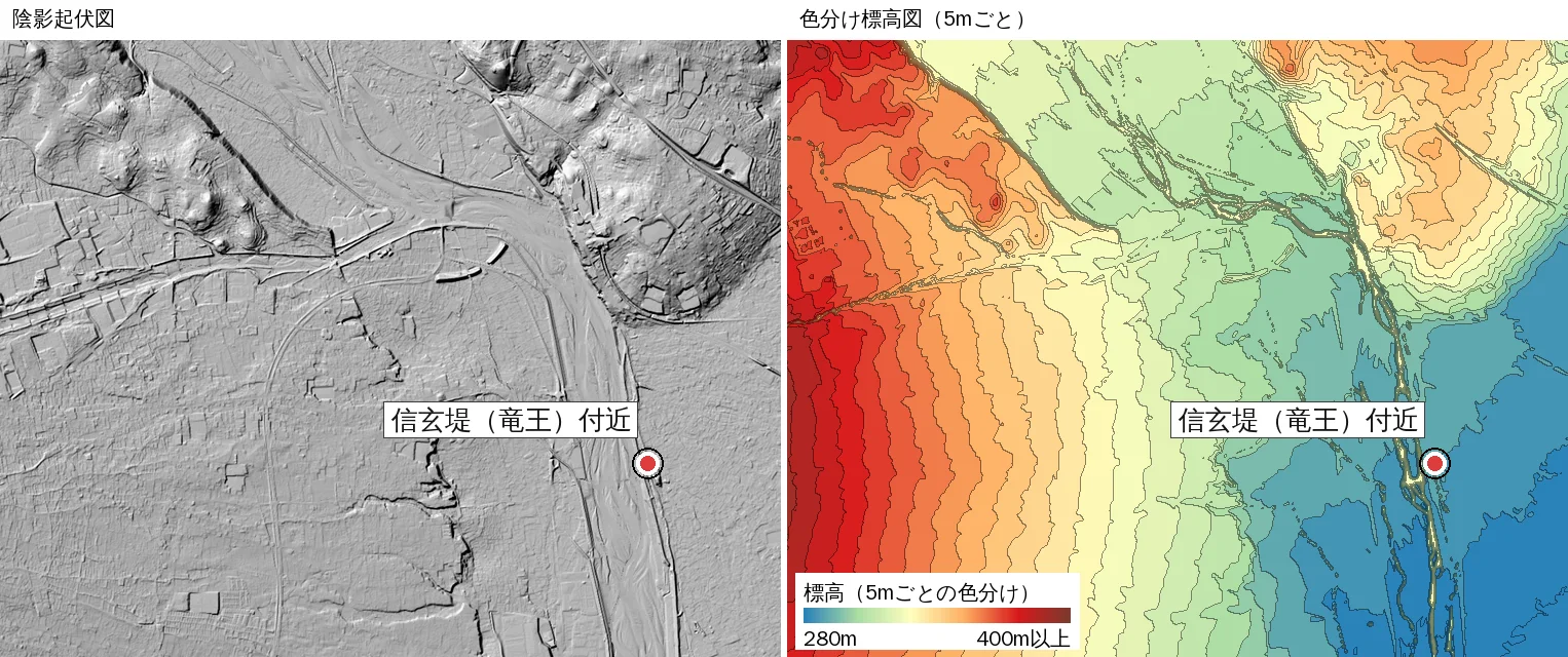
In the colored elevation, the western (left) mountain side is in warm colors and the Kamanashi riverside in the east (right) is in cool colors, falling gently from nearly 400 m to about 285 m. This large slope appears to be the fan built by the Mikuri River. In the hillshade, traces of old river courses remain on the fan as streaks.
Water coming down the steep fan meets the Kamanashi still carrying its force and reaches the flat of the basin just beyond Ryuo. From the terrain, it seemed to us that Shingen's flood control was about where to take that force and where to weaken it.
Zooming in on the Ryuo levee
Next, a close-up of the Shingen Levee area in Ryuo, with elevation colored every 1 m.
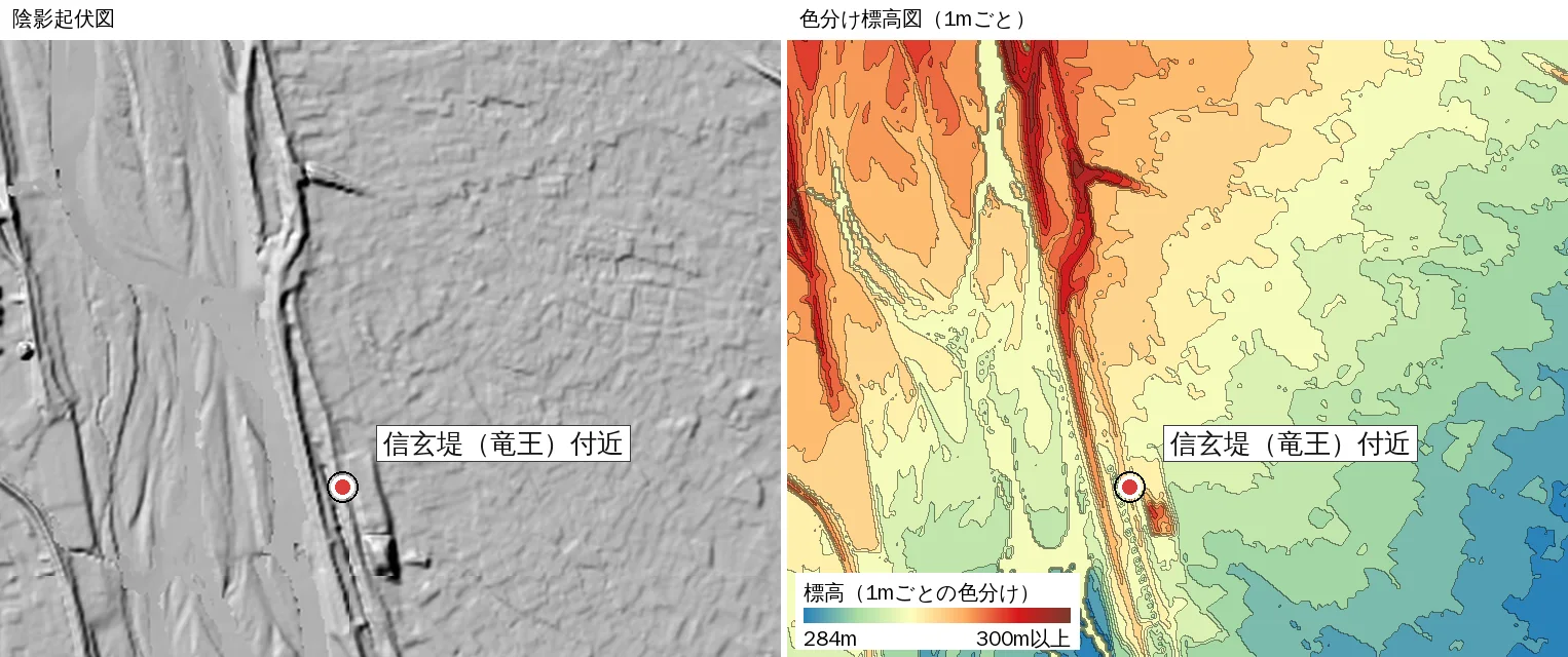
In the hillshade, a nearly straight rise follows the east bank of the Kamanashi River. In the colored elevation it becomes a thin warm-colored band, and the flat land to the east shifts from yellow to green to blue as it falls.
As a rough estimate from elevation data, the top of the levee here stands about 2 to 5 m above the flat land just to the east. About 700 m east of the river, the ground drops by around 4 to 5 m. In places the river bed therefore runs higher than the flat land outside the levee. These are approximations read from GSI's 5 m mesh elevation data, not guaranteed heights.
What you see here is the present levee. According to Kai City, the Shingen Levee has been handed down through repeated repairs, and its form changed in major works from the mid-Meiji period onward. It is not the exact form of the time; we take it as a levee that carries on the basic concept.
Meiji-era paddies and Kai City today
"Even if it is housing now, it must have been paddies once." We compared Meiji-era wetlands with a current aerial photo.
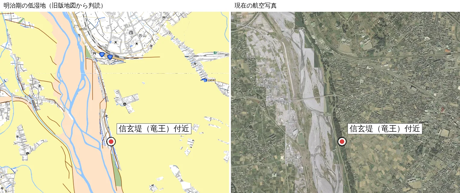
The left map is GSI's reading of wetlands from old Meiji-era maps. Most of the flat land east of the levee is painted yellow (paddies and other wetlands), with only small villages left white. In the current aerial photo on the right, the same area is filled with housing and fields. You can see that many former paddies have become housing and roads.
In the aerial photo, a belt of trees runs along the levee. MLIT's material says Shingen had trees planted near embankments, and it was striking to see this overlap with today's view. Of course, today's trees are not necessarily those of the time.
Meiji villages and assumed flooding
We also placed Meiji-era land use next to the flood-depth assumption (maximum scale) published by the national government.
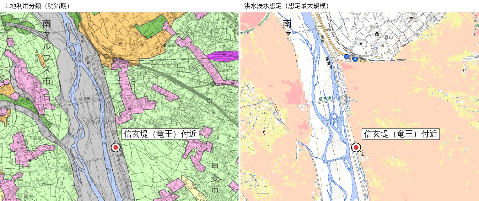
In the Meiji land use on the left, villages (pink) lie in a thin band along the river and scattered through the fields to the east. In the flood-depth assumption on the right, a wide area east of the levee is painted pale orange (0.5 to 3 m). It is a worst-case assumption for when a levee breaks or rain exceeds expectations.
Because the embankments that continue from the Shingen Levee have held back the Kamanashi's water, fields and then housing have spread to the east. The levee protects life to this day, but the extent of protected land is also the extent that water could reach "just in case". The flood-depth map seems to teach both the importance of the levee and a reason to think about preparedness.
What a static, flat map hides
The figures above are hard to notice from a paper map or an ordinary map service screen alone.
- The height relation between the river and the flat land outside the levee is not visible on a flat map.
- That Meiji-era paddies are now housing is not visible on a current map alone.
- That a wide area east of the levee falls within the flood assumption becomes tangible only once colors are overlaid.
With MAPRISE, you can line up hillshade, colored elevation, Meiji-era wetlands and land use, flood-depth assumptions and aerial photos at the same place through layer switching and split view. With a few clicks, the link between a 400-year-old idea and today's life comes into view. That was our impression this time.
Lord Shingen's great achievement
Shingen left his name as a leading Sengoku warlord. But looking at the Shingen Levee on a map, what stayed with us was that he built the national strength behind his victories through work with the rivers, and that this work has kept protecting our lives for more than 450 years since.
Beyond making his name as a warlord, building flood control and water use that serves later generations may be Lord Shingen's great achievement. If you visit Ryuo, remember the shape of the land you saw on the map and walk along the levee.
About the data
- The figures were created from the same GSI and MLIT data MAPRISE uses.
- The hillshade is GSI's hillshade; the colored elevation is based on GSI's 5 m mesh elevation (DEM5A).
- Meiji-era wetlands are from GSI; land use classification (Meiji era) is from MLIT's land classification survey; the flood-depth assumption is from MLIT's Hazard Map Portal (maximum scale); the aerial photo is GSI's latest nationwide photo.
- The marker shows an approximate position of the Shingen Levee. Please check Kai City and other official materials for exact extents.
- Height differences are approximations read from the 5 m mesh elevation and are not guaranteed.
- The construction date, period and scale vary by source, and the attribution to Shingen includes tradition.
- We could not confirm the cultural-property designation status of the Shingen Levee itself. The national historic site is the old Mikuri River embankments, including Shogi-gashira and the stone-pile spurs.
- The flood-depth assumption is reference information. For disaster-prevention decisions, please also check the hazard maps published by the municipality.
Closing
Change the map, and the same land shows a different face. This time we looked at a levee built by a Sengoku commander from three viewpoints: elevation, Meiji-era land, and present-day life. We would like to look for other famous levees and old flood-control sites too.
Questions or feedback are welcome at info@maprise.jp.
Sources
- Shingen Levee (Kai City)
- Shingen Levee map picture (Kai City)
- Old Mikuri River embankments, Shogi-gashira and stone-pile spurs (Cultural properties of Yamanashi)
- Rivers of Japan: Fuji River (MLIT)
- Shingen Levee (Yamanashi tourism)
- Maps and data: Hillshade, elevation, Meiji-era wetlands and aerial photos (GSI); Flood-depth assumption, maximum scale (MLIT Hazard Map Portal) (processed and displayed in MAPRISE; providers and licenses are listed on our Data sources page, and the data you can view on the map on our Layer catalogue)
Tags: #Shingen Levee #Takeda Shingen #flood control #water use #Kai City #Ryuo #Kamanashi River #Mikuri River #hillshade #colored elevation #Meiji-era wetlands #flood depth #Sengoku period
Other-language share text (exception cases)
Quick share above follows our platform-locked language policy (X-family in Japanese, LinkedIn in English). The four panes below let you grab the opposite-language body when needed — e.g. introducing an English post to a Japanese audience on X, or posting a Japanese article to LinkedIn in Japanese. Each pane offers both a copy button and a direct intent link.
📝 武田信玄の治水と信玄堤を地図で読む ― 竜王の地形、明治期の田んぼ、いまの甲斐市を重ねて(MAPRISE)
戦国の「甲斐の虎」武田信玄は、治水・利水でも名を残しました。山梨県甲斐市の信玄堤を、MAPRISEと同じ国土地理院等のデータによる陰影起伏図・色分け標高図・明治期の低湿地・土地利用・洪水浸水想定・航空写真で見比べ、堤が守ってきた土地のかたちを探します。
https://maprise.jp/ja/blog/shingen-zutsumi/ #信玄堤 #武田信玄
🆕 新しいブログ記事を公開しました。

《武田信玄の治水と信玄堤を地図で読む ― 竜王の地形、明治期の田んぼ、いまの甲斐市を重ねて(MAPRISE)》

戦国の「甲斐の虎」武田信玄は、治水・利水でも名を残しました。山梨県甲斐市の信玄堤を、MAPRISEと同じ国土地理院等のデータによる陰影起伏図・色分け標高図・明治期の低湿地・土地利用・洪水浸水想定・航空写真で見比べ、堤が守ってきた土地のかたちを探します。

👉 詳しくはこちら: https://maprise.jp/ja/blog/shingen-zutsumi/
📝 Reading Takeda Shingen's Flood Control and the Shingen Levee on a Map ― Ryuo's Terrain, Meiji-Era Paddies and Kai City Today (MAPRISE)
Takeda Shingen, the 'Tiger of Kai', left his mark on flood control and water use as w…
https://maprise.jp/en/blog/shingen-zutsumi/ #ShingenLevee #TakedaShingen
🆕 New on the MAPRISE blog.

《Reading Takeda Shingen's Flood Control and the Shingen Levee on a Map ― Ryuo's Terrain, Meiji-Era Paddies and Kai City Today (MAPRISE)》

Takeda Shingen, the 'Tiger of Kai', left his mark on flood control and water use as well as on the battlefield. Using hillshade, colored elevation, Meiji-era wetlands, land use, flood-depth assumptions and aerial photos from the same data MAPRISE uses, we looked at the Shingen Levee in Kai City, Yamanashi.

👉 Read the full post: https://maprise.jp/en/blog/shingen-zutsumi/

#ShingenLevee #TakedaShingen #floodcontrol #wateruse #KaiCity
Related posts
- Can We Still See the Dam of the Bitchu Takamatsu Water Attack on a Map? ― Looking for Kuroda Kanbei's Embankment in MAPRISE, 440 Years On2026-10-13
- Reading Chiba's Flooded Areas with MAPRISE Layers — Meiji-Era Wetlands, Geology, Elevation, and Official Hazard Maps2026-10-12
- Chasing the Hizen Moat sleeping beneath Tenjin, with MAPRISE's old-map layers2026-07-11