Bitchu Takamatsu Castle is famous for the water attack of 1582, said to have been proposed by Kuroda Kanbei. Does the embankment built then still show on a map? We plotted the castle site and the Kawazugahana embankment remains on a trial-development screen of MAPRISE (a hillshade and a colored contour map planned as a future layer) to find out.
Hello, this is the MAPRISE development team. This time we check one of the Sengoku period's famous episodes, the water attack on Bitchu Takamatsu Castle, against the map.
Surrounding a castle with water to isolate it was a bold plan, said to have been proposed by Kuroda Kanbei (Kuroda Yoshitaka). Can the embankment built then still be found on a map, about 440 years later? We looked for it using a hillshade and a colored contour map, shown here from a trial-development screen of MAPRISE, with the colored contour layer planned for future implementation.
What was the water attack on Takamatsu Castle?
In 1582 (Tensho 10), Hashiba Hideyoshi (later Toyotomi Hideyoshi) besieged Bitchu Takamatsu Castle (now Kita Ward, Okayama City), held by Shimizu Muneharu for the Mori clan. The castle stood on flat ground but was protected by marshes that acted as a natural moat, and is said to have been considered impregnable.
Hideyoshi therefore chose a "water attack": enclose the castle with an embankment and bring in river water to flood it. The plan is said to have come from Kuroda Kanbei. The embankment is said to have been built in only about 12 days, and with the rainy season, the surroundings became like a lake.
Soon after, Hideyoshi learned of the Honnoji Incident (the death of Oda Nobunaga) and made peace with the Mori; Shimizu Muneharu took his own life in exchange for the lives of the garrison. It is one of the turning points leading to Hideyoshi's famous rapid return east.
Sources differ on the embankment's size: roughly 2.6 to 3 km long and 5 to 7 m high. Okayama City's guide gives about 2,600 m in length and about 6.5 m in height, running between Kawazugahana and Monzen.
Plotting the castle site and the embankment remains
First we plotted the castle site and the Kawazugahana embankment remains, where part of the embankment is said to survive, on a map. The figures below are trial-development screens of MAPRISE (not yet released). On the left is a black-and-white hillshade; on the right is a contour map with each elevation band in its own color. Fine-pitch colored contour maps such as 2 m or 0.5 m are not yet a released layer; we expect to implement them as a future layer.
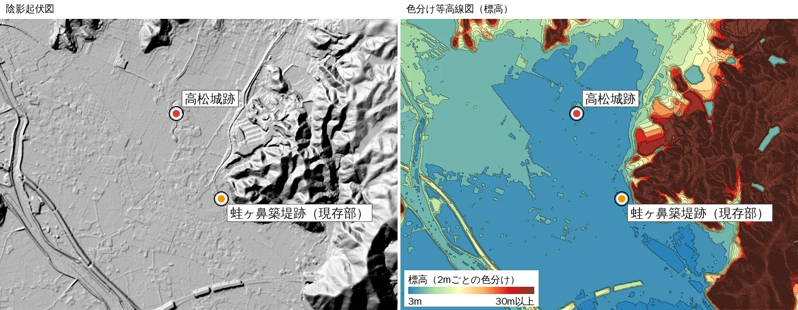
In the contour map, the castle site sits in blue, the lowest color. Hills, shifting from green to red and brown, enclose it on the north and east. Flat ground at about 4 to 5 m above sea level spreads around it.
We think this was well suited to holding water. The people of 400 years ago may have chosen the place for the water attack by reading this very terrain.
Finding the Kawazugahana embankment in the hillshade
Next we zoom in on the Kawazugahana embankment remains.
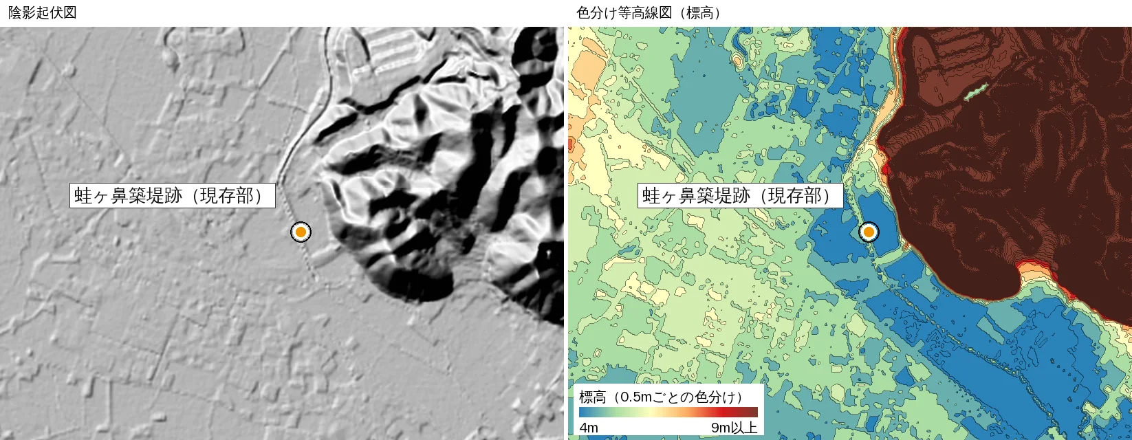
In the hillshade, a thin line extends from where the hillslope ends into the flat ground. It is broken like a dotted line and runs for about 300 m. Since the surroundings are almost flat fields and housing, we think this is a rise piled up by human hands.
In other words, an embankment from over 400 years ago remains as a trace in the terrain.
Reading the height in the colored contour map
How high is this embankment? In the contour map colored every 0.5 m, the surrounding flat ground is about 4.3 m, while the embankment remains are about 5.3 m, a difference of roughly 1 m. This is an approximation read from GSI's 5 m mesh elevation data and is not a guaranteed height.
Compared with the height said to have been built (around 6.5 m), it is much lower. Over the centuries it was probably cut away for fields and roads, or eroded by wind and rain. A document from Okayama Prefecture also notes that only a small part of the embankment survives.
Even so, a rise of only about 1 m stands out clearly as a line in the hillshade, and in the colored contour map it can be read as a difference of color in 0.5 m steps.
The area around the castle site
Finally, we zoom in on the castle site.
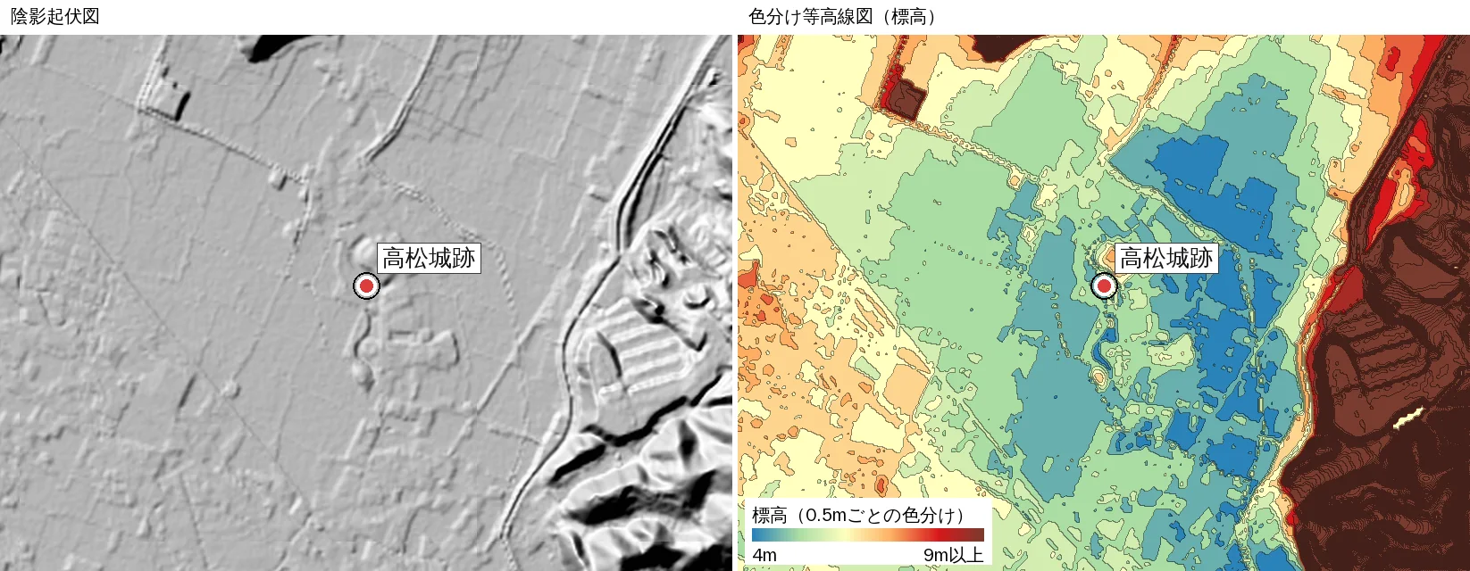
Around the castle site, the contour map shows blue to light blue, one of the lowest spots in the area. Even if the height difference is small, the change of color shows the land sloping gently toward the lower ground. From this color difference, we think it can be read that the castle stood where water collects easily.
What is hard to see on a static, flat map
Little of the above is easy to notice from a paper map or an ordinary map service screen.
- A rise of about 1 m is almost invisible on a flat map.
- Without color, you cannot tell 4 m from 5 m.
- The extent of "land lower than its surroundings" is hard to feel unless you count contour lines one by one.
Once the colored contour map is implemented as a future layer, we hope MAPRISE will let you switch layers at the same location and compare the hillshade, the colored contour map and the standard map. Split view puts two maps side by side at the same position and scale. We expect that, with just a few clicks, the traces of the 400-year-old embankment and the shape of the low ground where the castle stood will come into view (currently in trial development).
Before you visit, check MAPRISE
The Kawazugahana embankment remains and the castle site are maintained as historic site parks. Checking the terrain on the map before you go may let you enjoy the land itself as you walk: "this is around the embankment," "the castle sat a step lower."
Beyond castles and battlefields, differences in ground height bear directly on modern land selection and disaster prevention. MAPRISE is a map service for real-estate site evaluation and due diligence, and we would be glad if you also used it to read historic land.
About the data
- The figures in this article are trial-development screens of MAPRISE. They differ from the released layers, are expected to be implemented as a future layer, and their specifications and appearance may change.
- The figures were created from the same Geospatial Information Authority of Japan (GSI) data that MAPRISE uses.
- The hillshade is GSI's hillshade; the colored contour map is based on GSI's 5 m mesh elevation (DEM5A).
- The castle and embankment markers show approximate positions. Please check official materials from Okayama City and others for exact extents.
- The embankment's length, height and construction period vary by source. Some recent studies suggest a smaller embankment than previously thought would have been enough to flood the castle's surroundings, and research is expected to continue.
- Height differences are approximations read from the 5 m mesh elevation and are not guaranteed.
- Kuroda Kanbei's proposal is as passed down in later war chronicles; details of the historical facts are debated.
Closing
Change the map, and the same land shows a different face. This time we looked at the stage of a battle some 440 years ago in a hillshade and a colored contour map. We would like to try other battlefields and castle sites too.
Questions or feedback are welcome at info@maprise.jp.
Sources
- Takamatsu Castle Site with Water-Attack Embankment Remains (Okayama Prefecture)
- Takamatsu Castle water attack embankment remains (Okayama City)
- Takamatsu Castle's water attack and the Nagano River water-magistrate site (Okayama City / Okayama City Museum)
- The water attack on Bitchu Takamatsu Castle (Tabi-mag)
- Maps and data: Hillshade and elevation tiles (GSI) (processed and displayed in MAPRISE; providers and licenses are listed on our Data sources page, and the data you can view on the map on our Layer catalogue)
Tags: #Bitchu Takamatsu Castle #water attack #Kuroda Kanbei #Kawazugahana embankment #hillshade #colored elevation #contour #Okayama #Sengoku period #terrain
Other-language share text (exception cases)
Quick share above follows our platform-locked language policy (X-family in Japanese, LinkedIn in English). The four panes below let you grab the opposite-language body when needed — e.g. introducing an English post to a Japanese audience on X, or posting a Japanese article to LinkedIn in Japanese. Each pane offers both a copy button and a direct intent link.
📝 備中高松城の水攻めの堰は、今も地図で確認できるのか ― 黒田官兵衛の献策から440年、MAPRISEで探してみた
天正10年(1582年)、黒田官兵衛の献策と伝えられる水攻めで知られる備中高松城。そのとき築かれた堤は、いまも地図の上に残っているのでしょうか。MAPRISEの試験開発中の画面(将来のレイヤーとして実装を見込む色分け等高線図と陰影起伏図)に、高松城跡と蛙ヶ鼻築堤跡をプロットして確かめてみました。
https://maprise.jp/ja/blog/bitchu-takamatsu-mizuzeme/ #備中高松城 #水攻め
🆕 新しいブログ記事を公開しました。

《備中高松城の水攻めの堰は、今も地図で確認できるのか ― 黒田官兵衛の献策から440年、MAPRISEで探してみた》

天正10年(1582年)、黒田官兵衛の献策と伝えられる水攻めで知られる備中高松城。そのとき築かれた堤は、いまも地図の上に残っているのでしょうか。MAPRISEの試験開発中の画面(将来のレイヤーとして実装を見込む色分け等高線図と陰影起伏図)に、高松城跡と蛙ヶ鼻築堤跡をプロットして確かめてみました。

👉 詳しくはこちら: https://maprise.jp/ja/blog/bitchu-takamatsu-mizuzeme/
📝 Can We Still See the Dam of the Bitchu Takamatsu Water Attack on a Map? ― Looking for Kuroda Kanbei's Embankment in MAPRISE, 440 Years On
Bitchu Takamatsu Castle is famous for the water attack of 1582, said to hav…
https://maprise.jp/en/blog/bitchu-takamatsu-mizuzeme/ #BitchuTakamatsuCastle #waterattack
🆕 New on the MAPRISE blog.

《Can We Still See the Dam of the Bitchu Takamatsu Water Attack on a Map? ― Looking for Kuroda Kanbei's Embankment in MAPRISE, 440 Years On》

Bitchu Takamatsu Castle is famous for the water attack of 1582, said to have been proposed by Kuroda Kanbei. Does the embankment built then still show on a map? We plotted the castle site and the Kawazugahana embankment remains on a trial-development screen of MAPRISE (a hillshade and a colored contour map planned as a future layer) to find out.

👉 Read the full post: https://maprise.jp/en/blog/bitchu-takamatsu-mizuzeme/

#BitchuTakamatsuCastle #waterattack #KurodaKanbei #Kawazugahanaembankment #hillshade
Related posts
- Reading Takeda Shingen's Flood Control and the Shingen Levee on a Map ― Ryuo's Terrain, Meiji-Era Paddies and Kai City Today (MAPRISE)2026-10-13
- Don't Choose a Cliff-Top Home on View and Elevation Alone: Retaining Walls, Disclosure Rules, Land Prices and Yellow Zones, City by City (Part 2)2026-10-25
- Did the Rich Move Uphill to Avoid Floods? Testing 'Yamanote vs Shitamachi' in Tokyo, Nagoya, Osaka and Fukuoka with Four Maps2026-10-24