The "Stone-Paved Plaza" in the Tenjin underground mall quietly carries the memory of the Hizen Moat — a 50-meter-wide canal that once ran east-west between Fukuoka Castle and Tenjin. A map-and-history-obsessed developer went chasing its traces, overlaying the Meiji-era wetland and land-use layers along the way.
I'll come clean: I'm a map-and-history nerd through and through. Even off the clock, overlaying an old map on today's city and wondering "what used to be here?" is basically a hobby of mine. This post starts as a purely personal detour, but it led somewhere that connects directly to what MAPRISE does — so I wanted to write it up for the development blog.
It started with a stone wall in the Tenjin underground mall
Walking through the Tenjin underground shopping mall, there's a stretch between Block 7 and Block 8 where the walls are built up like a European castle wall — stacked stone. It's known as the "Stone-Paved Plaza." I'd walked past it plenty of times, but one day I actually stopped to look, and noticed a small plaque off to the side.
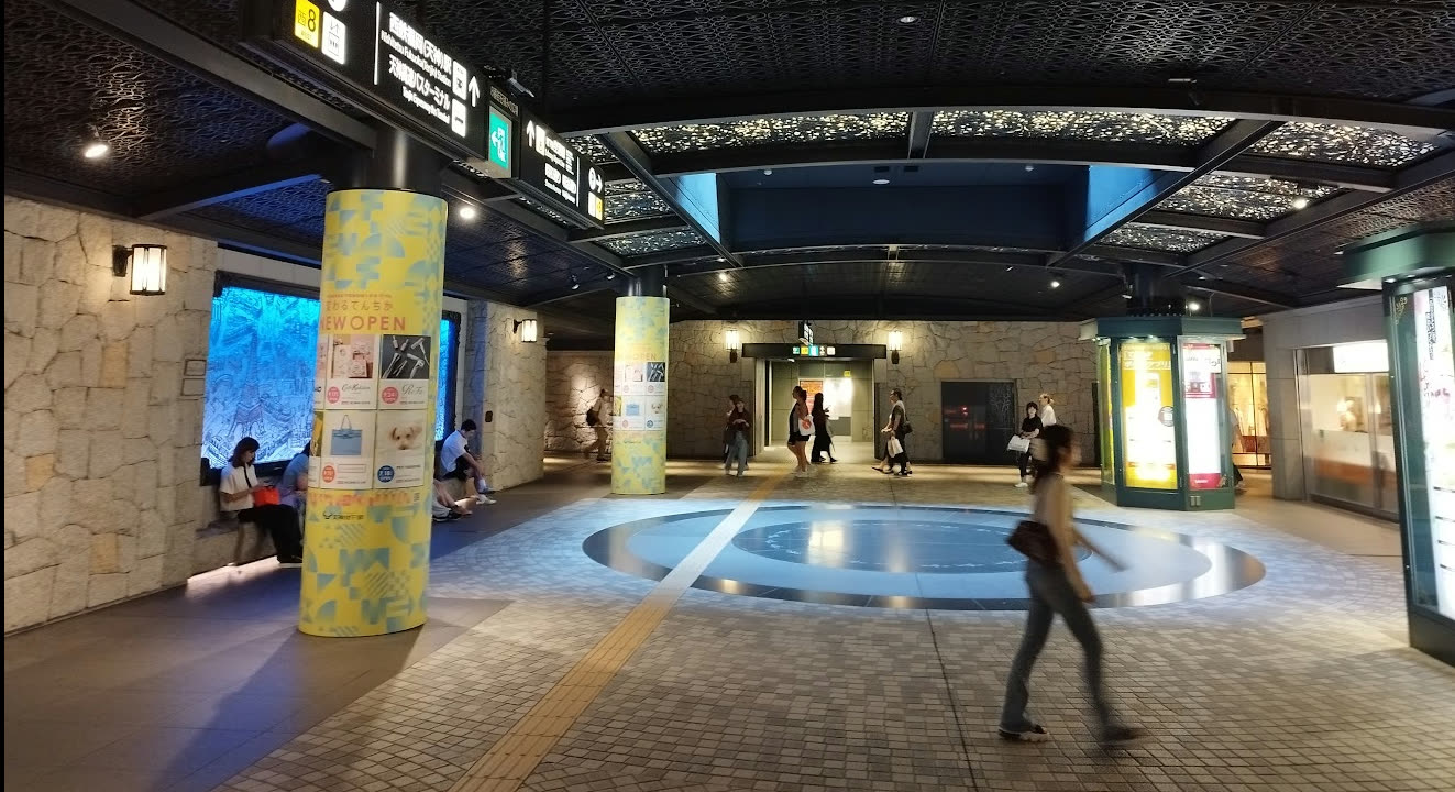
Here's what the plaque said:
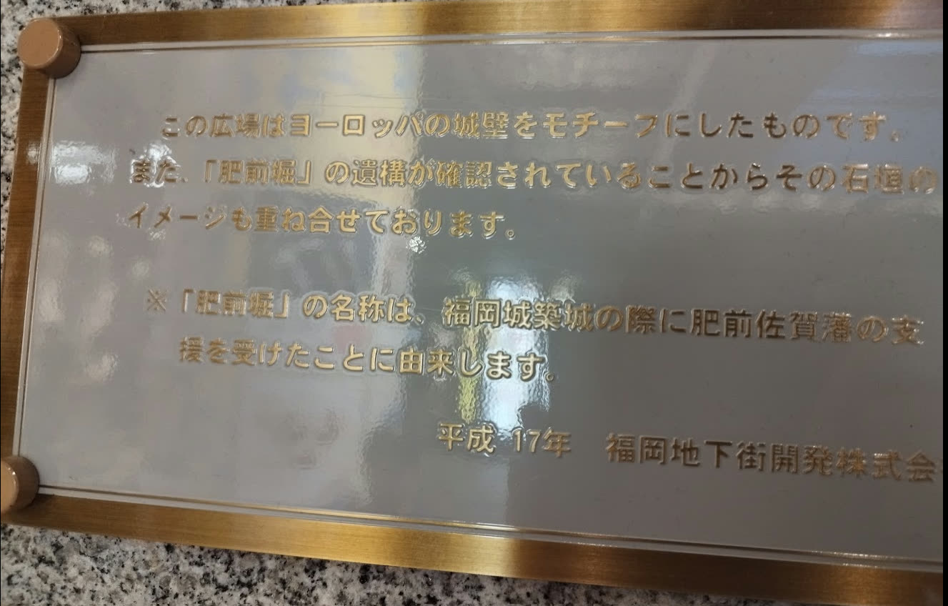
This plaza is modeled on European castle walls. It also layers in the image of the stone ramparts confirmed to belong to the remains of the "Hizen Moat" (Hizen-bori).
"Hizen Moat" — a name I'd heard before, but never really looked into. So I looked it up, and it turned out to be a genuinely interesting story.
What was the Hizen Moat?
The Hizen Moat was a 50-meter-wide canal built during the Edo period, alongside the construction of Fukuoka Castle, running east-west directly through what is now the heart of Tenjin. At first, its north and south banks had no stone ramparts, and heavy rains repeatedly caused the embankments to collapse — until, in 1811 (Bunka 8), stone ramparts were finally built, according to the historical record.
The origin of the name turned out to be just as interesting. "Hizen" refers to the neighboring Hizen Saga Domain. The Nabeshima clan that ruled Saga had sided with the western army at the Battle of Sekigahara — a position that could easily have brought harsh punishment — but they were spared by Ieyasu, in part on the advice of Kuroda Josui of the neighboring Fukuoka Domain. Out of gratitude for that, the Saga Domain reportedly took on the moat construction work for Fukuoka Castle — this very Hizen Moat. It's a small reminder that behind the history of a castle and its castle town sits a whole web of debts and favors between domains — I found that genuinely charming.
The Hizen Moat was later filled in, in 1910 (Meiji 43), to make way for an industrial exposition. The southern half of today's Fukuoka City Hall building reportedly sits directly on the former moat's footprint. The "Stone-Paved Plaza" in the Tenjin underground mall was designed the way it was because the actual stone-rampart remains of the Hizen Moat were confirmed during later construction work — and that discovery was layered together with the image of a European castle wall. Beneath the feet of everyone casually walking through that underground mall, it turns out, sleeps the memory of an Edo-period moat.
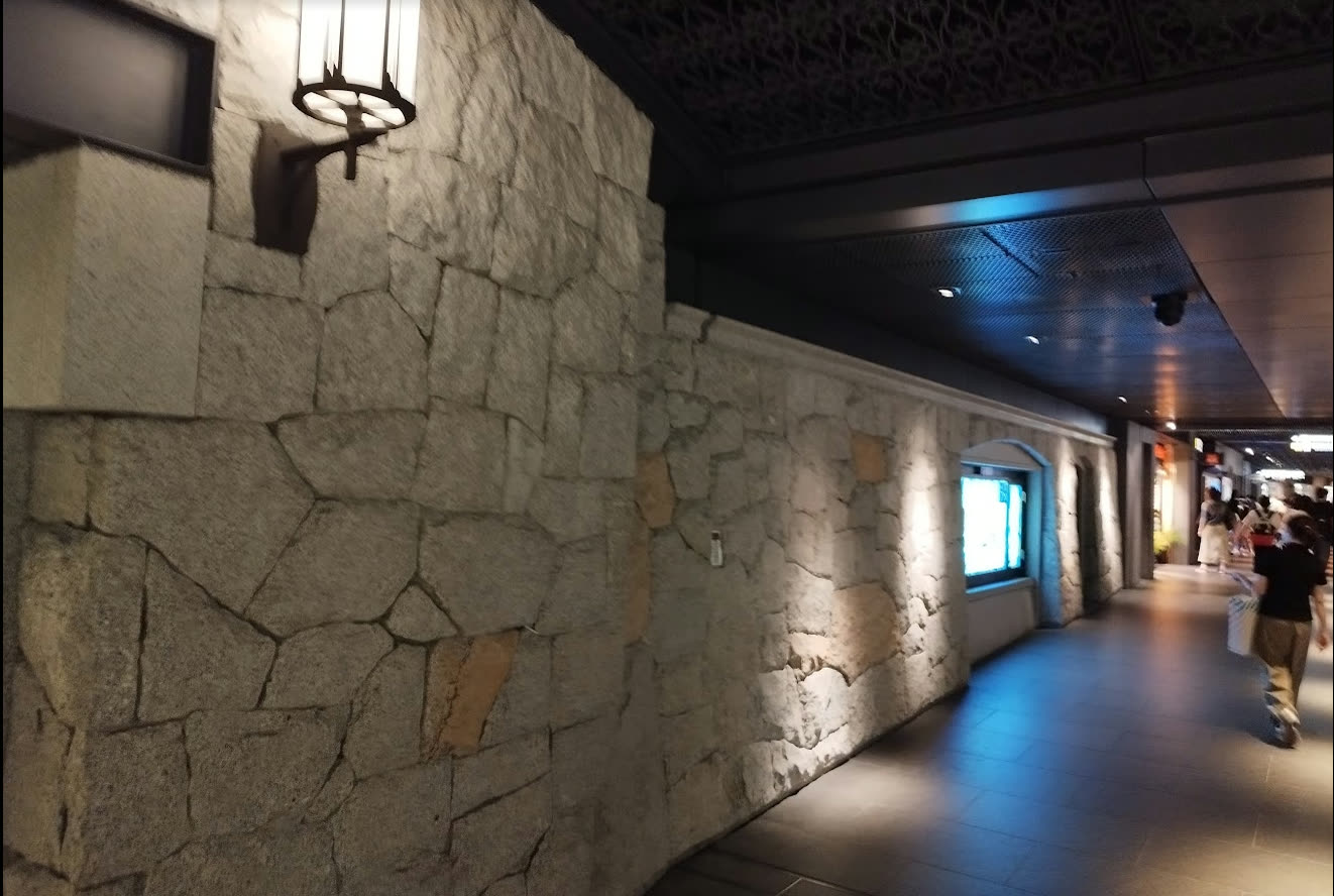
Looking at the same spot through MAPRISE's old-map layers
Here's where it comes back to MAPRISE. I used the split-screen feature to compare the area where the Hizen Moat once ran, through two historical map layers.
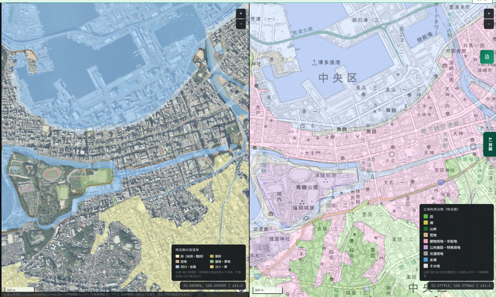
The left side overlays aerial imagery with the "Meiji-era Wetlands" layer. Built from old-edition maps published by the Geospatial Information Authority of Japan, it shows areas that were wetland, paddy field, or riverbank during the Meiji era — color-coded by category: paddy field (wet/dry), muddy ground, rivers/waterways, marsh/grassland, deep paddy, reed/thatch land. Former wetlands tend to have soft ground prone to liquefaction, which is why this layer is also useful for assessing seismic ground risk (it's only available for major plains).
The right side overlays a standard map with the "Land-use Classification (Meiji era)" layer. The area around the Fukuoka Castle ruins and Maizuru Park is coded as public/special-use land (purple), while the Tenjin area just to the east is coded as building land / urban district (pink). Just from the color distribution, you can see that the foundation of today's bustling Tenjin already had the shape of an urban district back in the Meiji era.
The Hizen Moat itself predates both of these layers — it's an Edo-period structure, older than the Meiji-era snapshots shown here — but overlaying these layers is a genuinely fun way to gradually read how the water infrastructure and terrain of a castle town got etched into this particular stretch of ground.
The value of knowing "what used to be here"
Overlaying an old map on today's map isn't just a history buff's indulgence. Whether a piece of land was once a paddy field, a wetland, or already an urban district by the time of the Meiji era — knowing how that land came to be is a quiet clue for thinking about the buildings and lives sitting on it today.
Alongside these old-map layers, MAPRISE also provides geological maps and other ground-related data. For a given point, you can layer what the land used to be (qualitative information) together with figures for ground strength and disaster risk (quantitative information). And if you ask the AI chat something like "what's the ground risk at this location?", it's set up to support an answer drawing on exactly this kind of combined information.
An ordinary walk through the Stone-Paved Plaza, and one extra map layer later, you're connected to the memory of a moat more than 350 years old. I hope to keep delivering that kind of experience through MAPRISE. For another round of digging up history through maps, see chasing the Mizuki earthwork that once defended Dazaifu.
The historical account of the Hizen Moat in this article is based on information published by Fukuoka City and the on-site plaque at the "Stone-Paved Plaza" in the Tenjin underground mall (installed in 2005). The old-map layers (Meiji-era Wetlands, Land-use Classification) are derived from public data published by the Geospatial Information Authority of Japan and MLIT, and may differ from actual terrain and boundaries, including in positional accuracy.
Source: Fukuoka City, "The Hizen Moat and the Stone-Paved Plaza"; on-site plaque at the Tenjin underground mall (installed 2005); Geospatial Information Authority of Japan (Meiji-era old-edition maps, basic land classification survey)
Tags: #Hizen Moat #Fukuoka Castle #Tenjin underground mall #Meiji-era wetlands #Ground
Other-language share text (exception cases)
Quick share above follows our platform-locked language policy (X-family in Japanese, LinkedIn in English). The four panes below let you grab the opposite-language body when needed — e.g. introducing an English post to a Japanese audience on X, or posting a Japanese article to LinkedIn in Japanese. Each pane offers both a copy button and a direct intent link.
📝 天神の地下に眠っていた「肥前堀」を、MAPRISEの古地図レイヤーで追いかけてみた
天神地下街の「石積みの広場」は、かつて福岡城と天神の間を東西に流れていた幅50mの堀「肥前堀」の記憶を今に伝えています。明治期の低湿地・土地利用分類レイヤーを重ねながら、地図好き・歴史好きの開発者が、その痕跡を追いかけてみました。
https://maprise.jp/ja/blog/hizen-bori-history/ #肥前堀 #福岡城
🆕 新しいブログ記事を公開しました。

《天神の地下に眠っていた「肥前堀」を、MAPRISEの古地図レイヤーで追いかけてみた》

天神地下街の「石積みの広場」は、かつて福岡城と天神の間を東西に流れていた幅50mの堀「肥前堀」の記憶を今に伝えています。明治期の低湿地・土地利用分類レイヤーを重ねながら、地図好き・歴史好きの開発者が、その痕跡を追いかけてみました。

👉 詳しくはこちら: https://maprise.jp/ja/blog/hizen-bori-history/
📝 Chasing the Hizen Moat sleeping beneath Tenjin, with MAPRISE's old-map layers
The "Stone-Paved Plaza" in the Tenjin underground mall quietly carries the memory of the Hizen Moat — a 50-meter-wide canal that once ran east-we…
https://maprise.jp/en/blog/hizen-bori-history/ #HizenMoat #FukuokaCastle
🆕 New on the MAPRISE blog.

《Chasing the Hizen Moat sleeping beneath Tenjin, with MAPRISE's old-map layers》

The "Stone-Paved Plaza" in the Tenjin underground mall quietly carries the memory of the Hizen Moat — a 50-meter-wide canal that once ran east-west between Fukuoka Castle and Tenjin. A map-and-history-obsessed developer went chasing its traces, overlaying the Meiji-era wetland and land-use layers along the way.

👉 Read the full post: https://maprise.jp/en/blog/hizen-bori-history/

#HizenMoat #FukuokaCastle #Tenjinundergroundmall #Meiji-erawetlands #Ground