We've implemented an active-fault layer based on Japan's Geospatial Information Authority (GSI) 'Urban Area Active Fault Maps.' Using the Futagawa Fault Zone (source of the 2016 Kumamoto earthquake), the Kego Fault running through central Fukuoka, the Uemachi Fault Zone that shaped Osaka's Uemachi Plateau, and the Tachikawa Fault Zone as examples, here's how to read the layer and how it relates to real-estate disclosure.
Hello from the MAPRISE team. This time we're introducing an active-fault layer based on the Geospatial Information Authority of Japan's (GSI) "Urban Area Active Fault Maps." We've set the map background to a plain white base so the fault lines and terrain relief stand out clearly.
What an active fault is, and what the Urban Area Active Fault Maps are
An active fault is one that has moved repeatedly in the recent geological past — roughly the last several hundred thousand years — and is considered likely to move again in the future. GSI began compiling its "Urban Area Active Fault Maps" after the 1995 Great Hanshin-Awaji Earthquake; as of December 2024, 249 map sheets have been published nationwide. They cover Japan's major urban areas at a 1:25,000 scale, showing fault locations and how confidently each one has been identified.
The legend uses the following color and line-style coding.
- Active fault (location well-defined): solid red line
- Active fault (location somewhat unclear) / inferred active fault: dashed red line
- Active fault (concealed section): dotted red line — a section covered by newer sediment layers, where no surface offset is currently visible
- Active fault, submarine (sea/lake floor): solid green line
- Active fault (monoclinal flexure): a band that appears not as a sharp surface offset but as a gentle warp; the arrow shows the direction of tilt
The background coloring is a "terrain classification," divided into three tiers: upper terrace (land that emerged from water roughly several hundred thousand years ago), middle terrace (roughly 100,000 to tens of thousands of years ago), and lower terrace (roughly tens of thousands to several thousand years ago). This isn't just background information — it's closely tied to the fault activity itself. Many active faults are reverse faults, and with each earthquake, one side of the ground is lifted slightly relative to the other. Accumulated over tens or hundreds of thousands of years, that repeated uplift is what creates a "terrace" or "plateau" landform standing above its surroundings. In other words, this terrain classification is itself a record of how much a fault has moved over time.
Try it: Kumamoto — the Futagawa Fault Zone (wide view)
Here's what it looks like when you display Kumamoto Prefecture in MAPRISE.
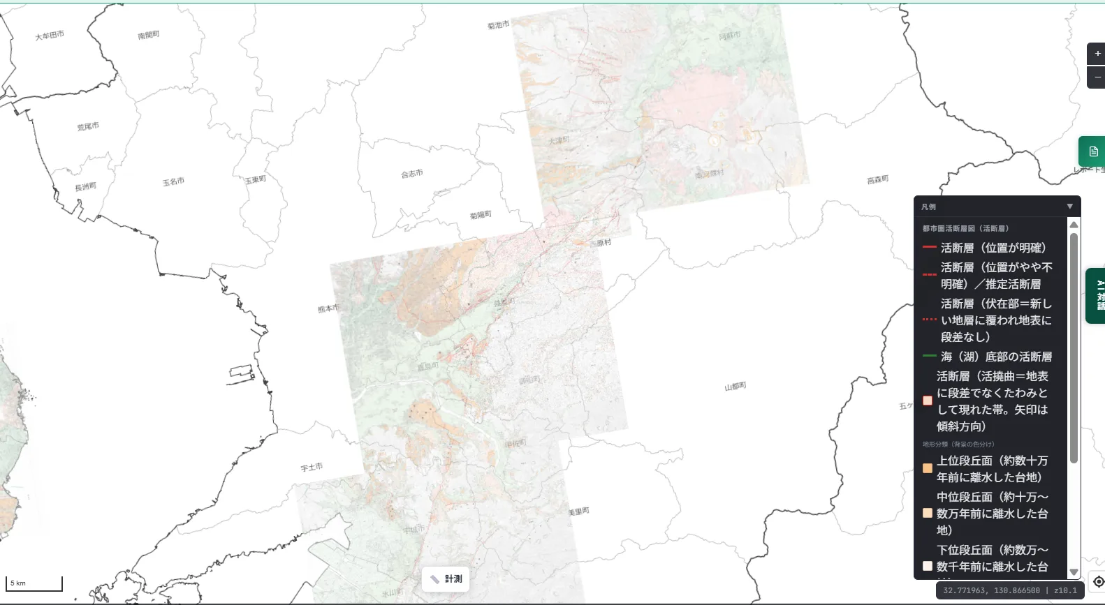
Running from the southwestern foot of the Aso caldera rim toward the Kumamoto Plain is the Futagawa Fault Zone — known as the source fault of the main shock (M7.3) of the 2016 Kumamoto earthquake.
Try it: Kumamoto — zoomed into central Mashiki Town
Zooming into central Mashiki Town — directly above the source fault itself — the impression changes considerably.
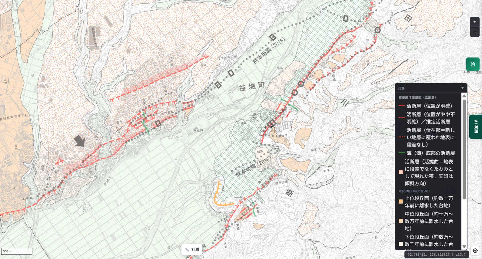
You can see the solid red line cutting diagonally across the residential grid and roads, indifferent to property lines. This is the fault that actually ruptured the surface in the 2016 Kumamoto earthquake, producing roughly 2 meters of horizontal displacement in Mashiki Town. Part of this surface rupture was designated a national Natural Monument in 2018 and has since been preserved as a site that conveys the memory of the disaster. On the map it's just a single line, but this close-up view makes clear that real people were living directly above it.
Try it: Fukuoka — the Kego Fault
Here's what it looks like around Fukuoka City.
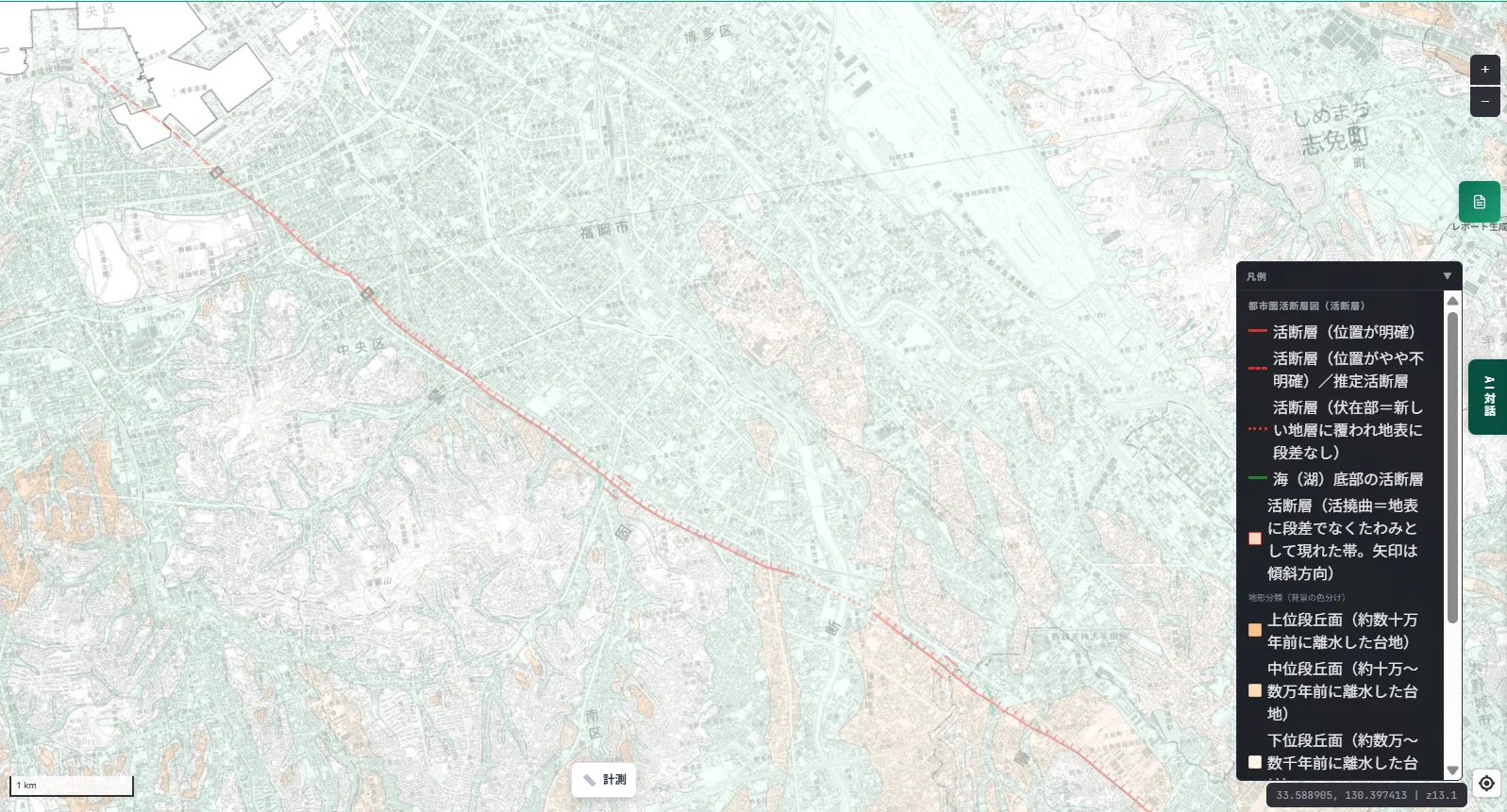
The Kego Fault Zone runs roughly 55 km from Hakata Bay through Fukuoka City's Chuo and Minami wards to Kasuga, Onojo, Dazaifu, and Chikushino, in a northwest-southeast direction. As the map shows, it passes directly beneath Fukuoka's central business district, including Tenjin and Hakata — one of Kyushu's densest business and population centers. Seeing that on a map is, for many people, the first time the fact really sinks in. The 2005 Fukuoka-ken Seiho-oki earthquake (M7.0) is believed to have occurred on the offshore extension of this same fault zone, northwest of the mapped section.
Try it: Osaka — the Uemachi Fault Zone and the Uemachi Plateau
Here's what it looks like across eastern Osaka Prefecture.
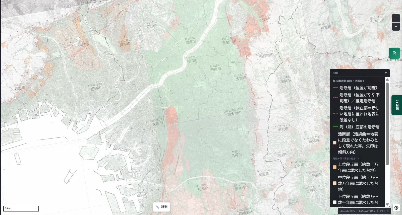
The Uemachi Fault Zone is a reverse fault running roughly 42 km north-south from Toyonaka City through Osaka City to Kishiwada City. The orange upper-terrace terrain spreading across the map is the result of this fault repeatedly uplifting the land on its eastern side with each earthquake, accumulated over a very long span of time. The "Uemachi Plateau" — home to Osaka Castle, Tennoji, and Abeno — is a direct product of this fault activity, and the terrain classification's coloring makes visible just how far that plateau extends, reaching as far as Matsubara and Fujiidera. Because central Osaka is so heavily urbanized, much of the fault itself is shown as a "concealed section," with no visible surface offset.
Try it: the Tachikawa Fault Zone
Here's what it looks like in western Tokyo and the Tama area.
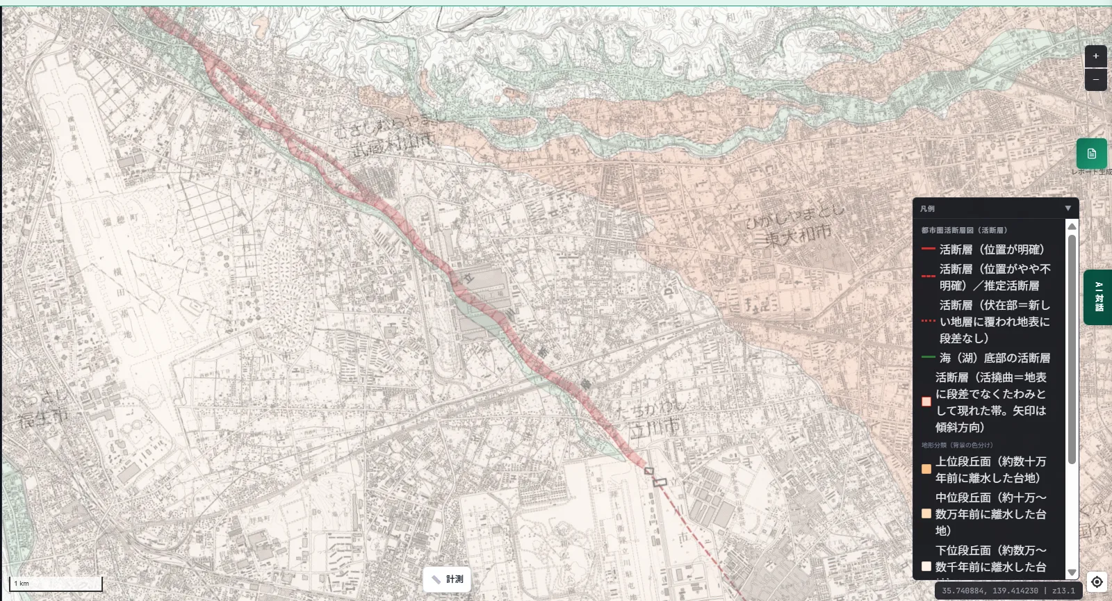
The Tachikawa Fault Zone runs northwest-southeast from Saitama Prefecture through Musashimurayama City and Tachikawa City in Tokyo and into Kanagawa Prefecture. It passes through the urbanized Tama area along the western edge of the Kanto Plain and is considered one of the active faults to watch most closely in the greater Tokyo metropolitan area.
How to read the legend
The legend combines line styles indicating how confidently a fault has been identified with background colors for terrain classification.
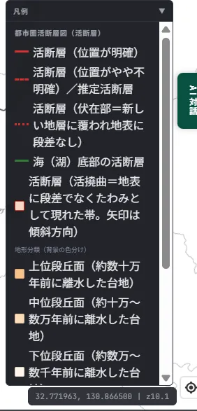
Whether a line is solid, dashed, or dotted tells you how confidently that fault's position has been pinpointed. A "concealed section" (dotted line) means the fault exists but is covered by newer sediment, so no surface offset is currently visible — and the more urbanized an area is, the more likely a fault is to be shown this way.
Being upfront about the real-estate disclosure connection
Unlike the Soil Contamination Countermeasures Act or Natural Parks Act zones we've covered on this blog before, proximity to an active fault, by itself, is not currently a mandatory disclosure item under Article 3, Paragraph 1 of the enforcement order of Japan's Building Lots and Buildings Transaction Business Act. Japan's nationally-mandated list of disclosure items does not include active faults.
That said, it's not uncommon in practice — especially among condominium developers — to voluntarily include active-fault information in a disclosure statement as supplementary information. Some local governments go further: Tokushima Prefecture, for example, has its own ordinance (aimed at building a society resilient to earthquake disasters) that designates "Specified Active Fault Survey Zones" along the Median Tectonic Line active fault system, requiring advance notification and survey for certain facilities of a given scale. This is not a nationwide rule — it's an initiative specific to a handful of local governments, and worth keeping in mind as such.
For MAPRISE users: what matters depending on your role
Precisely because this isn't a legal disclosure requirement, how much attention to pay to it — as optional information — depends on your role.
- Real estate brokers: not a legal requirement, but knowing the position of a property relative to an active fault beforehand can be useful as voluntary information for prospective buyers.
- Developers / funds: check whether an active fault (including concealed sections) runs directly beneath or very close to a development site, as input for grading plans and building placement.
- Banks (lending): use this as one factor in disaster-risk assessment for collateral valuation.
- Legal & appraisal professionals: use this to understand regional factors in an appraisal report, or as part of researching a property's history.
- Local government: use this to cross-check against regional disaster-preparedness plans and damage estimates, and as public-awareness material.
Being upfront about the data source and its limits
This layer is built by processing GSI's "Urban Area Active Fault Maps" (249 sheets nationwide, as of December 2024). It only covers urban areas where this map series has been compiled; it won't display anything in areas not yet covered. Fault locations and how confidently they've been identified reflect the state of knowledge at the time of each survey and may be revised by later research. Please check with GSI or your local government's disaster-preparedness office for the latest information.
Closing
You might have heard the name of an active fault on the news without ever really registering how close it runs to where you actually are. As the Mashiki Town and central Fukuoka examples in this post show, there's real value simply in being able to confirm, on a map, that an active fault runs directly beneath a place where people actually live. We hope this proves useful as one input into site selection and asset management decisions.
Questions or feedback are always welcome at info@maprise.jp.
The active-fault data introduced in this post is reference information created by processing GSI's "Urban Area Active Fault Maps" (249 sheets nationwide, as of December 2024). It covers only the urban areas where this map series has been compiled and will not display anything in areas not yet covered. Fault locations and confidence levels reflect the knowledge available at the time of each survey; please check with GSI or your local government for the latest information. Proximity to an active fault is not currently a mandatory disclosure item under Japan's Building Lots and Buildings Transaction Business Act. For how this relates to disclosure obligations in a specific transaction, please consult a licensed real-estate transaction specialist or other qualified professional.
Tags: #Active faults #Urban Area Active Fault Maps #Disaster preparedness #Kumamoto earthquake #Terrain
Other-language share text (exception cases)
Quick share above follows our platform-locked language policy (X-family in Japanese, LinkedIn in English). The four panes below let you grab the opposite-language body when needed — e.g. introducing an English post to a Japanese audience on X, or posting a Japanese article to LinkedIn in Japanese. Each pane offers both a copy button and a direct intent link.
📝 活断層を地図にしました ― 熊本地震の震源断層から警固断層・上町断層帯・立川断層まで
国土地理院「都市圏活断層図」に基づく活断層レイヤーを実装しました。2016年熊本地震の震源となった布田川断層帯、福岡市中心部を貫く警固断層、大阪の上町台地を形づくった上町断層帯、そして立川断層帯を例に、活断層の見方と重要事項説明との関係を紹介します。
https://maprise.jp/ja/blog/active-fault-lines/ #活断層 #都市圏活断層図
🆕 新しいブログ記事を公開しました。

《活断層を地図にしました ― 熊本地震の震源断層から警固断層・上町断層帯・立川断層まで》

国土地理院「都市圏活断層図」に基づく活断層レイヤーを実装しました。2016年熊本地震の震源となった布田川断層帯、福岡市中心部を貫く警固断層、大阪の上町台地を形づくった上町断層帯、そして立川断層帯を例に、活断層の見方と重要事項説明との関係を紹介します。

👉 詳しくはこちら: https://maprise.jp/ja/blog/active-fault-lines/
📝 Active Faults, Mapped — From the 2016 Kumamoto Earthquake's Source Fault to the Kego, Uemachi, and Tachikawa Faults
We've implemented an active-fault layer based on Japan's Geospatial Information Authority (GS…
https://maprise.jp/en/blog/active-fault-lines/ #Activefaults #UrbanAreaActiveFaultMaps
🆕 New on the MAPRISE blog.

《Active Faults, Mapped — From the 2016 Kumamoto Earthquake's Source Fault to the Kego, Uemachi, and Tachikawa Faults》

We've implemented an active-fault layer based on Japan's Geospatial Information Authority (GSI) 'Urban Area Active Fault Maps.' Using the Futagawa Fault Zone (source of the 2016 Kumamoto earthquake), the Kego Fault running through central Fukuoka, the Uemachi Fault Zone that shaped Osaka's Uemachi Plateau, and the Tachikawa Fault Zone as examples, here's how to read the layer and how it relates to real-estate disclosure.

👉 Read the full post: https://maprise.jp/en/blog/active-fault-lines/

#Activefaults #UrbanAreaActiveFaultMaps #Disasterpreparedness #Kumamotoearthquake #Terrain