A sequel to our article on the Zushi slope collapse. Maintaining a retaining wall is the responsibility of the person who holds the land, not the government or a management company. We sort out what is covered in the pre-contract property disclosure and what the statutes do not mention, then compare land prices, elevation and sediment disaster warning areas (yellow zones) in residential areas of Sapporo, Kobe, Minoh and Setagaya.
Hello, this is the MAPRISE team.
In Part 1, starting from the slope collapse in Zushi, Kanagawa, we sorted out what responsibility the holder of cliff-top property has for the slope and retaining wall beneath it, and looked for places in 15 Japanese cities where yellow zones overlap the edge of an abrupt change in elevation.
This sequel goes one step further and asks: what should you check before you buy? A home with a good view on high ground is attractive. But choosing on "nice view" and "high ground, so safe from floods" alone can make you overlook the retaining wall under your feet, a risk that is hard to see.
Key points
- Maintaining a retaining wall is not something the government or a management company does for you. It is the responsibility of the person who holds the land or building (owner, manager, occupant).
- In the pre-contract property disclosure by a real estate agent, whether the property is in a sediment disaster warning area is explained, but the condition and repair history of the retaining wall do not appear in the statutes as items to be explained. You have to check them yourself.
- "High ground", "a view" and "a high land price" are not a measure of safety. Yellow zones exist in the most expensive residential areas and in inexpensive ones.
- With MAPRISE you can place the colored contour map, land prices and warning areas side by side at the same position, and check whether a site is above or below a cliff and whether it falls in a zone, before you buy.
Repairing a retaining wall is the holder's responsibility
Civil Code: the owner can be liable even without fault
Article 717 of the Civil Code says that when a defect in the installation or maintenance of a structure on land (including a retaining wall) causes damage to another person, the occupant of the structure is liable first; if the occupant took the care necessary to prevent the damage, the owner must pay compensation. The owner's liability has the character of strict liability, regardless of fault.
If you live in your own house, owner and occupant are the same person. Even if you rent the property out, as long as the tenant took the necessary care, the owner who rents it out is liable.
Act on Regulation of Residential Land and Specified Fill: maintenance is a duty of effort for the person holding the land
The Act on Regulation of Residential Land and Specified Fill (in force since 2023) contains provisions on maintaining retaining walls.
| Article | Content (summary) |
|---|---|
| Art. 22 | Owners, managers and occupants of land inside a regulated residential land development area must endeavor to keep the land in a constantly safe condition so that no disaster occurs. The prefectural governor may recommend measures such as installing or modifying retaining walls |
| Art. 23 | When a retaining wall that is necessary has not been installed or is extremely inadequate, and leaving it would create a serious risk of disaster, the governor may order the owner and others to carry out work to install or modify it (improvement order) |
| Art. 46 | Owners, managers and occupants of developed residential land in a developed-land disaster prevention area must endeavor to take necessary measures such as installing or modifying retaining walls |
In other words, the role of the government is to designate areas and, when necessary, to issue recommendations and orders. The cost and effort of repairing the wall fall on the person who holds the land; this is the basic idea of the law. Article 22 concerns land inside a regulated area; outside it, the Civil Code liability applies in the same way.
The pre-contract disclosure: what is explained, and what the statutes do not mention
When you buy from a real estate company, a licensed real estate transaction specialist explains important matters before the contract. We checked the original statutory text (the Real Estate Transaction Business Act, its Enforcement Order and its Enforcement Regulations) to see what is explained and what does not appear.
| What you want to know | Treatment in the law | Basis |
|---|---|---|
| Is the property in a developed-land disaster prevention area? | Item to be explained (sale or exchange of land and buildings) | Enforcement Regulations Art. 16-4-3, item 1 |
| Is the property in a sediment disaster warning area? | Item to be explained (same) | Enforcement Regulations Art. 16-4-3, item 2 |
| Restrictions in special warning areas, steep-slope collapse hazard areas, regulated areas under the fill act, etc. | Outline of restrictions under law is explained | Act Art. 35(1)(ii), Enforcement Order Art. 3 |
| Retaining wall deterioration, repair history, certificate of inspection | The word "retaining wall" does not appear (searching the full text of the Act, the Order and the Regulations returned 0 hits) | – |
| View, or future blocking of the view | The word "view" does not appear (same, 0 hits) | – |
Whether the property lies in a warning area is always explained, but the condition of the retaining wall itself is not listed as a statutory item. Hearing "no problems" in the disclosure therefore does not tell you whether the wall is safe.
What to check yourself
When considering land or a house with a retaining wall, it is wise to confirm the following with the seller, the agent and the local government, separately from the disclosure.
- Height and structure of the wall: building a retaining wall over 2 m high requires a structure confirmation application under the Building Standards Act (Shinjuku Ward guide, Japanese). Check whether it is reinforced concrete, block or stone masonry.
- Certificate of confirmation and certificate of inspection: a retaining wall over 2 m without a certificate of inspection may be treated as a "cliff" under local cliff ordinances (Funabashi City guide, Japanese). Handling differs by municipality, so ask the building guidance office.
- Whose wall is it? Is a wall on the boundary yours or your neighbor's? This affects who pays for repairs and how consent is obtained.
- Cracks, bulging, clogged weep holes, drainage: look at the wall and its foot on site. Having an expert (architect or a company that can assess retaining walls) look at it is also an option.
- Records of past repairs and inspections: ask the seller for drawings and work history.
- Is your site above or below the cliff? If above, you are the side responsible for maintaining the wall. If below, you are the side that may be hit if soil or a wall collapses from the land above.
Don't judge by view and high ground alone
"A good view" and "a safe site" are different things. Places with a good view are higher than their surroundings, which often means near a cliff or steep slope.
| An easily overlooked assumption | Reality |
|---|---|
| High ground, so safe from floods | Good against floods in some ways, but sediment disasters occur on sloping ground |
| An expensive upscale area must be safe | Zones are designated by terrain conditions such as slope and height, not by land price |
| The disclosure said no problems | Retaining wall condition is not among the items explained |
| There is a retaining wall, so it's fine | Walls can stop working because of aging or poor drainage |
Land price, high ground, residential areas and yellow zones, city by city
Below are examples of residential areas, where we placed the colored contour map (left) and sediment disaster warning areas (right) side by side in MAPRISE's 2-split view and also overlaid land prices (published land prices and prefectural land price surveys, 2024).
How to read this: land prices are the values of survey points within the view, not prices of land inside a warning area. We counted only points used as residential land (points combined with shops or offices are excluded). The price dates of the published land prices and the prefectural survey differ. Elevations are approximate values from the GSI elevation API.
Sapporo: a residential area at the foot of a mountain (Miyanomori, Chuo Ward)
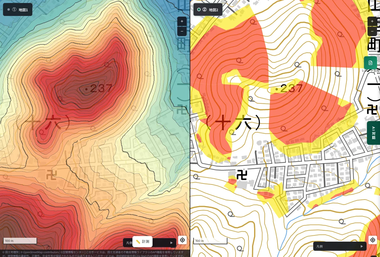
The elevation point of the mountain in the view is 237 m. The residential area just below is around 150 m, and the lower ground to the northeast is about 60 m. On the right, a large red special warning area (red zone) spreads over the slope, with a yellow warning area around its edge. A street lined with houses lies just below the red area.
The land price of the residential point in the view was 112,000 yen/㎡ (Miyanomori 1-jo 14-chome, published land price). It shows that the level of the land price and the severity of the zone are unrelated.
Kobe: the mountain side of the Sumiyoshi River (Higashinada Ward, Nishiokamoto to Sumiyoshi-honmachi)
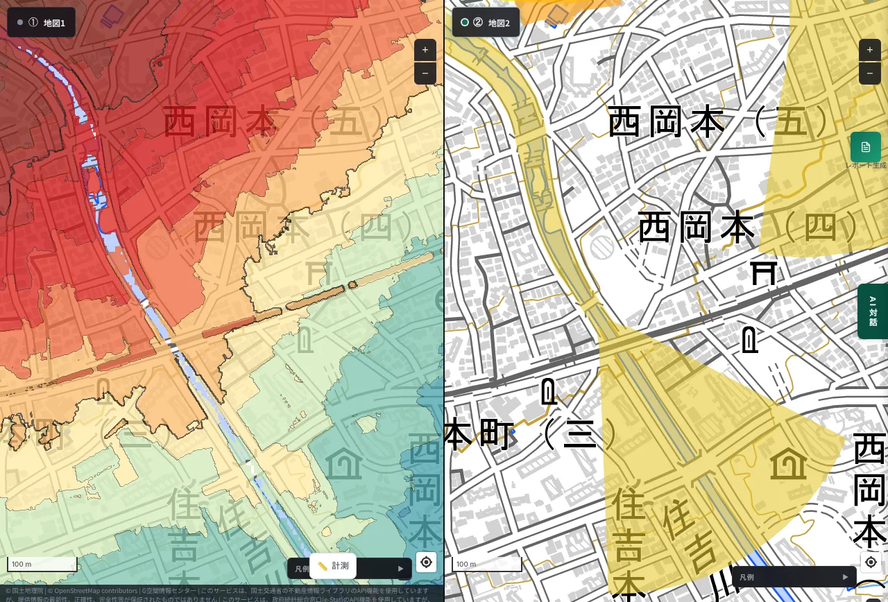
The elevation drops from the mountains toward the city along the Sumiyoshi River. The southeast of the view is in the 20 m range, and about 1.4 km to the north, the elevation is 90 to 140 m. On the right, large yellow fan shapes (debris-flow warning areas) spread on both sides of the river.
Residential land prices in the view range from 161,000 yen/㎡ (Nishiokamoto 7-chome) to 625,000 yen/㎡ (Okamoto 9-chome), about a fourfold difference within one screen (Sumiyoshi-yamate 2-chome 450,000, Nishiokamoto 5-chome 454,000, Mikage-gunke 1-chome 495,000 yen/㎡, and others). The point on the mountain side (Nishiokamoto 7-chome) is the lowest, and prices and the way risk appears differ between a house with a view on the mountain side and a house in the city.
Minoh: the residential foot of the mountain north of Minoh Station (Minoh City)
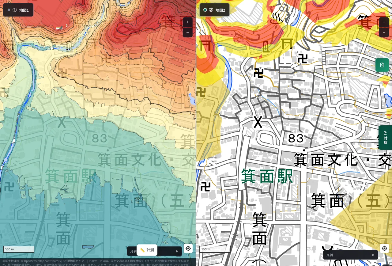
The elevation near Minoh Station is about 80 m, and about 800 m to the north it reaches 240 m. On the right, a yellow band runs along the valley north of the station, and a large fan shape (debris-flow warning area) is also visible east of the station.
Residential land prices in the view range from 158,000 yen/㎡ (Minoh 2-chome) to 284,000 yen/㎡ (Minoh 6-chome). It shows that there are places very close to the station where zones apply.
Setagaya: the valley of Todoroki Gorge (Todoroki to Noge, Setagaya Ward)
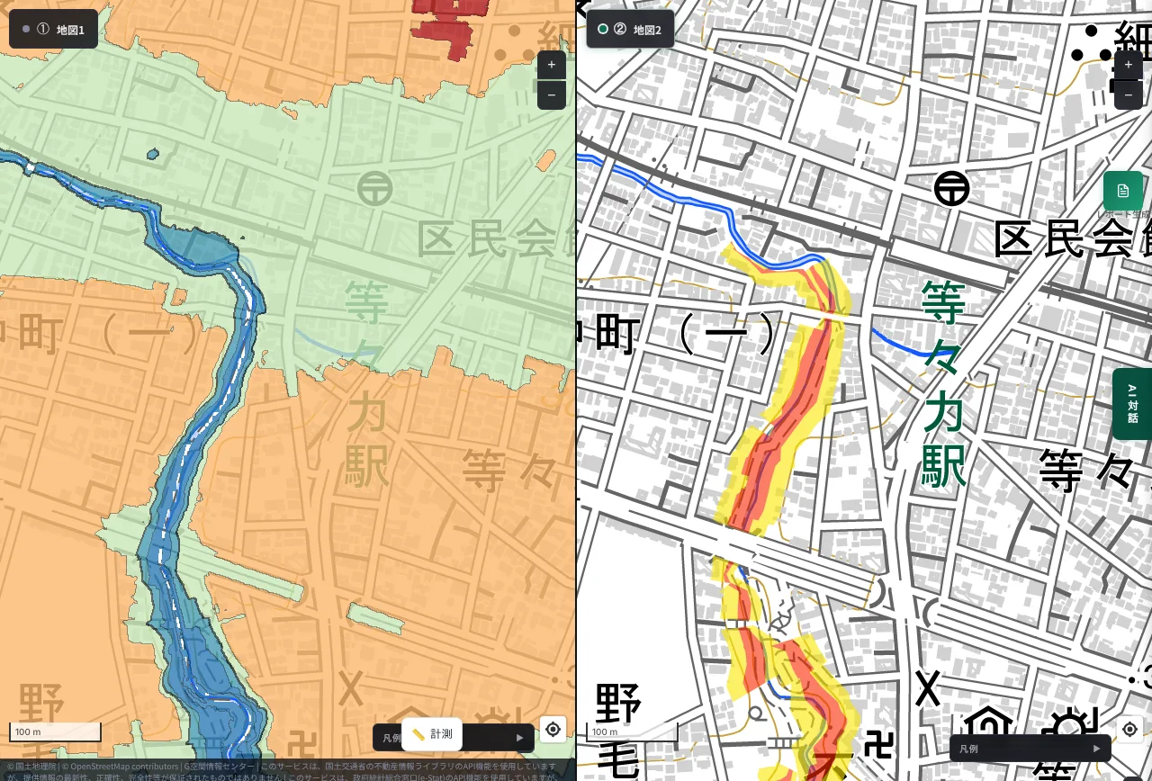
Even within Tokyo's 23 wards there are places with relief. Todoroki Gorge is a valley cut into a plateau (about 30 m), with the valley floor in the low 20 m range. The drop is under 10 m, but on the right red and yellow bands run along the valley.
Residential land prices in the view range from 613,000 yen/㎡ (Noge 1-chome) to 857,000 yen/㎡ (Kaminoge 1-chome). Even when the height difference is small, zones can be designated along valleys and the edges of escarpments. It is a place that is easy to miss if you only think of "flat residential areas in the 23 wards".
Land prices at the places in Part 1 and this article
We also checked land prices at the places in Part 1 on the same basis (residential points, 2024), and lined them up with this time's places.
| Place | Residential land prices in the view (yen/㎡) | How zones appear |
|---|---|---|
| Azabu, Minato Ward, Tokyo | 2,450,000–2,970,000 | A yellow band runs along the edge of the plateau |
| Yamate, Naka Ward, Yokohama | 294,000–820,000 | Yellow and red zones are scattered along the plateau edge |
| Around Nagaoka, Fukuoka | 138,000–186,000 | Yellow and red bands run along the edge of a hill |
| Miyanomori, Sapporo (this article) | 112,000 (one point) | A red special warning area spreads over the slope |
| Higashinada Ward, Kobe (this article) | 161,000–625,000 | Large yellow fans on both sides of a river |
| Minoh (this article) | 158,000–284,000 | A yellow band along the valley and a fan to the east |
| Todoroki, Setagaya (this article) | 613,000–857,000 | Narrow red and yellow bands along the valley |
Land prices span more than a twentyfold range, from about 112,000 to about 2.97 million yen/㎡. Even so, every place has warning areas. A high land price does not by itself indicate safety underfoot.
Check this much on the map before you buy
In MAPRISE you can check a site of interest in the following order.
- Show the colored contour map and see whether the site is above or below a cliff or steep slope.
- Switch to 2-split view, show sediment disaster warning areas on the other screen, and check the relationship between the site and the zones at the same position and scale.
- Overlay land prices and compare the surrounding published land prices and survey values with whether the place is near a zone.
- If the site is near a zone or the height difference is large, before the property disclosure, confirm the condition of the retaining wall, the certificates of confirmation and inspection, and the official data on zones with the seller, the agent and the local government.
2-split view is available even on the free Free plan (4-split view requires Starter or above). For land prices, the Free plan shows the latest 3 years (Starter and Pro 10 years, Business all years). Conditions by plan are on the pricing page. The data you can display is listed in the layer list, and the data sources are in Data sources.
With MAPRISE, you can check the "cliff risk" of a site yourself, before you buy. Open MAPRISE
Limits of this article
- Warning areas are approximate extents at the time of survey, and being outside a zone does not mean being safe. The screen shows tiles of the Hazard Map Portal Site, and boundary positions may not be exact.
- Land prices are the values of survey points within the view. They do not indicate the price of individual land inside a warning area or a sale price. The published land prices and the prefectural land price survey have different price dates.
- Elevations are approximate values obtained from GSI elevation data and may be off by several meters.
- The legal summary is based on the statutory text as of October 2026 and does not give a judgment for an individual transaction. For decisions on retaining walls and contracts, consult a licensed real estate transaction specialist, an architect or a lawyer, and the local government's counter.
- The places taken up do not point to a specific property or owner. We chose each place for its abrupt change in colors; they do not represent the trend of an entire city.
- Images were taken with the legend collapsed for readability.
For related topics, see Part 1: cliff-top property and retaining wall management, Fill-land regulation areas and large-scale fill, Solar panels on slopes and landslide warning areas and Elevation of Yamanote and Shitamachi. Questions and comments are welcome at info@maprise.jp.
Sources
- Act on Regulation of Residential Land and Specified Fill (e-Gov, Japanese): Arts. 22, 23, 46
- Real Estate Transaction Business Act (e-Gov, Japanese): Art. 35
- Enforcement Order of the Real Estate Transaction Business Act (e-Gov, Japanese): Art. 3
- Enforcement Regulations of the Real Estate Transaction Business Act (e-Gov, Japanese): Art. 16-4-3
- Civil Code (e-Gov, Japanese): Art. 717
- Shinjuku Ward: guide to structure confirmation for retaining walls; Funabashi City: guide to cliff ordinances and certificates of inspection (links above)
- Ministry of Land, Infrastructure, Transport and Tourism: published land prices and prefectural land price survey (2024)
- MLIT / GSI Hazard Map Portal Site (sediment disaster warning areas)
- GSI elevation API and colored elevation map
The images in this article are MAPRISE 2-split view screens (left: colored contour map, right: sediment disaster warning areas from the Hazard Map Portal Site). Elevations are from the Geospatial Information Authority of Japan, land prices from MLIT, and warning areas from MLIT and GSI data, processed by Vulcanz LLC as reference information. They do not guarantee the safety or value of any individual site. Parts of the map are provided by OpenStreetMap contributors and the Geospatial Information Authority of Japan.
Tags: #retaining wall #sediment disaster warning area #yellow zone #property disclosure #land price #hill #view #Act on Regulation of Residential Land and Specified Fill #structure liability #Sapporo #Kobe #Minoh #Setagaya #colored contour map #split view
Other-language share text (exception cases)
Quick share above follows our platform-locked language policy (X-family in Japanese, LinkedIn in English). The four panes below let you grab the opposite-language body when needed — e.g. introducing an English post to a Japanese audience on X, or posting a Japanese article to LinkedIn in Japanese. Each pane offers both a copy button and a direct intent link.
📝 崖の上の家は、眺望と高台だけで選んではいけない ― 擁壁の責任、重要事項説明、地価とイエローゾーンを都市別に確かめる【続編】
逗子の斜面崩落事故の続編です。擁壁の修繕・管理は、行政や管理会社ではなく、土地を持つ人の責任です。買うときの重要事項説明で説明される項目と、法令の条文に出てこない項目を整理し、札幌・神戸・箕面・世田谷など都市の住宅地について、地価・標高・土砂災害警戒区域(イエローゾーン)を並べて確かめました。
https://maprise.jp/ja/blog/cliff-land-price-view-retaining-wall/ #擁壁 #土砂災害警戒区域
🆕 新しいブログ記事を公開しました。

《崖の上の家は、眺望と高台だけで選んではいけない ― 擁壁の責任、重要事項説明、地価とイエローゾーンを都市別に確かめる【続編】》

逗子の斜面崩落事故の続編です。擁壁の修繕・管理は、行政や管理会社ではなく、土地を持つ人の責任です。買うときの重要事項説明で説明される項目と、法令の条文に出てこない項目を整理し、札幌・神戸・箕面・世田谷など都市の住宅地について、地価・標高・土砂災害警戒区域(イエローゾーン)を並べて確かめました。

👉 詳しくはこちら: https://maprise.jp/ja/blog/cliff-land-price-view-retaining-wall/
📝 Don't Choose a Cliff-Top Home on View and Elevation Alone: Retaining Walls, Disclosure Rules, Land Prices and Yellow Zones, City by City (Part 2)
A sequel to our article on the Zushi slope collapse. Mainta…
https://maprise.jp/en/blog/cliff-land-price-view-retaining-wall/ #retainingwall #sedimentdisasterwarningarea
🆕 New on the MAPRISE blog.

《Don't Choose a Cliff-Top Home on View and Elevation Alone: Retaining Walls, Disclosure Rules, Land Prices and Yellow Zones, City by City (Part 2)》

A sequel to our article on the Zushi slope collapse. Maintaining a retaining wall is the responsibility of the person who holds the land, not the government or a management company. We sort out what is covered in the pre-contract property disclosure and what the statutes do not mention, then compare land prices, elevation and sediment disaster warning areas (yellow zones) in residential areas of Sapporo, Kobe, Minoh and Setagaya.

👉 Read the full post: https://maprise.jp/en/blog/cliff-land-price-view-retaining-wall/

#retainingwall #sedimentdisasterwarningarea #yellowzone #propertydisclosure #landprice
Related posts
- Who Looks After the Slope and Retaining Wall Beneath a Cliff-Top Property? ― The Zushi Accident, and Yellow Zones Across Japan on a Split-Screen Elevation Map2026-10-24
- Musashi-Kosugi, Then and Now, and Where Its Hazards Stand Today ― Re-reading the Location Through Elevation, Landform and History2026-10-21
- Did the Rich Move Uphill to Avoid Floods? Testing 'Yamanote vs Shitamachi' in Tokyo, Nagoya, Osaka and Fukuoka with Four Maps2026-10-24