Last time we looked at Haneda, Narita, Kansai, Itami and Fukuoka on the Aircraft Overflight Frequency (Reference) layer. This time we display the two airports built on reclaimed islands, Kansai International and Chubu Centrair, and talk about the routes that run out over the sea, the night share, and the limits of the map.
Hello from the MAPRISE team.
In the previous post we looked at Haneda, Narita, Kansai, Itami and Fukuoka on the new "Aircraft Overflight Frequency (Reference)" layer. This time we take a closer look at the two airports built on islands reclaimed from the sea that we could not cover properly there: Kansai International Airport and Chubu Centrair International Airport.
Two airports built on the sea
Kansai International Airport opened on September 4, 1994 on an artificial island in Osaka Bay. Runway B (4,000 m) on the second island joined Runway A (3,500 m) in August 2007, and the national government describes it as Japan's first international hub airport capable of full 24-hour operation.
Centrair opened in 2005 on an artificial island off Tokoname, Aichi. It has one 3,500 m runway, and the runway is reported to need closing for maintenance at night. The Ministry of Land, Infrastructure, Transport and Tourism has announced that a second, 3,290 m runway is scheduled to open on March 31, 2028.
Kansai: a red band running from the island over the sea
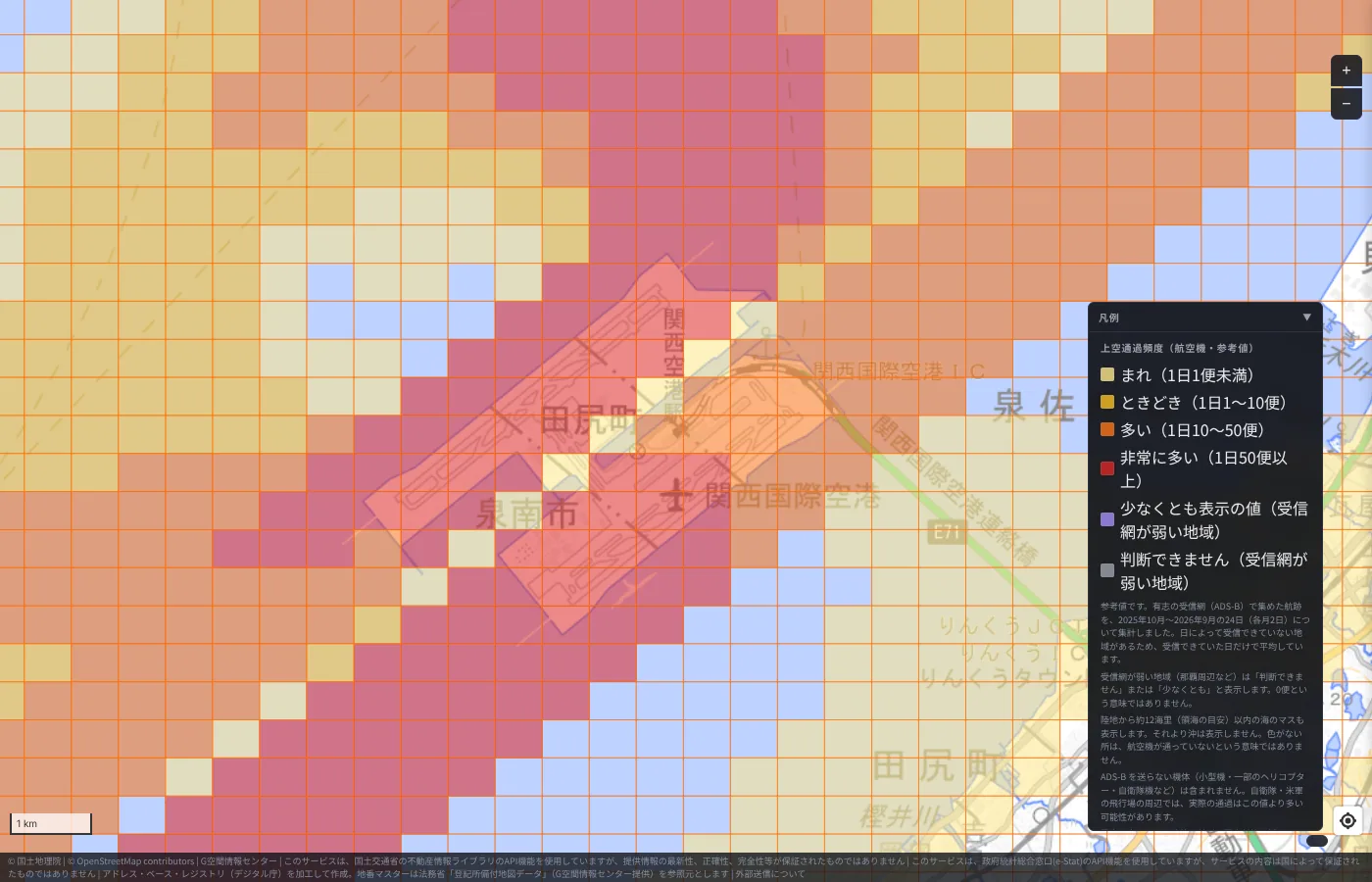
The island is packed with red cells. At the busiest cell, 183 flights per day passed within 1 km, and the average over the cells on the island was around 100 flights per day. You can also see the cells lining up along the two runways.
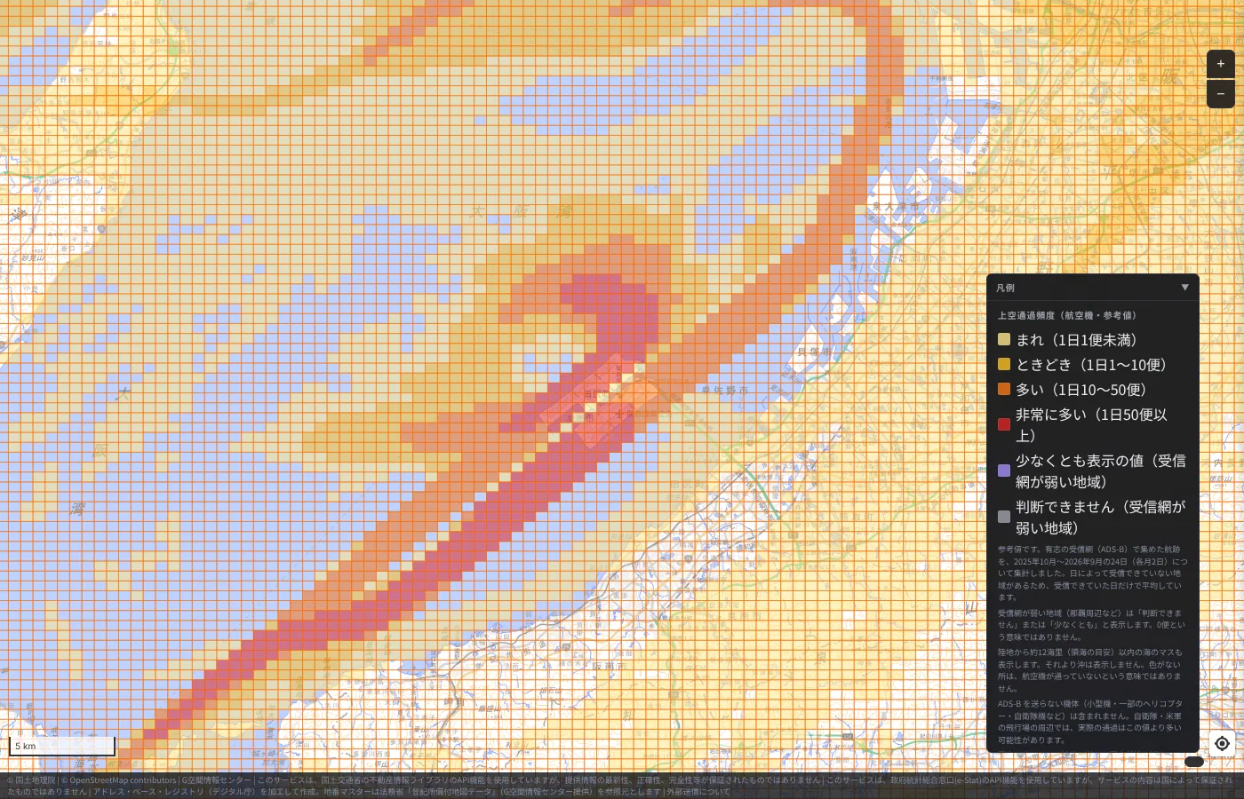
Zooming out, a long red band runs from the island to the southwest over the sea, and an orange band arcs along Osaka Bay to the northeast. On land, pale yellow cells spread everywhere. It makes clear that the approach paths to the island lie over the sea.
Centrair: along a single runway
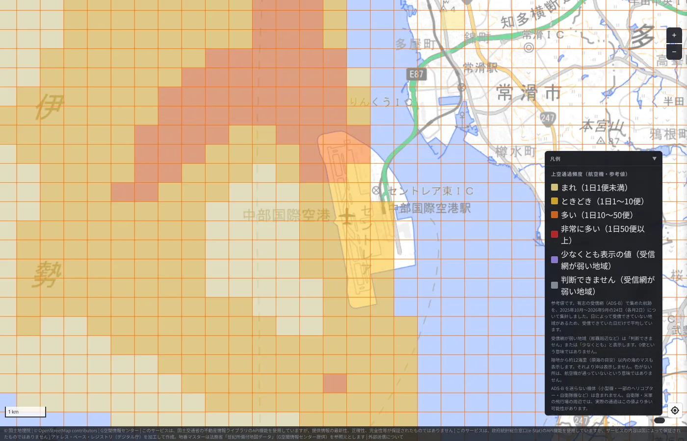
At Centrair, the darkest colors are on the island and on a band running north from it over the sea. Among the cells on the island, even the busiest has about 21 flights per day, in the "Frequent (10–50 flights/day)" band. Compared with Kansai's "Very frequent", the difference in scale shows up directly in the color. The shape of a long, narrow island with one runway can also be read from the cells.
The night share is not as different as we expected
Because both airports can operate at night, we expected many night flights and looked at the "night share (22:00–7:00)" for each cell. On the islands it was about 10% at Kansai and about 8% at Centrair.
At the points we clicked in the previous post, Haneda was 9% and Narita 6%, while Itami and Fukuoka, which have operating-hour limits, were 0%. So a 24-hour airport does not necessarily have a much larger night share. This share covers 22:00 to 7:00 together, including flights at 22:00–23:00 and 6:00–7:00; it does not separate out only the late-night flights.
How far over the sea are cells shown?
In the first version of this article we wrote that we did not know why the sea outside the islands has no color. We have since looked into it: the cause was not a lack of data, but that we had not put cells over the sea on the map.
We have therefore updated the layer to also show sea cells within about 12 nautical miles of land (a rough guide to territorial waters). Areas farther offshore are not shown. Actual territorial waters are measured from the "baseline", but here we substitute the straight-line distance from land cells, so this is only a rough guide. It does not match sea areas where the territorial sea is narrower, such as some straits, or areas bordering neighboring countries.
Checking against the aggregation results, within 5-10 km of Kansai over the sea there are cells where up to about 165 flights per day pass within 1 km, and 54 cells in the "Very frequent (50+ flights/day)" band. Over the sea at Centrair, in the same range, there are cells with about 29 flights per day. Off Haneda it is even higher, up to about 318 flights per day.
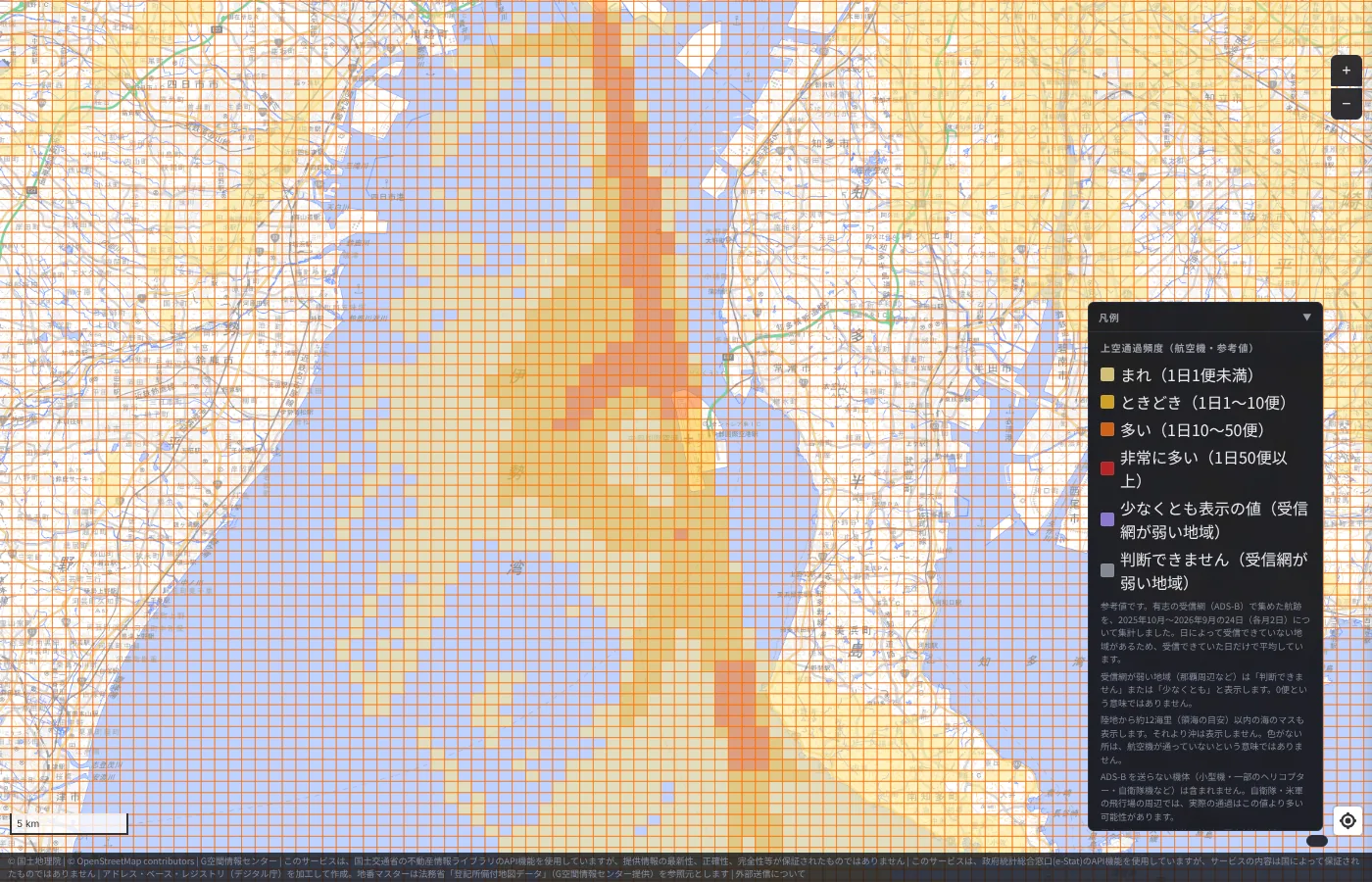
Note that over the sea some cells have weak receiver coverage and are shown without color or in the "at least" purple. A cell with no color does not mean that no aircraft pass there. Around Centrair in particular many purple cells appear over the sea, so actual flight counts may be higher than the values shown.
How to view it in MAPRISE
In the "Living facilities / School districts" group, choose "Aircraft Overflight Frequency (Reference)". It can be displayed without logging in. Zoom in and check how the shape of each island relates to the color.
These are reference values only, so please also check the materials published by each airport and municipality before making important decisions. Questions and comments are welcome at info@maprise.jp.
Sources and references
- Aircraft overflight frequency: created from flight tracks by adsb.lol contributors (ODbL 1.0), Copernicus DEM and EGM2008
- Kansai International Airport opening, Runway B and full 24-hour operation: MLIT document
- Centrair runway and the planned replacement runway: MLIT
- Maps and data: the provider and license of each dataset are listed in Data Sources, and the data available on the map in the Layer Catalog
Tags: #Aircraft overflight #Aircraft #Airports #Kansai International #Chubu Centrair #Centrair #Offshore airports #New layer
Other-language share text (exception cases)
Quick share above follows our platform-locked language policy (X-family in Japanese, LinkedIn in English). The four panes below let you grab the opposite-language body when needed — e.g. introducing an English post to a Japanese audience on X, or posting a Japanese article to LinkedIn in Japanese. Each pane offers both a copy button and a direct intent link.
📝 海の上の空港は、地図でどう見えるか ― 関西空港とセントレアを「上空通過頻度」で見る
前回は羽田・成田・関西・伊丹・福岡を取り上げた「上空通過頻度(航空機・参考値)」レイヤー。今回は、海を埋め立てた島にある関西国際空港と中部国際空港(セントレア)を表示します。島から海の上へ伸びる飛行機の通り道、夜間の割合、そして地図の限界についてお話しします。
https://maprise.jp/ja/blog/centrair-kansai-airports/ #上空通過頻度 #航空機
🆕 新しいブログ記事を公開しました。

《海の上の空港は、地図でどう見えるか ― 関西空港とセントレアを「上空通過頻度」で見る》

前回は羽田・成田・関西・伊丹・福岡を取り上げた「上空通過頻度(航空機・参考値)」レイヤー。今回は、海を埋め立てた島にある関西国際空港と中部国際空港(セントレア)を表示します。島から海の上へ伸びる飛行機の通り道、夜間の割合、そして地図の限界についてお話しします。

👉 詳しくはこちら: https://maprise.jp/ja/blog/centrair-kansai-airports/
📝 How Do Airports on the Sea Look on a Map? Kansai and Centrair on the Aircraft Overflight Layer
Last time we looked at Haneda, Narita, Kansai, Itami and Fukuoka on the Aircraft Overflight Frequency (Reference) layer. Thi…
https://maprise.jp/en/blog/centrair-kansai-airports/ #Aircraftoverflight #Aircraft
🆕 New on the MAPRISE blog.

《How Do Airports on the Sea Look on a Map? Kansai and Centrair on the Aircraft Overflight Layer》

Last time we looked at Haneda, Narita, Kansai, Itami and Fukuoka on the Aircraft Overflight Frequency (Reference) layer. This time we display the two airports built on reclaimed islands, Kansai International and Chubu Centrair, and talk about the routes that run out over the sea, the night share, and the limits of the map.

👉 Read the full post: https://maprise.jp/en/blog/centrair-kansai-airports/

#Aircraftoverflight #Aircraft #Airports #KansaiInternational #ChubuCentrair
Related posts
- Where Do Airplanes Actually Fly? Haneda, Narita, Kansai, Itami and Fukuoka on the Aircraft Overflight Layer2026-10-21
- Nagasaki Station at 1 m: What a Hillside City Really Looks Like ― Colored Contour Maps Built from Nagasaki Prefecture's Point Cloud2026-10-21
- Tsunami Disaster Warning Areas, Now Nationwide — Updating Our Preparedness While the Nankai Trough Stays Quiet2026-10-12