Our tsunami disaster warning area data used to cover only six Kyushu prefectures. We surveyed all 47 prefectures and now include 495 municipalities in 31 prefectures. Here is an overview of conditions along the Pacific coast, and why checking the latest hazard information matters.
Hello from the MAPRISE team.
Our "tsunami disaster warning area" data originally covered only six Kyushu prefectures. We have now extended it nationwide: we surveyed all 47 prefectures and cover 495 municipalities in the 31 prefectures that have designations (as of October 2026). In this post we explain what the data is and isn't, and then give an overview of conditions along the Pacific coast.
Being upfront about the data
- Coverage: All 47 prefectures were surveyed; 495 municipalities in 31 prefectures with designations are included.
- Unit: Whether a municipality has a designation or not. The layer covers Tsunami Disaster Warning Areas (yellow zones) and Special Warning Areas (orange zones).
- Source: Materials published by each prefecture (designations under the Act on Special Measures Concerning Tsunami Disaster Prevention Community Development).
- As of: October 2026. Prefectures add designations over time, so please check with the prefecture for the latest status.
One point is very important. Prefectures do not publish vector boundary data for these zones (only PDF maps), so this layer is not the exact zone boundary; it indicates that "somewhere in this municipality there is a designated area." Municipal boundaries are drawn with dashed lines at low opacity. The actual zones cover only part of each municipality; please use the link in the popup (each prefecture's PDF map) to check the exact boundary.
This designation is also a separate system from the tsunami inundation estimate (the flood depth shown on hazard maps), with a different legal basis and designating authority. We recommend viewing both together.
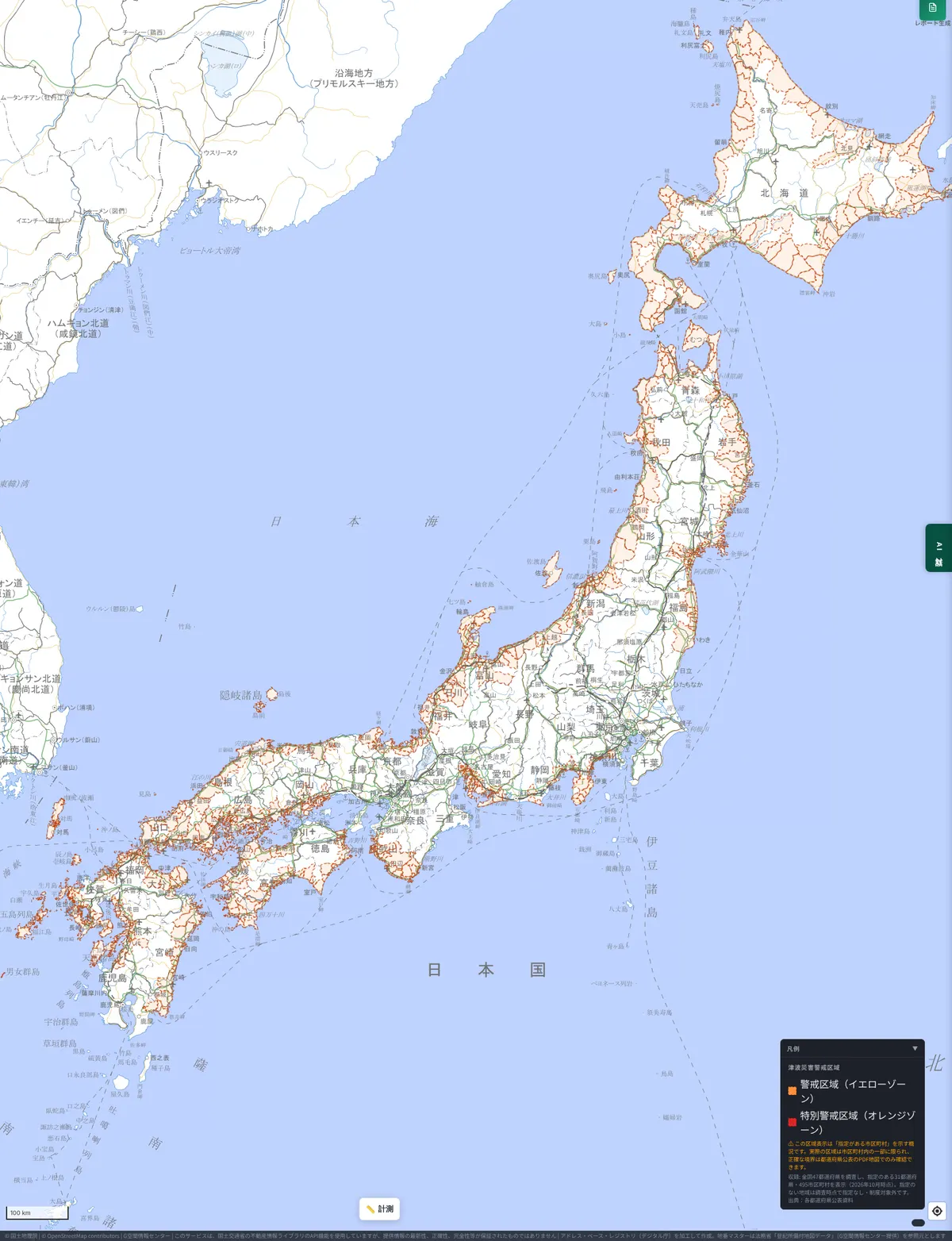
A tour of the Pacific coast
The following is a general overview of tsunami risk by region. Designations and their extent differ by municipality, so please check the map for your area.
Tohoku to Kanto (Sanriku, Fukushima, Ibaraki, Boso)
These areas suffered major tsunami damage in the 2011 Great East Japan Earthquake. The Sanriku coast is known for waves growing taller at the heads of its ria inlets. Relocation to higher ground and seawall construction advanced during reconstruction, and estimates and designations have continued to be reviewed by the prefectures. The Pacific coasts of Ibaraki and Chiba (Boso) are also areas where preparation is under way.
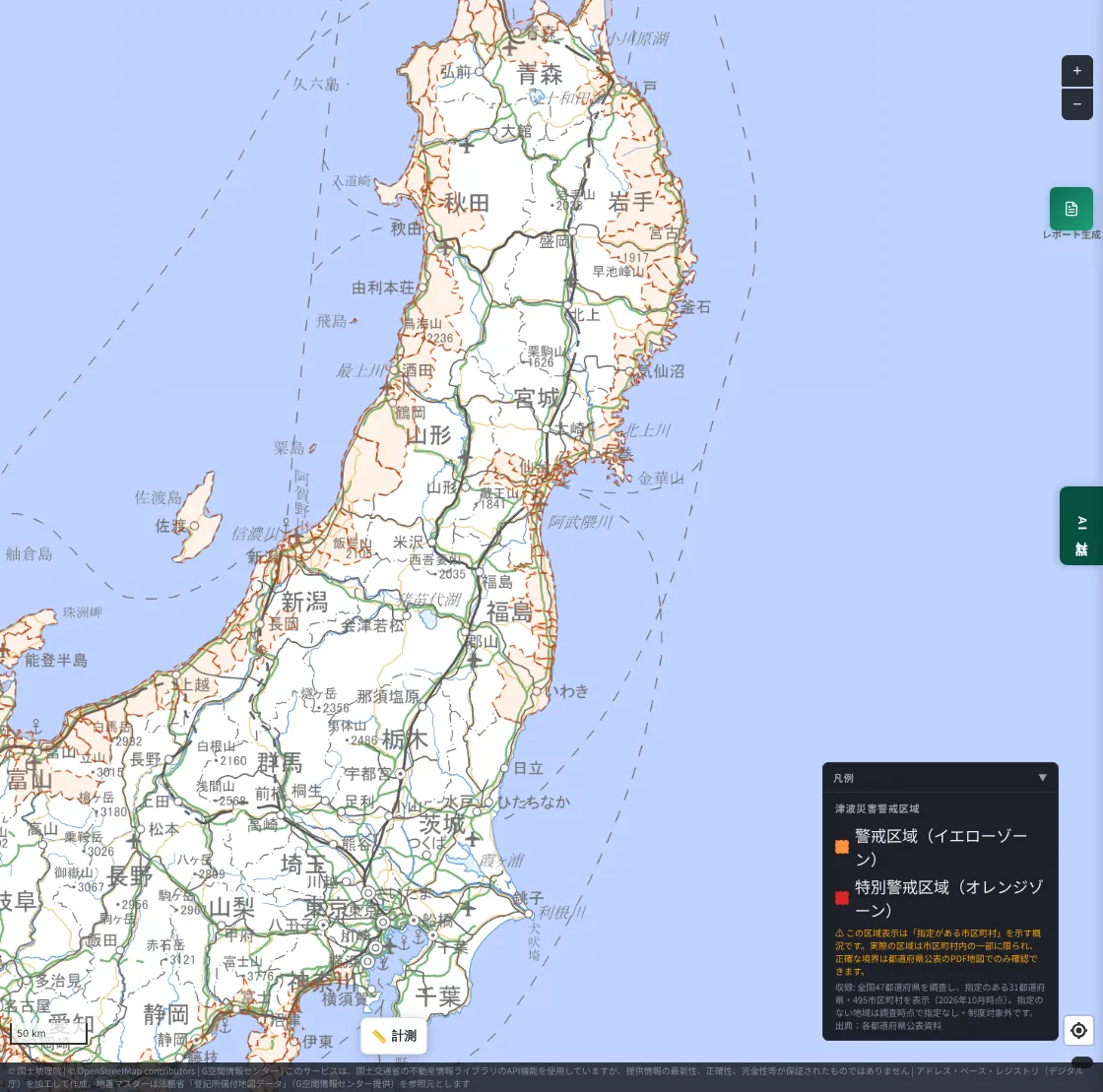
Tokyo area, Sagami Bay and Izu
For the densely populated shores of the Tokyo metropolitan area, the number of people who need to evacuate is a challenge in addition to wave height. Along Sagami Bay, such as Kamakura and Fujisawa, the coast and the urban area are close together, and in some places the distance to higher ground is not short.
The areas tinted on this map are the municipalities of Kanagawa along Sagami Bay and the Izu Peninsula. There is no tint along Tokyo Bay or the Boso Peninsula because, at the time of our survey (October 2026), no Tsunami Disaster Warning Area designation could be confirmed in Tokyo or Chiba. The absence of a tint does not mean there is no tsunami risk.
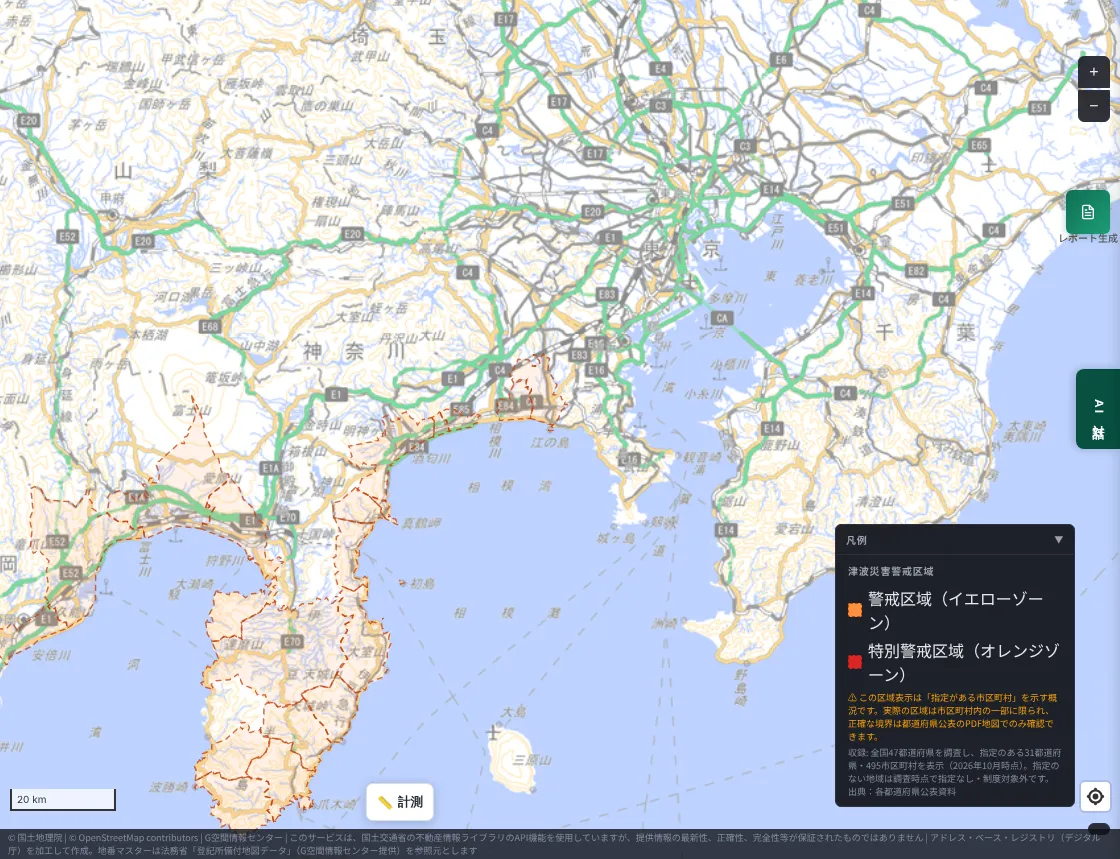
Tokai to Tonankai (Shizuoka, Aichi, Mie)
These areas are close to the Nankai Trough source region, and tsunami arrival times are expected to be short. Preparation is called for over a wide area, including around Lake Hamana, the Enshu-nada coast, and the shores of Ise Bay.
The areas tinted on this map are the Ise Bay coast of Aichi and the Shizuoka coast from Lake Hamana to Enshu-nada. There is no tint along the Mie coast, including the Shima Peninsula, because, at the time of our survey (October 2026), no Tsunami Disaster Warning Area designation could be confirmed there. According to news reports, Mie Prefecture plans to designate coastal municipalities during fiscal 2026 (Chunichi Shimbun, Tsu City). Whether or not a designation exists, the Mie coast is also an area that needs to prepare for a Nankai Trough tsunami.
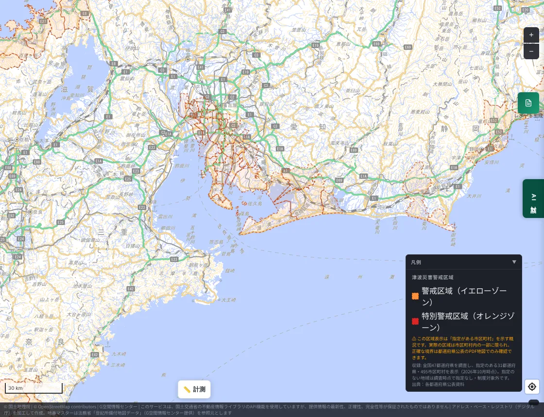
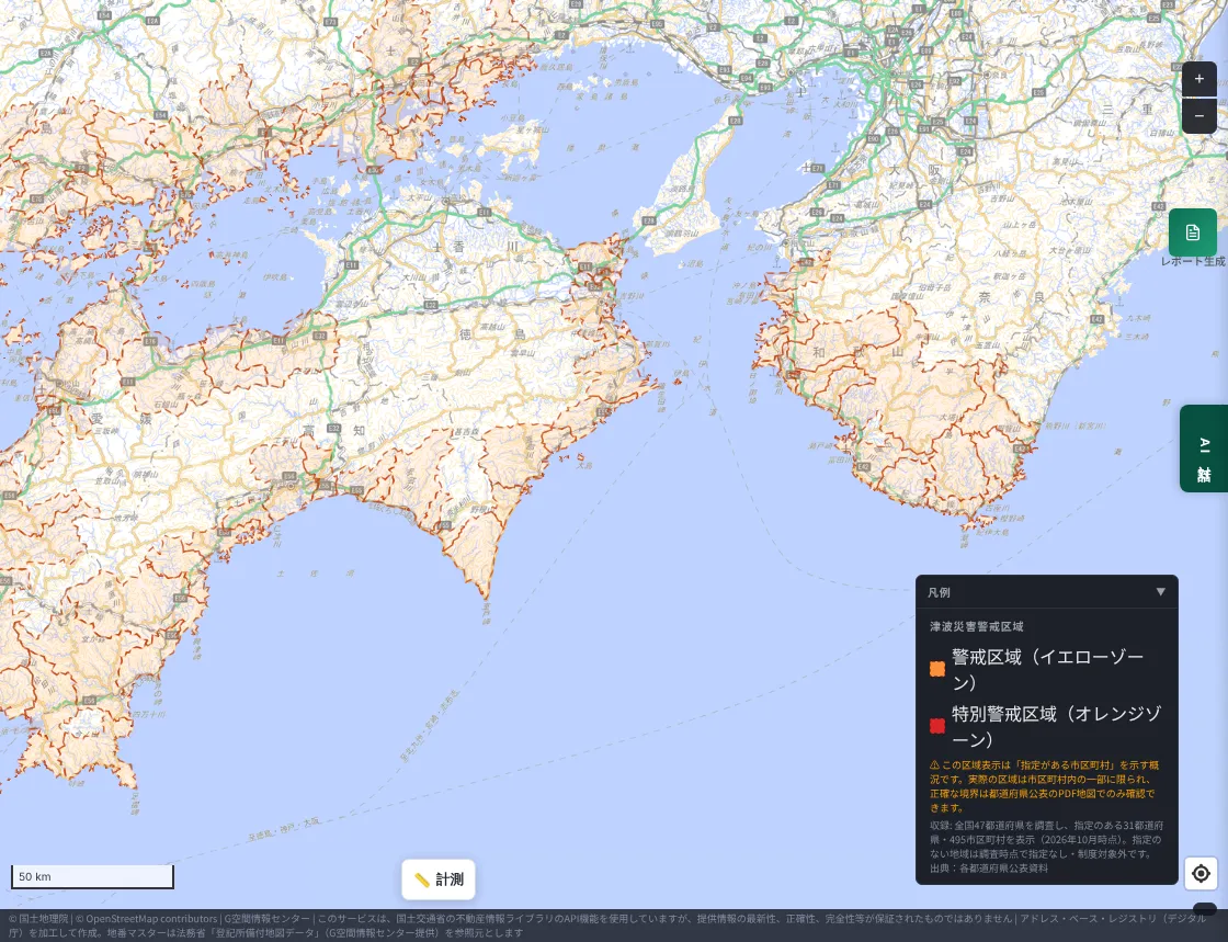
Kii Peninsula to Shikoku (Wakayama, Tokushima, Kochi)
In the Cabinet Office's 2012 estimate, a maximum tsunami height of 34 m was shown for Kuroshio Town, Kochi, which drew wide attention. On the southern Kii Peninsula and the Pacific coast of Shikoku, ria coastlines and a lack of flat land make evacuation to high ground especially important.
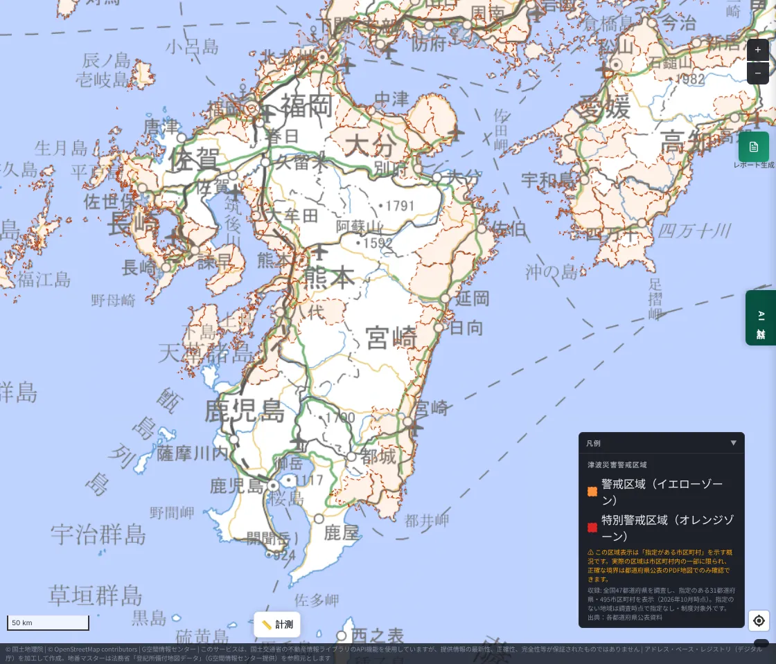
Kyushu (Oita, Miyazaki and others)
This is the area MAPRISE originally covered. The Hyuga-nada coast is known as an area close to the Nankai Trough source region. The existing coverage of the six Kyushu prefectures remains as it was in this expansion.
Will the Nankai Trough really come?
The risk of a Nankai Trough megathrust earthquake has been talked about for over 30 years, and it still hasn't come. Honestly, there are moments when even we wonder whether it might never come.
But on the long timescale of the Earth, 30 years is shorter than a blink. In January 2025, the government's Earthquake Research Committee raised the 30-year probability from "70–80%" to "about 80%". The Cabinet Office's 2025 estimate puts the worst-case death toll at about 298,000 and economic damage at about 292 trillion yen (the 2012 estimate for deaths was about 323,000). Once it happens, lives and every kind of asset are at stake. That is why advance preparation matters.
"Disasters strike when we have forgotten them"
There is a well-known Japanese saying: "Natural disasters come when you have forgotten them." Preparation tends to be thinnest just when memory fades.
National and local governments spend tax money to keep hazard information up to date, and estimates are revised as surveys progress. So rather than relying on an old hazard map you saw years ago, it is important to touch the latest data. We hope MAPRISE can help with that.
Limitations
- This layer shows whether a municipality has a designation; it is not the exact zone boundary.
- Municipalities not shown either had no designation at the time of the survey or are outside the system. This does not mean they are "safe".
- This is a separate system from tsunami inundation estimates; please check both.
- It is subject to the explanation of important matters in real estate transactions (Enforcement Regulations of the Real Estate Transaction Business Act, Art. 16-4-3), but final confirmation requires inquiry to the prefecture.
- The regional overviews are brief summaries of publicly available information. For individual evacuation plans, please refer to your municipality's hazard map and disaster plan.
Closing
Hazard information is worth revisiting each time it is updated. Please start by checking the area around your home, workplace, and places you often visit.
Questions and comments are welcome at info@maprise.jp.
The tsunami disaster warning area information in this post is reference information organized at the municipality level by MAPRISE (Vulcanz LLC) from materials published by each prefecture. It does not show exact zone boundaries and was not created or published by the prefectures. Maps are based on GSI Tiles from the Geospatial Information Authority of Japan.
Sources
- JST Science Portal, "Nankai Trough megathrust earthquake damage estimate (2025)"
- Cabinet Office (Disaster Management), Nankai Trough earthquake countermeasures
Tags: #Tsunami #Hazard map #Nankai Trough #Disaster prevention #Tsunami warning areas
Other-language share text (exception cases)
Quick share above follows our platform-locked language policy (X-family in Japanese, LinkedIn in English). The four panes below let you grab the opposite-language body when needed — e.g. introducing an English post to a Japanese audience on X, or posting a Japanese article to LinkedIn in Japanese. Each pane offers both a copy button and a direct intent link.
📝 津波災害警戒区域を全国の自治体に広げました ― 南海トラフが「来ない30年」のあいだに、備えを更新する
もともと九州6県だけだった津波災害警戒区域のデータを、全国47都道府県を調べて31都道府県495市区町村に広げました。太平洋側を中心に各地の状況を概説しながら、最新のハザード情報を確かめておく大切さをお伝えします。
https://maprise.jp/ja/blog/tsunami-zones-nationwide/ #津波 #ハザードマップ
🆕 新しいブログ記事を公開しました。

《津波災害警戒区域を全国の自治体に広げました ― 南海トラフが「来ない30年」のあいだに、備えを更新する》

もともと九州6県だけだった津波災害警戒区域のデータを、全国47都道府県を調べて31都道府県495市区町村に広げました。太平洋側を中心に各地の状況を概説しながら、最新のハザード情報を確かめておく大切さをお伝えします。

👉 詳しくはこちら: https://maprise.jp/ja/blog/tsunami-zones-nationwide/
📝 Tsunami Disaster Warning Areas, Now Nationwide — Updating Our Preparedness While the Nankai Trough Stays Quiet
Our tsunami disaster warning area data used to cover only six Kyushu prefectures. We surveyed all 47 prefectures and n…
https://maprise.jp/en/blog/tsunami-zones-nationwide/ #Tsunami #Hazardmap
🆕 New on the MAPRISE blog.

《Tsunami Disaster Warning Areas, Now Nationwide — Updating Our Preparedness While the Nankai Trough Stays Quiet》

Our tsunami disaster warning area data used to cover only six Kyushu prefectures. We surveyed all 47 prefectures and now include 495 municipalities in 31 prefectures. Here is an overview of conditions along the Pacific coast, and why checking the latest hazard information matters.

👉 Read the full post: https://maprise.jp/en/blog/tsunami-zones-nationwide/

#Tsunami #Hazardmap #NankaiTrough #Disasterprevention #Tsunamiwarningareas
Related posts
- Before You Think "The Water Won't Reach Here" — Disaster Monuments as Letters From the Past2026-07-26
- Two ways of looking at "fill land" — Embankment Regulation Zones and Large-scale Fill Land, now added2026-07-04
- "What if it rained even harder?" — seeing flood risk in stages, with the Multi-stage Flood Simulation layer2026-07-04