In Japan, disaster and land use have always come as a package. Volcanoes, earthquakes, typhoons. Most of the country is mountains, the rivers are steep, and flat land is scarce. We live on that scarce flat land, or on ground we cut and filled to make. Earlier generations carved what happened into stone. Here is why we put 278 natural disaster monuments across Kyushu on the map, and how to read them.
Hello from the MAPRISE team.
In Japan, disaster and land use have always come as a package. The country is surrounded by sea, has active volcanoes, sits on earthquake faults, and takes typhoons almost every year. Roughly two-thirds of the land is forest, and because the distance from mountain to sea is short, the rivers are steep. There was never much habitable flat land to begin with — so we build on that limited plain, on terraces, or on ground we have cut and filled to make buildable.
Which means "just choose land with no disaster risk" was never really an available strategy. What works instead is knowing what has already happened on that particular piece of ground.
Carving it into stone
When a major disaster struck, earlier generations built a monument so that later generations would know. Paper burns, memory fades, and the people who witnessed it eventually die. Carving into stone was, at the time, the most reliable way anyone knew to carry information across decades or centuries.
Since June 2019, the Geospatial Information Authority of Japan (GSI) has published these stones as "natural disaster monuments" (自然災害伝承碑) on its national map service, and created a new map symbol for them. The catalogue has since grown to 2,453 monuments across 683 municipalities nationwide (as of 23 July 2026).
MAPRISE has added the 278 monuments located in Kyushu's seven prefectures as a map layer. You will find it under Hazard & Disaster → Land History → Natural Disaster Monuments in the left menu.
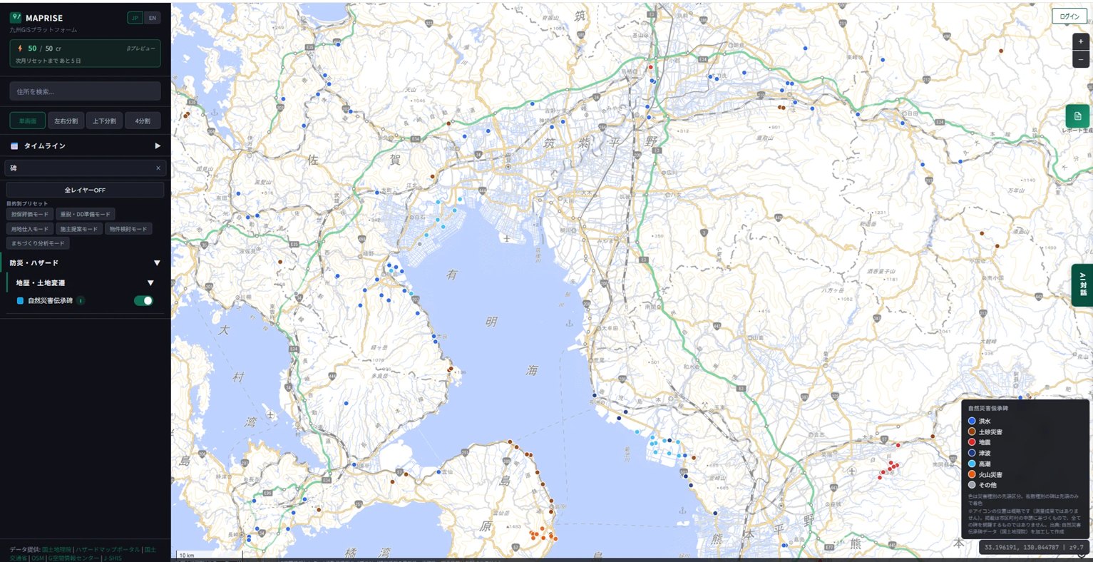
The legend tells you how varied the threat is
The part of this layer I most want people to look at is the legend.
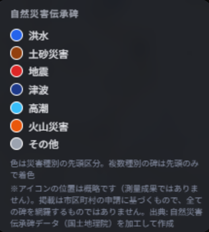
Flood, landslide, earthquake, tsunami, storm surge, volcanic disaster. Not many countries have monuments to all of these standing within a single region. And some stones record more than one disaster type — in those cases only the first category determines the colour, so the reality is even more compound than the map suggests.
Zoom out and the distribution itself carries meaning. Monuments cluster along the rivers of the plains, and volcanic monuments line the foot of the Shimabara Peninsula. Where the monuments are dense, the disasters repeated — the density of points says it directly.
Reading one of them
Along the Tade River in Kanzaki, Saga Prefecture, stands a "Disaster Recovery Monument" erected in 1959. Click the point on the map and you can read what was carved into it.
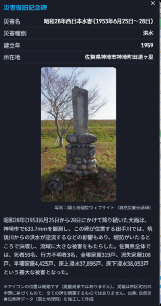
The stone records the Western Japan Flood of 1953. Rain fell continuously from 25 to 28 June, reaching 633.7 mm in Kanzaki. At the Tade River where this monument stands, floodwater backing up from the Chikugo River contributed to levees breaching in many places. Across Saga Prefecture the toll was 59 dead, 3 missing, 319 houses destroyed, 108 swept away, 4,425 partially destroyed, 37,895 flooded above floor level and 38,053 below.
That is more than 70,000 flooded homes, roughly seventy years ago, in the same place.
Using facts against normalcy bias
Disasters arrive once you have forgotten, as the saying goes. The harder problem is not the forgetting itself but that you cannot notice you have forgotten.
- It won't happen to me
- Surely the water won't reach this far
- It hasn't happened before, so it won't happen now
This is normalcy bias, and it operates on everyone. It is not a failure of willpower; it is simply how people are built.
If that is true, then trying to out-will it is less effective than keeping one concrete fact within reach. "This river breached seventy years ago and flooded 37,895 homes above floor level" lands far harder than "please take care during heavy rain." The monument is exactly that sentence, left standing at exactly that spot.
So if you ever pass nearby, go and look at the real thing. Reading it as a popup and reading it standing in front of weathered stone are not the same experience. These are letters written by earlier generations, addressed to us.
In practical due diligence
Monuments earn their place in property due diligence too. Hazard maps show what is projected; monuments show what actually happened. The two do different jobs, which is exactly why it is worth viewing them together.
In MAPRISE the layer sits in the same Hazard & Disaster group as the flood, landslide, tsunami and storm-surge inundation zones, so you can overlay the monuments on top of a projected zone. If a monument stands just outside the edge of a projected zone, that projection may be worth a second look.
Two caveats
Inclusion is based on municipal application. GSI does not survey the whole country itself; each municipality identifies the monuments in its area and applies to have them listed. The dataset is therefore not exhaustive. An absence of points does not mean no disaster occurred there — in municipalities that have not yet applied, monuments that physically exist may simply not be on the map.
Icon positions are approximate. They are not survey-grade, so allow for some offset if you go looking for a monument in the field.
Source: created by MAPRISE from the Geospatial Information Authority of Japan "Natural Disaster Monuments" dataset. Damage records are taken from the monument inscriptions and GSI's published information.
Tags: #Disaster monuments #Disaster prevention #Land history #GSI #Kyushu
Other-language share text (exception cases)
Quick share above follows our platform-locked language policy (X-family in Japanese, LinkedIn in English). The four panes below let you grab the opposite-language body when needed — e.g. introducing an English post to a Japanese audience on X, or posting a Japanese article to LinkedIn in Japanese. Each pane offers both a copy button and a direct intent link.
📝 「まさか、ここまでは来ない」と思う前に ― 自然災害伝承碑という、先人からの手紙
日本は、災害と土地利用がはじめからセットになっている国です。火山があり、地震があり、台風が来る。国土の多くは山で、川は急で、平野はわずかしかない。その限られた平地や、切り土・盛り土でつくった造成地の上に、私たちは住んでいます。先人はその教訓を石に刻んで残しました。九州7県278件の自然災害伝承碑を地図に載せた理由と、その読み方の話です。
https://maprise.jp/ja/blog/denshouhi-monuments/ #自然災害伝承碑 #防災
🆕 新しいブログ記事を公開しました。

《「まさか、ここまでは来ない」と思う前に ― 自然災害伝承碑という、先人からの手紙》

日本は、災害と土地利用がはじめからセットになっている国です。火山があり、地震があり、台風が来る。国土の多くは山で、川は急で、平野はわずかしかない。その限られた平地や、切り土・盛り土でつくった造成地の上に、私たちは住んでいます。先人はその教訓を石に刻んで残しました。九州7県278件の自然災害伝承碑を地図に載せた理由と、その読み方の話です。

👉 詳しくはこちら: https://maprise.jp/ja/blog/denshouhi-monuments/
📝 Before You Think "The Water Won't Reach Here" — Disaster Monuments as Letters From the Past
In Japan, disaster and land use have always come as a package. Volcanoes, earthquakes, typhoons. Most of the country i…
https://maprise.jp/en/blog/denshouhi-monuments/ #Disastermonuments #Disasterprevention
🆕 New on the MAPRISE blog.

《Before You Think "The Water Won't Reach Here" — Disaster Monuments as Letters From the Past》

In Japan, disaster and land use have always come as a package. Volcanoes, earthquakes, typhoons. Most of the country is mountains, the rivers are steep, and flat land is scarce. We live on that scarce flat land, or on ground we cut and filled to make. Earlier generations carved what happened into stone. Here is why we put 278 natural disaster monuments across Kyushu on the map, and how to read them.

👉 Read the full post: https://maprise.jp/en/blog/denshouhi-monuments/

#Disastermonuments #Disasterprevention #Landhistory #GSI #Kyushu
Related posts
- Two ways of looking at "fill land" — Embankment Regulation Zones and Large-scale Fill Land, now added2026-07-04
- "What if it rained even harder?" — seeing flood risk in stages, with the Multi-stage Flood Simulation layer2026-07-04
- See what's underground before you build — Borehole logs, now on MAPRISE!2026-06-27