MAPRISE has more than 50 layers, and picking the right ones for a given purpose, one by one, is genuinely tedious. So we built "Purpose Presets": six buttons, each tuned to a specific business scenario — collateral appraisal, disclosure prep, land acquisition, and more — that switch on the right set of layers with a single click. Here's exactly what each preset turns on.
Hello from the MAPRISE development team. This time it's an unglamorous feature — but one that, once you've used it, you won't want to go back from.
The luxury problem of having too many layers
MAPRISE offers more than 50 layers useful for real-estate, financial, and developer work across Kyushu — land prices, zoning, hazards, population statistics, 3D building models, and more. We're genuinely proud of that breadth, but the flip side is a real moment of friction: "I just want to look at the map for a collateral appraisal today — which layers do I actually need to turn on?" Scrolling down the left panel from the top, hunting for the layers that seem relevant, one at a time — that's its own kind of work.
One click, and the right set for the job is ready: "Purpose Presets"
So we built "Purpose Presets." At the top of the left panel, six buttons represent six business scenarios.

Click one button, and the layers commonly used in that scenario all switch on at once, with the relevant category automatically expanded. When you just want to see "something like collateral-appraisal information," you no longer have to go hunting through layer names one by one. Here's exactly what's inside each of the six presets.
Collateral Appraisal
Built for loan underwriting and collateral appraisal at financial institutions. It switches on five layers — tsunami inundation, geological map (AIST), official land price / prefectural land price survey points, land appraisal reports (XCT001), and PLATEAU buildings — and automatically expands the flood/sediment and seismic sub-groups under "Disaster Prevention / Hazards." It's a setup that lets you weigh the land-price data backing a collateral's value against the risks (tsunami, geology, earthquake) it carries, side by side.
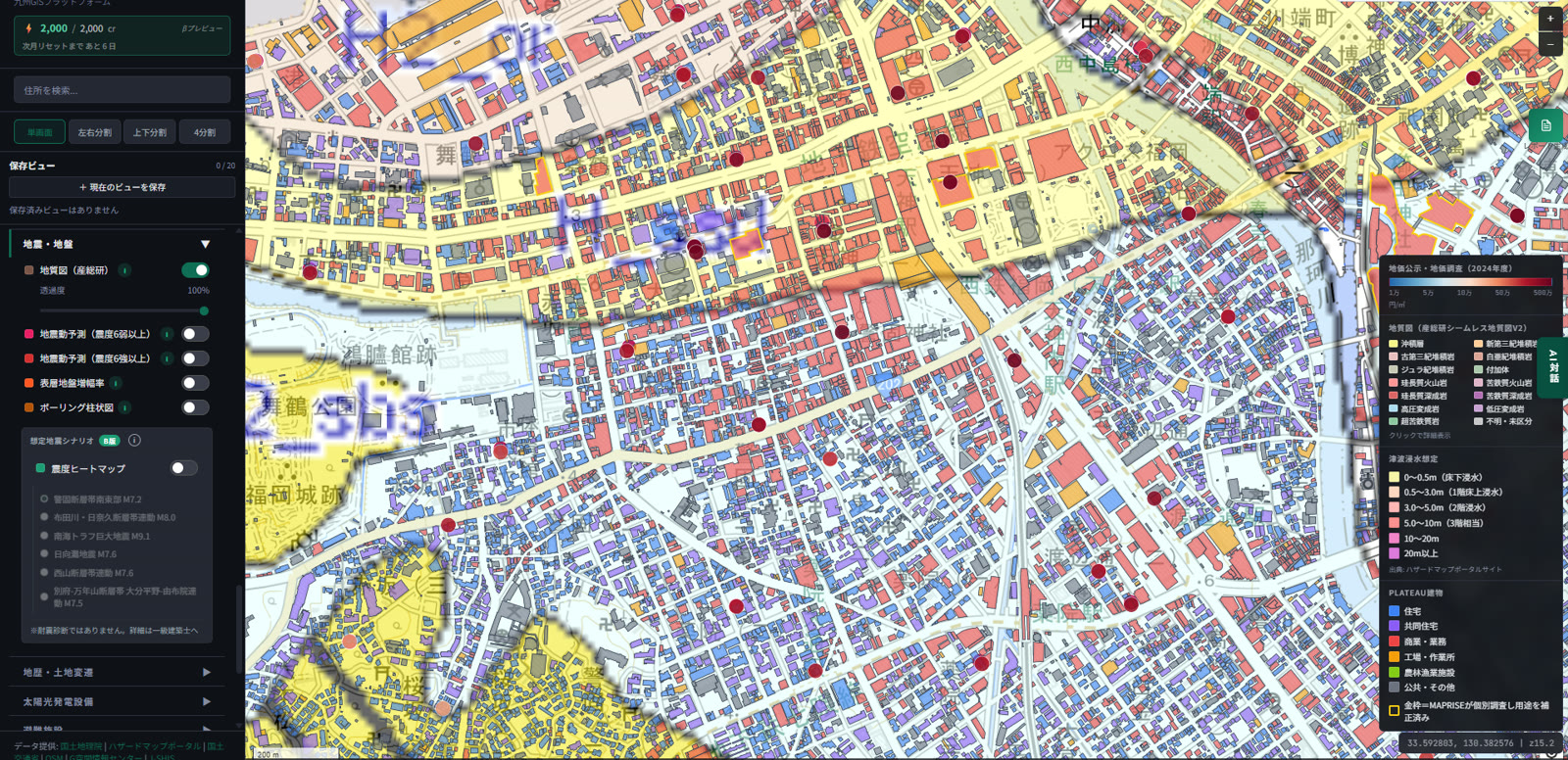
Press it over the Tenjin area, and this is what you get: geological rock classification, PLATEAU buildings color-coded by use, official land price and prefectural survey points (the red circles), and the tsunami inundation legend, all assembled on one screen. Work that would otherwise take several minutes of hunting for layers one by one is done with a single button.
Disclosure / DD Prep
Built for preparing a real-estate agent's mandatory disclosure statement, or real-estate due diligence. It switches on three layers — zoning (use districts), fire prevention zones, and the registry map (lot numbers) — and expands the base classification, historical hazard, and price-information categories. The idea is to assemble, in one shot, the regulatory and lot-number information you always have to check for a disclosure statement.
Land Acquisition
Built for homebuilders and developers evaluating a potential site. It switches on four layers — zoning, urbanization control area boundaries, unused land (Kitakyushu City), and the reference lot map (Kumamoto City) — and expands the "Future Forecast" category. Note that unused land and the reference lot map are currently reference data limited to specific municipalities (they won't appear outside those areas). This setup layers the legal constraints on how a site can be used against future population trends.
Client Proposal
Built for homebuilders presenting to a client. It switches on three layers — zoning, elementary school districts, and medical facilities — and expands the "Living Facilities / School Districts" category. It's built to instantly surface the everyday reassurance points: which school district a given area falls into, and what medical facilities sit nearby.
Property Review
Built for evaluating an individual property. It switches on three layers — flood inundation (assumed maximum scale), tsunami inundation, and elementary school districts — and expands both the "Living Facilities / School Districts" and "Crime Prevention / Safety" categories. It lets you check flood risk and everyday living conditions on the same screen.
Urban Planning
Built for municipal staff or anyone assessing an area's long-term prospects. It switches on three layers — Densely Inhabited District (DID), location normalization plan areas, and the municipal fiscal-strength index — and expands the "Future Forecast" category. This lines up population concentration, compact-city policy target areas, and a municipality's fiscal health side by side.
Getting the "quick check" done, matched to how each industry actually works
What we want this feature to convey isn't just time savings. Every industry has a set of standard checks it never skips — the things a real-estate agent always confirms before a disclosure statement, what a bank always checks for collateral appraisal, what a developer always surveys before acquiring land. Purpose Presets pre-assemble those standard patterns on MAPRISE's side, so that even in a "let me just take a quick look" moment, you can cover the industry-standard checkpoints, completely, with a single click.
Of course, once a preset has loaded, you're free to add more layers or turn off ones you don't need. Think of it as a starting point — a way to cut down the time spent wondering where to start, not the final word on what to look at.
We'll keep working on ways to cut down the effort of hunting for the right layer.
The composition of these presets may change as we continue to improve them. Some layers, such as unused land and the reference lot map, are currently limited to specific municipalities.
Tags: #Purpose presets #UI/UX #Layer management #How-to
Other-language share text (exception cases)
Quick share above follows our platform-locked language policy (X-family in Japanese, LinkedIn in English). The four panes below let you grab the opposite-language body when needed — e.g. introducing an English post to a Japanese audience on X, or posting a Japanese article to LinkedIn in Japanese. Each pane offers both a copy button and a direct intent link.
📝 50超あるレイヤー、全部覚えなくていい ― 目的別プリセットでワンクリック一括ON
MAPRISEには50を超えるレイヤーがあり、目的に応じて一つひとつ選ぶのは正直しんどい作業です。そこで用意したのが「目的別プリセット」。担保評価・重説準備・用地仕入など、6つの業務シーンに合わせて必要なレイヤーをワンクリックで一括ONにできます。それぞれのプリセットが何を表示するのか、実際の構成とあわせてご紹介します。
https://maprise.jp/ja/blog/purpose-preset-layers/ #目的別プリセット #UI/UX
🆕 新しいブログ記事を公開しました。

《50超あるレイヤー、全部覚えなくていい ― 目的別プリセットでワンクリック一括ON》

MAPRISEには50を超えるレイヤーがあり、目的に応じて一つひとつ選ぶのは正直しんどい作業です。そこで用意したのが「目的別プリセット」。担保評価・重説準備・用地仕入など、6つの業務シーンに合わせて必要なレイヤーをワンクリックで一括ONにできます。それぞれのプリセットが何を表示するのか、実際の構成とあわせてご紹介します。

👉 詳しくはこちら: https://maprise.jp/ja/blog/purpose-preset-layers/

#UI/UX
📝 You don't need to memorize 50+ layers — one-click Purpose Presets turn on exactly what you need
MAPRISE has more than 50 layers, and picking the right ones for a given purpose, one by one, is genuinely tedious. So we built "Pu…
https://maprise.jp/en/blog/purpose-preset-layers/ #Purposepresets #UI/UX
🆕 New on the MAPRISE blog.

《You don't need to memorize 50+ layers — one-click Purpose Presets turn on exactly what you need》

MAPRISE has more than 50 layers, and picking the right ones for a given purpose, one by one, is genuinely tedious. So we built "Purpose Presets": six buttons, each tuned to a specific business scenario — collateral appraisal, disclosure prep, land acquisition, and more — that switch on the right set of layers with a single click. Here's exactly what each preset turns on.

👉 Read the full post: https://maprise.jp/en/blog/purpose-preset-layers/

#Purposepresets #UI/UX #Layermanagement #How-to
Related posts
- "Transaction price" vs. "contract price" — do you know the difference? MAPRISE's real-estate price map now tells them apart by icon shape2026-07-04
- Reading 1.55 million Kyushu buildings through three lenses — how to use the PLATEAU Buildings layer2026-07-11
- Why every official land appraisal has two appraisers — looking behind Japan's Land Price Publication with MAPRISE2026-07-04