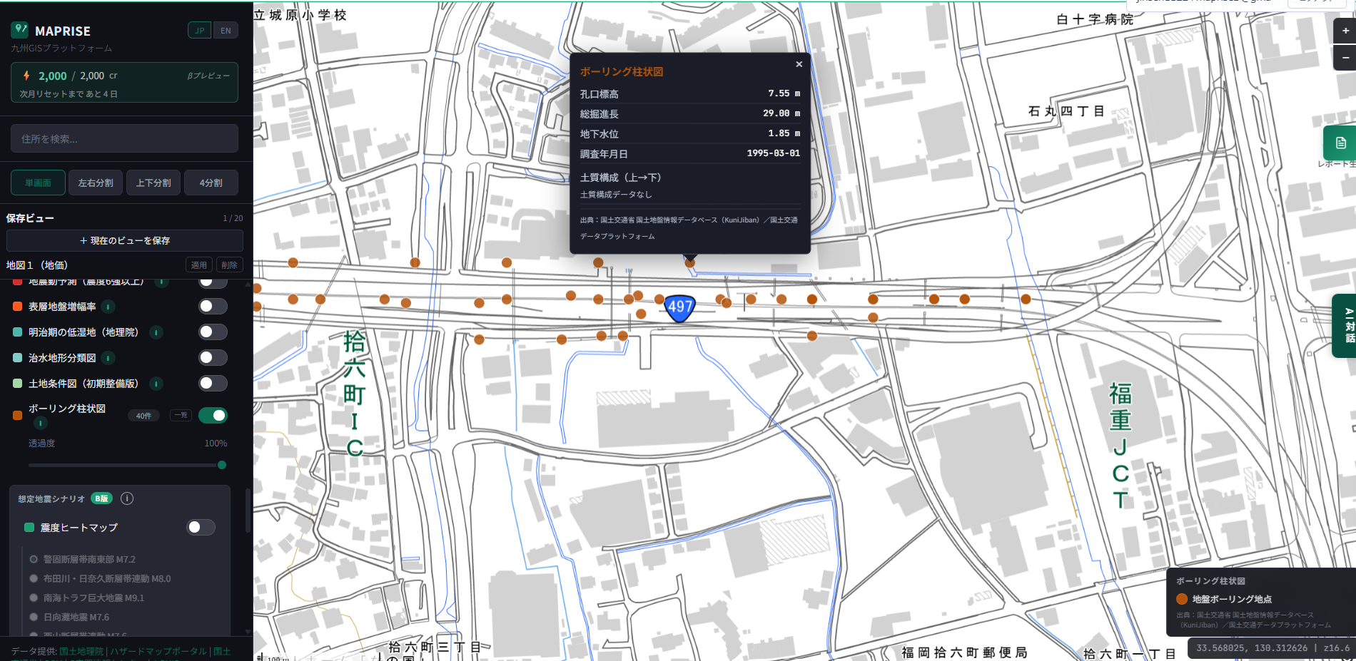
We've added borehole-log data for all seven Kyushu prefectures to MAPRISE. Click one of the orange points on the map and the ground elevation, total drilling depth, groundwater level, survey date, and soil profile pop right up — primary-source information for checking what's beneath a site before you build, lease, or buy.
Hello from the MAPRISE development team. Today, let us start with a "we did it!" report. We've loaded borehole-log data for all seven Kyushu prefectures into MAPRISE. Those orange points lined up across the map — each one is a record of "what's actually beneath this piece of ground." Click one, and the ground elevation, total drilling depth, groundwater level, survey date, and soil profile pop right open. It looks unassuming, but this is data that quietly does a lot of work.
So what exactly is a borehole log?
In a word, it's "a cross-sectional chart of the ground — a record made by drilling a thin hole and noting, from top to bottom, how the layers of soil are stacked." Is it sand, clay, or gravel? At what depth is the groundwater? And where is the firm layer (the bearing stratum) that will support the weight of a building? All of this is laid out as a single diagram along the depth axis. Where a surface hazard map tells you about "the risk at ground level," a borehole log tells you about "what the ground is made of." The vantage point is completely different.
Who uses it, and when?
The ones we expect to be happiest are home builders and construction firms. When you acquire a plot, whether a building can sit on it without trouble — and roughly how much ground improvement might cost — has a big effect on the bottom line. If there's borehole data nearby, you can size things up before the site survey: "the soft layer is thick around here, so let's budget for improvement," or "there's a firm layer close to the surface, so conditions look good." A full geotechnical survey comes after the contract, but it's the appraisal that happens just before it where this primary-source data really earns its keep.
For real-estate agents, it becomes material for explaining things to clients. Being able to say "the ground in this area tends to behave like this," backed by objective public data, inspires a different level of confidence. In collateral valuation at financial institutions, too, the quality of the ground is one factor that affects land value. Grasping early on whether a site carries liquefaction or subsidence risk improves the precision of the review. And for individuals considering a home of their own: the biggest purchase of your life, and what literally lies beneath its feet. Being able to peek at that before you buy is, in truth, a real luxury.
How does MAPRISE make it more useful?
The borehole data itself is reliable public data, published through the national KuniJiban (the National Geotechnical Information Search Site). What we're proud of, though, is that MAPRISE lets you view it on the map, overlaid in a single screen with other layers — land prices, hazards, zoning, projected earthquake shaking. The question "the land price is high, but what about the ground?" can be answered without switching screens. Click a point and you can read the stacking of soil layers right there. Use the split screen and you can compare the ground of candidate sites A and B side by side.
One thing, in all honesty. In this first release, you can view each point's elevation, drilling depth, groundwater level, survey year, and soil profile. The N-value at each depth (a figure expressing how firm the ground is) is something we plan to keep adding. Once that's in, "how many meters down you reach the bearing stratum" will come into even sharper focus. Stay tuned, as they say.
Nobody usually looks beneath the ground. But buildings are held up by exactly that unseen part. See before you build. See before you lease. See before you buy. If this becomes one step toward making that obvious thing a little easier, we'll be glad. We'll keep adding data and polishing it. If you want to know the risk of land created by embankment, see embankment regulation zones and large-scale fill land.
Please use this data as primary-source, reference information. For actual design and transactions, a separate formal geotechnical survey and confirmation by experts are required.
Source: National Geotechnical Information Search Site (KuniJiban) / MLIT Data Platform (CC BY 4.0)
Tags: #Ground #Borehole logs #KuniJiban #Disaster prevention #Data update
Other-language share text (exception cases)
Quick share above follows our platform-locked language policy (X-family in Japanese, LinkedIn in English). The four panes below let you grab the opposite-language body when needed — e.g. introducing an English post to a Japanese audience on X, or posting a Japanese article to LinkedIn in Japanese. Each pane offers both a copy button and a direct intent link.
📝 地面の下を、ちゃんと見てから建てよう ― ボーリング柱状図、対応しました!
九州 7 県のボーリング柱状図データを MAPRISE に投入しました。地図上に並ぶオレンジの点をクリックすると、孔口標高・総掘進長・地下水位・調査年月日・土質構成がパッと開きます。地面の中身を、建てる前・貸す前・買う前に確かめるための一次情報です。
https://maprise.jp/ja/blog/ground-boring-kunijiban/ #地盤 #ボーリング柱状図
🆕 新しいブログ記事を公開しました。

《地面の下を、ちゃんと見てから建てよう ― ボーリング柱状図、対応しました!》

九州 7 県のボーリング柱状図データを MAPRISE に投入しました。地図上に並ぶオレンジの点をクリックすると、孔口標高・総掘進長・地下水位・調査年月日・土質構成がパッと開きます。地面の中身を、建てる前・貸す前・買う前に確かめるための一次情報です。

👉 詳しくはこちら: https://maprise.jp/ja/blog/ground-boring-kunijiban/

#KuniJiban
📝 See what's underground before you build — Borehole logs, now on MAPRISE!
We've added borehole-log data for all seven Kyushu prefectures to MAPRISE. Click one of the orange points on the map and the ground elevation, total drill…
https://maprise.jp/en/blog/ground-boring-kunijiban/ #Ground #Boreholelogs
🆕 New on the MAPRISE blog.

《See what's underground before you build — Borehole logs, now on MAPRISE!》

We've added borehole-log data for all seven Kyushu prefectures to MAPRISE. Click one of the orange points on the map and the ground elevation, total drilling depth, groundwater level, survey date, and soil profile pop right up — primary-source information for checking what's beneath a site before you build, lease, or buy.

👉 Read the full post: https://maprise.jp/en/blog/ground-boring-kunijiban/

#Ground #Boreholelogs #KuniJiban #Disasterprevention #Dataupdate
Related posts
- Two ways of looking at "fill land" — Embankment Regulation Zones and Large-scale Fill Land, now added2026-07-04
- "What if it rained even harder?" — seeing flood risk in stages, with the Multi-stage Flood Simulation layer2026-07-04
- Before You Think "The Water Won't Reach Here" — Disaster Monuments as Letters From the Past2026-07-26