We've added Land-alteration Work Regulation Areas / Specified Fill-land Regulation Areas (under Japan's embankment regulation law) and Large-scale Fill Land (valley-fill and slope-attached types) layers for all 7 Kyushu prefectures. These look similar but describe two very different things — "regulation on future fill work" versus "ground risk on existing developed land." Here's how MAPRISE displays both.
Hello from the MAPRISE development team. This time we've added two new layers related to "fill land" (morido): "Land-alteration Work Regulation Areas / Specified Fill-land Regulation Areas" (7 Kyushu prefectures) and "Large-scale Fill Land" (7 Kyushu prefectures). Both are about fill land, but they actually point to quite different things. Let's untangle that as we walk through them.
What is the embankment regulation law?
Following the 2021 debris-flow disaster in the Izusan district of Atami City, Japan enacted a law aimed at protecting lives from disasters caused by embankments and fill work — the "Act on Regulation of Residential Land Development, etc." (commonly known as the embankment regulation law), which took effect in May 2023. Prefectural governors and other authorities designate "areas where fill work, etc. could cause damage to homes and other structures" as regulation zones. Within these zones, a permit or notification is required in advance for any fill, cut, or soil/rock deposition work above a certain scale.
The first layer we've added to MAPRISE is this regulation zone itself. It comes in three types: Land-alteration Work Regulation Areas (areas such as urban districts where homes already stand), Specified Fill-land Regulation Areas (slopes and other terrain where the topography could cause damage to nearby homes), and Unclassified / Other areas where the source data doesn't distinguish the type. Coverage spans Fukuoka, Nagasaki, Kumamoto, Oita, Miyazaki, and Kagoshima prefectures (Saga is excluded, as it has designated no regulation zones), using FY2025 data.
Because Kyushu is largely mountainous, Specified Fill-land Regulation Areas (covering slopes) tend to be designated over a larger area than Land-alteration Work Regulation Areas (covering urban districts) — especially in Kumamoto, Oita, Miyazaki, and Kagoshima. Fukuoka Prefecture, by contrast, stands out for having more Land-alteration Work Regulation Area designations. When acquiring a site, whether it falls within one of these zones affects whether permits or notifications will be needed for development work — making it a useful thing to check early on.
What is large-scale fill land? (A separate concept from the regulation zones)
The second layer, large-scale fill land, describes something similar-sounding but distinct from the regulation zones. Where the regulation zones govern "future fill work that's about to happen," large-scale fill land describes "existing residential land that was already created in the past by filling in a valley or slope with earth." In other words, this isn't about a place where something is planned — it's data showing the ground risk of developed land where people already live.
There are two types: valley-fill, where a valley or ravine was filled in with earth to create the land, and slope-attached fill, where earth was banked against a sloped area to create it. Large-scale fill land has been flagged as a site where an earthquake can trigger "landslide-like slumping" — the entire fill mass shifting like a landslide — and damage to this kind of developed land was actually confirmed in the 2016 Kumamoto earthquake. Coverage spans all 7 Kyushu prefectures, using FY2023 data. This is useful not only for judging whether new construction is feasible, but also for estimating ground-improvement costs on existing developed land.
What MAPRISE shows: what you can see on the map
Let's look at an actual screen — an example around Fukuoka City's Jonan and Minami wards.
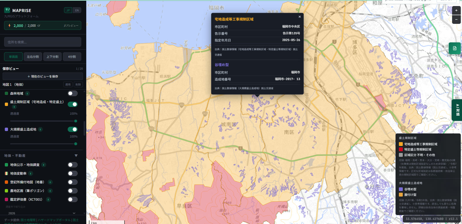
The broad amber-colored area is the Land-alteration Work Regulation Area, the red area is the Specified Fill-land Regulation Area, and the small purple polygons are large-scale fill land (valley-fill type). Click a point and every layer overlapping that location appears together in one popup. In the screenshot above, both a "Land-alteration Work Regulation Area" (municipality, notice number, designation date) and a "valley-fill" large-scale fill land entry (municipality, fill-land ID) are shown at once — making it immediately clear that the regulation zone and the existing developed-land risk overlap at the same spot.
In the left panel, you can toggle the two layers independently and adjust their opacity separately. The legend in the bottom-right corner shows the color coding for both layers together.
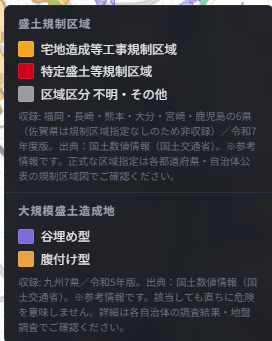
As noted in the legend, both layers are reference information covering only a limited set of prefectures. An area not shown does not mean no risk — for the official zone designations and detailed ground information, please check your prefecture's or municipality's published materials and geotechnical surveys.
In summary: two similar-looking but distinct pieces of information, seen together
"Embankment regulation zones" tell you whether a legal regulation applies; "large-scale fill land" tells you how the ground itself came to be. These are two different vantage points. Being able to overlay both on a single map lets you check, at the same time, "is this site inside a regulation zone?" and "was this site created by filling in earth in the past?" — sharpening the accuracy of site-acquisition feasibility checks, construction planning, and ground-improvement cost estimates.
We'll keep adding more ground-related data. To dig further into the ground itself, see borehole logs; to layer this against another hazard, see multi-stage flood simulation.
This data is provided for reference, based on National Land Numerical Information (Land-alteration Work Regulation Areas / Specified Fill-land Regulation Areas, and Large-scale Fill Land). For official zone designations and detailed ground information, please check materials published by your prefecture or municipality, along with a professional geotechnical survey.
Source: National Land Numerical Information (Land-alteration Work Regulation Areas / Specified Fill-land Regulation Areas), FY2025 edition; National Land Numerical Information (Large-scale Fill Land), FY2023 edition; MLIT
Tags: #Embankment regulation law #Large-scale fill land #Ground #Disaster prevention #Data update
Other-language share text (exception cases)
Quick share above follows our platform-locked language policy (X-family in Japanese, LinkedIn in English). The four panes below let you grab the opposite-language body when needed — e.g. introducing an English post to a Japanese audience on X, or posting a Japanese article to LinkedIn in Japanese. Each pane offers both a copy button and a direct intent link.
📝 「盛土」を2つの角度から見る ― 盛土規制区域と大規模盛土造成地、レイヤーを追加しました
宅地造成等工事規制区域・特定盛土等規制区域(盛土規制法)と、大規模盛土造成地(谷埋め型・腹付け型)のレイヤーを九州7県に追加しました。「これから盛土する際の規制」と「すでにある造成地の地盤リスク」という、似ているようで別の2つの情報を、MAPRISE上でどう表示しているかご紹介します。
https://maprise.jp/ja/blog/morido-regulation-and-fill-land/ #盛土規制法 #大規模盛土造成地
🆕 新しいブログ記事を公開しました。

《「盛土」を2つの角度から見る ― 盛土規制区域と大規模盛土造成地、レイヤーを追加しました》

宅地造成等工事規制区域・特定盛土等規制区域(盛土規制法)と、大規模盛土造成地(谷埋め型・腹付け型)のレイヤーを九州7県に追加しました。「これから盛土する際の規制」と「すでにある造成地の地盤リスク」という、似ているようで別の2つの情報を、MAPRISE上でどう表示しているかご紹介します。

👉 詳しくはこちら: https://maprise.jp/ja/blog/morido-regulation-and-fill-land/
📝 Two ways of looking at "fill land" — Embankment Regulation Zones and Large-scale Fill Land, now added
We've added Land-alteration Work Regulation Areas / Specified Fill-land Regulation Areas (under Japan…
https://maprise.jp/en/blog/morido-regulation-and-fill-land/ #Embankmentregulationlaw #Large-scalefillland
🆕 New on the MAPRISE blog.

《Two ways of looking at "fill land" — Embankment Regulation Zones and Large-scale Fill Land, now added》

We've added Land-alteration Work Regulation Areas / Specified Fill-land Regulation Areas (under Japan's embankment regulation law) and Large-scale Fill Land (valley-fill and slope-attached types) layers for all 7 Kyushu prefectures. These look similar but describe two very different things — "regulation on future fill work" versus "ground risk on existing developed land." Here's how MAPRISE displays both.

👉 Read the full post: https://maprise.jp/en/blog/morido-regulation-and-fill-land/

#Embankmentregulationlaw #Large-scalefillland #Ground #Disasterprevention #Dataupdate
Related posts
- See what's underground before you build — Borehole logs, now on MAPRISE!2026-06-27
- "What if it rained even harder?" — seeing flood risk in stages, with the Multi-stage Flood Simulation layer2026-07-04
- Before You Think "The Water Won't Reach Here" — Disaster Monuments as Letters From the Past2026-07-26