Japan's Official Land Price Publication and Prefectural Land Price Survey actually have two independent real-estate appraisers evaluate every reference point. We walk through why two appraisers, what the "three-approach" valuation method is, and why plotting it all on a map in MAPRISE is so useful — with screenshots along the way.
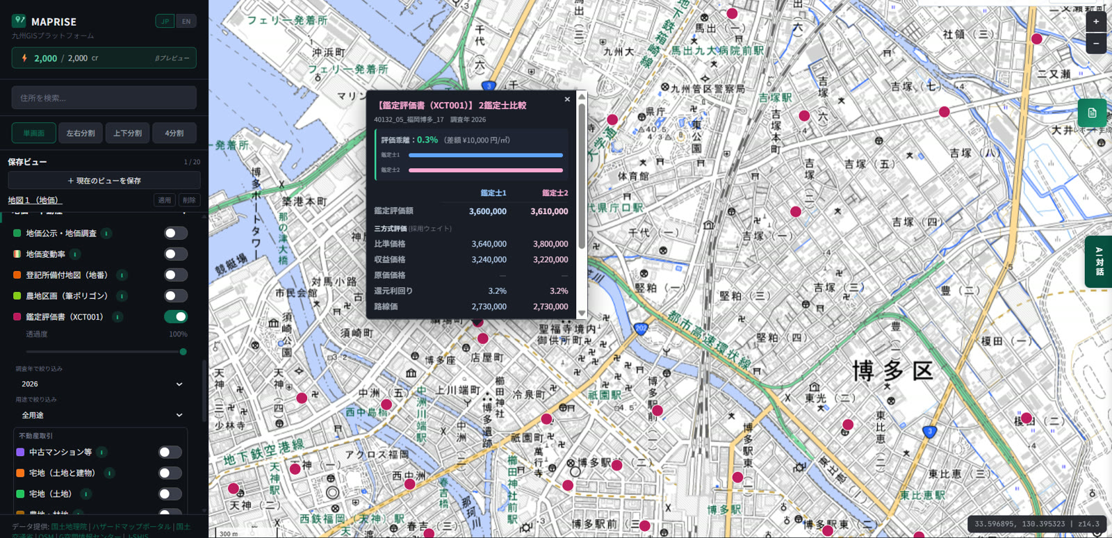
Hello from the MAPRISE development team. Today's topic is the "appraisal report" layer. You've probably seen the red pins plotted on the map for the "Appraisal Report (XCT001)" layer — have you ever clicked one? The popup has a small twist: for a single point, you get two full valuations side by side, from Appraiser 1 and Appraiser 2.
Why two appraisers?
Are you familiar with Japan's Official Land Price Publication and Prefectural Land Price Survey? These are systems in which the national and prefectural governments select representative "reference points" (hyojunchi) across the country and publish their normal market price as of January 1 (Land Price Publication) or July 1 (Land Price Survey) each year. When the news reports "land prices rose X% this year," this is the underlying data.
A key feature of this system: at least two real-estate appraisers, working independently of each other, must appraise every single reference point. If a price were left to one appraiser's subjective judgment alone, the objectivity and reliability required of an official price would be undermined. So two appraisers each conduct their own independent research and analysis, their figures are cross-checked, and only then is the final published price (or benchmark price) determined. A built-in "double-check" mechanism sits behind a number as publicly consequential as land price.
MAPRISE visualizes exactly this two-appraiser structure. Open the popup and you'll see Appraiser 1's and Appraiser 2's valuations side by side, with a valuation gap (percentage difference and yen/m² difference) shown as a bar graph at the top. Across the real data, about 87% of Kyushu's 11,680 reference points show a gap under 1% — meaning the two appraisers reached nearly identical conclusions. Conversely, points with a larger gap (3% or more, roughly 1% of all points) may be sites where the pricing factors are more complex, or the market is in flux — worth a closer look.
So what is this "three-approach valuation," anyway?
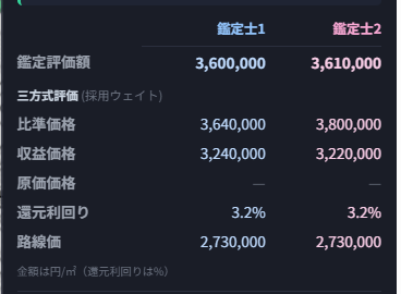
Inside the popup, you'll find three numbers listed: "comparison price," "income price," and "cost price." These correspond to the three approaches to valuation defined by Japan's Real Estate Appraisal Standards.
- Comparison price (sales comparison approach): derived by collecting actual transaction cases near the subject site and adjusting for differences in timing, location, and individual conditions. This is the primary approach for actively traded land, such as residential and commercial areas.
- Income price (income capitalization approach): derived by discounting the income (e.g., rent) the land or building is expected to generate in the future, using a capitalization rate. This carries the most weight for income-producing properties like rental offices and apartments. The "capitalization rate" shown in the popup is the rate used in this calculation.
- Cost price (cost approach): derived by calculating how much it would cost to newly construct the building today (replacement cost), then subtracting the value lost to aging and other factors.
Appraisers compare and reconcile the trial prices from all three approaches to arrive at a final valuation. Relying on a single approach isn't the point — cross-checking from multiple angles is the essence of appraisal. The "weighting applied" note in the popup reflects how much each approach was emphasized, based on the character of the subject site. The "roadside land price" shown alongside is a separate official price used for inheritance and property tax assessment, and also serves as a rough benchmark for sanity-checking the appraised value.
What do you learn from seeing it plotted on a map?
An appraisal report is, by nature, a standalone PDF or paper document tied to a single point. Lining these up on a map surfaces things that a single point's data never would on its own.
First, you get an at-a-glance view of the distribution of price levels across an area — how much valuations vary point to point within the same ward or around the same station, and where the high-price areas cluster. Second, points with a large valuation gap become visible on the map — a sign that pricing was harder to pin down, or that the market may be in transition, and worth examining alongside nearby transaction trends. And because MAPRISE lets you overlay this layer with the Land Price Publication/Survey, real-estate transaction prices (including contract prices), and zoning layers, you can check in a single screen whether an appraised value is consistent with nearby transaction levels and the zoning's floor-area ratio. The survey-year and use-type filters in the left panel also let you narrow down by year or property type.
Who does this help in practice?
This data is especially useful for anyone who needs to establish a fair price for a piece of real estate.
For loan underwriting and collateral appraisal staff at financial institutions, being able to check the appraised value along with the method used and the valuation gap is a useful input for verifying whether a collateral valuation holds up. For real-estate agents, knowing the surrounding official appraisal levels gives an objective basis when explaining pricing to clients. For developers, being able to see the trend of appraised values around a candidate site — as an area, not just a point — helps in the early stages of feasibility assessment for land acquisition. For real-estate investors, comparing income prices and capitalization rates across regions is one useful reference point (it is not intended as a basis for investment decisions themselves — please confirm final decisions with a qualified professional).
One thing worth stressing here: what MAPRISE provides is a visualization of published appraisal information, for reference purposes. If you need a legally binding appraisal for a specific property, you must obtain a formal appraisal from a licensed real-estate appraiser.
It looks unassuming, but the figure we call "land price" is put together with real care. We'll keep making the perspective of those two appraisers behind it easier to see. If you want to see prices grounded in actual transactions, check out transaction price vs. contract price, or for a concrete example of land-price movement, how TSMC's arrival moved prices in Kikuyo Town.
This data is provided for reference, based on appraisal information from Japan's Official Land Price Publication and Prefectural Land Price Survey. A legally binding appraisal can only be performed by a licensed real-estate appraiser. For individual valuation or investment decisions, please consult a real-estate appraiser or other qualified professional.
Source: MLIT Official Land Price Publication / Prefectural Land Price Survey, Real Estate Appraisal Standards (MLIT)
Tags: #Appraisal report #Land Price Publication #Land Price Survey #XCT001 #Three-approach valuation
Other-language share text (exception cases)
Quick share above follows our platform-locked language policy (X-family in Japanese, LinkedIn in English). The four panes below let you grab the opposite-language body when needed — e.g. introducing an English post to a Japanese audience on X, or posting a Japanese article to LinkedIn in Japanese. Each pane offers both a copy button and a direct intent link.
📝 なぜ鑑定評価は「2人の鑑定士」で行われるのか ― 地価公示・地価調査の裏側をMAPRISEで見てみる
地価公示・地価調査は、実は1つの標準地につき2人の不動産鑑定士が独立して評価しています。なぜ2人なのか、三方式評価とは何なのか、そしてMAPRISEに地図としてプロットされているとなぜ便利なのかを、画面キャプチャを見ながらやさしく解説します。
https://maprise.jp/ja/blog/land-appraisal-two-appraisers/ #鑑定評価書 #地価公示
🆕 新しいブログ記事を公開しました。

《なぜ鑑定評価は「2人の鑑定士」で行われるのか ― 地価公示・地価調査の裏側をMAPRISEで見てみる》

地価公示・地価調査は、実は1つの標準地につき2人の不動産鑑定士が独立して評価しています。なぜ2人なのか、三方式評価とは何なのか、そしてMAPRISEに地図としてプロットされているとなぜ便利なのかを、画面キャプチャを見ながらやさしく解説します。

👉 詳しくはこちら: https://maprise.jp/ja/blog/land-appraisal-two-appraisers/

#XCT001
📝 Why every official land appraisal has two appraisers — looking behind Japan's Land Price Publication with MAPRISE
Japan's Official Land Price Publication and Prefectural Land Price Survey actually have two inde…
https://maprise.jp/en/blog/land-appraisal-two-appraisers/ #Appraisalreport #LandPricePublication
🆕 New on the MAPRISE blog.

《Why every official land appraisal has two appraisers — looking behind Japan's Land Price Publication with MAPRISE》

Japan's Official Land Price Publication and Prefectural Land Price Survey actually have two independent real-estate appraisers evaluate every reference point. We walk through why two appraisers, what the "three-approach" valuation method is, and why plotting it all on a map in MAPRISE is so useful — with screenshots along the way.

👉 Read the full post: https://maprise.jp/en/blog/land-appraisal-two-appraisers/

#Appraisalreport #LandPricePublication #LandPriceSurvey #XCT001 #Three-approachvaluation
Related posts
- You don't need to memorize 50+ layers — one-click Purpose Presets turn on exactly what you need2026-07-26
- Reading 1.55 million Kyushu buildings through three lenses — how to use the PLATEAU Buildings layer2026-07-11
- "Transaction price" vs. "contract price" — do you know the difference? MAPRISE's real-estate price map now tells them apart by icon shape2026-07-04