The number of golf courses in Japan is about 10% below its peak. We looked at seven former courses across the country where solar panels now cover the land, using MAPRISE's 4-panel view: AI panel detection, today's aerial photo, a past aerial photo (or past land use), and a color elevation map.
Hello, this is the MAPRISE development team. This time we looked for places in Japan where land that used to be a golf course is now covered with solar panels. We also looked into how many golf courses have disappeared compared with the peak.
Some parts of this article, such as why courses close and how the land is used afterwards, include my own guesses. It is not an evaluation of any particular course or operator. I hope you can read it as a gentle introduction to what a map can tell us.
How Many Golf Courses Have Disappeared Since the Peak?
As far as I could find, the number of golf courses in operation has changed as follows (figures reported from the survey by Ikki Publishing's "Golf Tokushin"):
- 2004, the peak: 2,356 courses
- 2023: 2,123 courses
- September 2024: 2,121 courses (235 fewer than the peak, about 10.0% down)
- August 2025: 2,110 courses (246 fewer than the peak, about 10.4% down)
So, compared with the peak, there is a net decrease of about 250 courses, roughly one in ten. The number has fallen almost every year since 2008, and the pace is said to have quickened after the Great East Japan Earthquake. Because some new courses opened in the meantime, the number of courses that actually closed is probably larger than this net figure.
Counts also differ slightly depending on who surveys and how they count. For example, statistics from the Japan Golf Course Business Association and others describe 2002, with 2,460 courses, as the peak. It may be best to take "about 10% fewer" as the general trend.
The Number of Golfers Has Fallen Too
Alongside the number of courses, the number of people who play matters. According to the "Leisure White Paper" by the Japan Productivity Center, participation in golf (on courses) has been reported as follows:
- 1994: about 14.5 million (the peak)
- 2015: about 7.6 million
- 2019–2020: about 5.2 million
- 2024: about 4.8 million
Over roughly 30 years, that is a fall to about one third of the peak. The number of players has fallen much more than the number of courses (about 10%).
Solar Power Seems to Have Been a Common Use for the Land
Closed courses become housing, parks, farmland, or are simply left as they are. Among these, solar power plants do not seem to be rare. An article from the 2010s (Diamond Online) reported that "Golf Tokushin" had covered about 150 cases of golf course land turning into mega solar since 2011 (including partial conversions and plans). It also noted that cases stood out in northern Kanto, such as Tochigi, Ibaraki and Gunma.
Possible reasons why former courses are chosen include:
- The land was already shaped when the course was built, with large, fairly gentle surfaces
- A large area is available in one piece
- Access roads and power lines are often nearby
These are only my guesses. The actual reasons probably differ from place to place.
How I Found Former Courses
This time I searched nationwide in the following way:
- Pick out the large areas of AI-detected solar panels from across Japan
- Check whether those areas overlap places classified as golf courses in the past "land use mesh" (National Land Numerical Information; the 2006 edition, and the 1997 edition in some places)
- Check the places with large overlaps in MAPRISE's 4-panel view
From these I chose seven places where panels clearly sit on what used to be fairways or greens. In all seven, roughly 90% to nearly all of the AI-detected area was classified as golf course in the past land use mesh.
How to Read the 4-Panel View
Every image has the same layout:
- Top left: AI-detected solar panel areas (purple)
- Top right: today's aerial photo (the panels as they are now)
- Bottom left: a past aerial photo (the land as a golf course). Where a past aerial photo was not usable, it shows the 2006 land use mesh (light purple means golf course)
- Bottom right: a color elevation map (differences in height shown by color; colors change according to the elevation range of each place)
The past aerial photos are from the Geospatial Information Authority of Japan, such as the 2007 year-by-year aerial photos. Because shooting years and image quality differ by area, the bottom left is the land use mesh in some places.
Seven Places Across Japan
We go from north to south.
1. Ono, Fukushima ― Panels across both sides of a valley
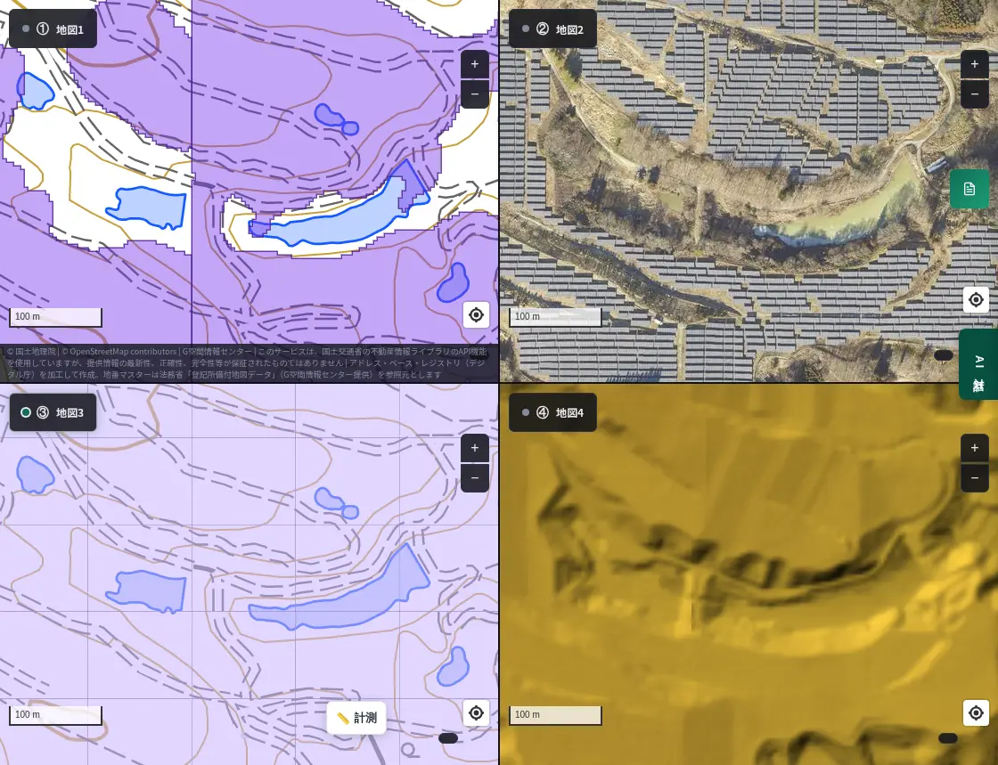
In the aerial photo at top right, a narrow stretch of water runs along the valley, with panels packed on both sides. The land use mesh at bottom left shows almost the whole area in the golf course color (light purple). The color elevation map at bottom right shows that the panels sit on undulating ground on both sides of the valley.
2. Fujioka, Gunma ― On top of band-like fairways
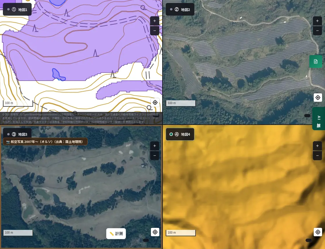
In the 2007 aerial photo at bottom left, bright fairways run like bands between stretches of trees. In today's aerial photo at top right, the panels line up along those bands. Some of the trees that separated the holes remain, visible here and there between the rows of panels.
3. Hodatsushimizu, Ishikawa ― Neat rows on nearly flat land
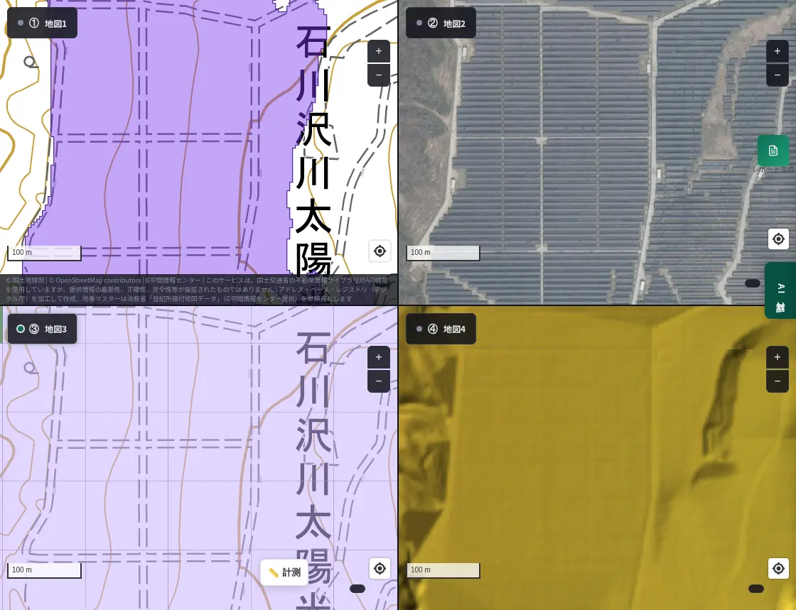
The aerial photo shows panels in the same direction, neatly arranged across the whole frame. The color elevation map at bottom right is almost uniform in color, showing gentle land with little relief. In the land use mesh, the whole area is classified as golf course.
4. Shimoda, Shizuoka ― Band-shaped panels along slopes
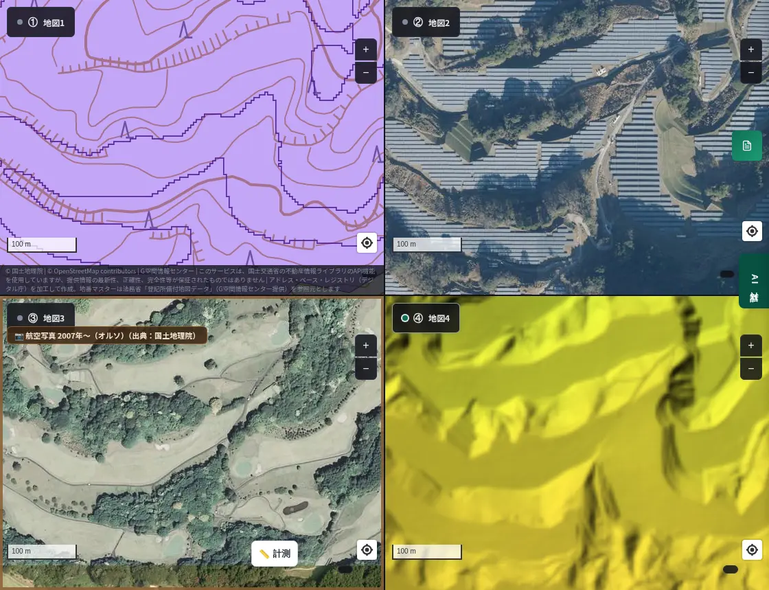
In the 2007 aerial photo, fairways curve through the trees on undulating land. In today's aerial photo, similar bands seem to have been replaced by panels. The color elevation map at bottom right clearly shows the stepped slopes.
5. Inabe, Mie ― A former course surrounded by forest
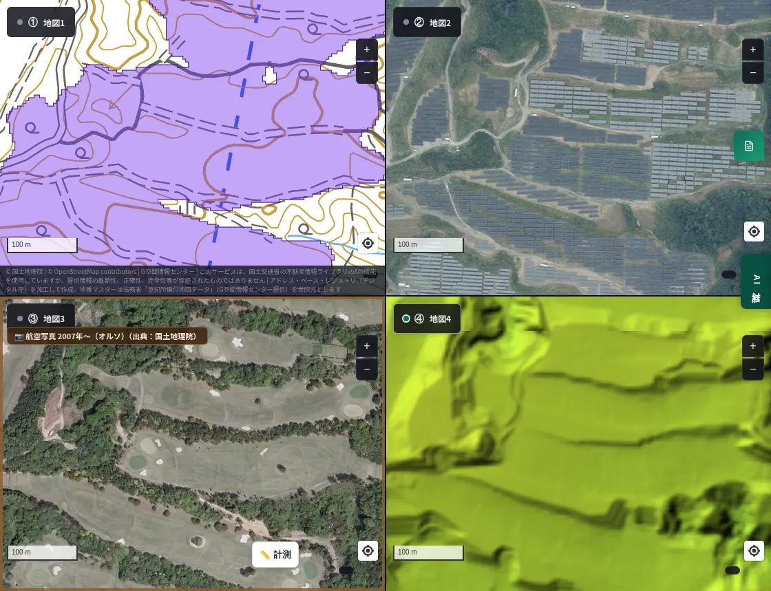
In the 2007 aerial photo at bottom left, white bunkers and green fairways stretch between stretches of trees. In today's aerial photo at top right, panels spread together in the middle of the forest. I think this is a very clear example, because you can compare the same place across time.
6. Mitoyo, Kagawa ― Traces of the course still remain in part
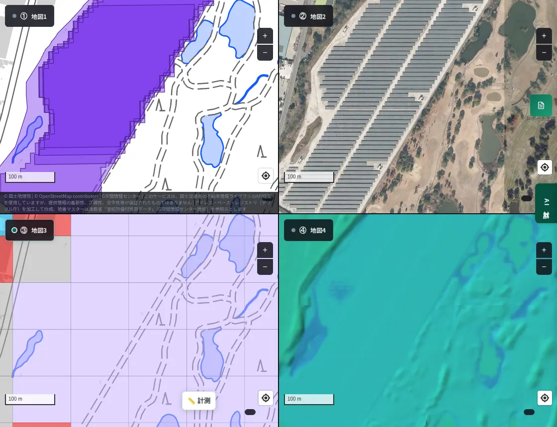
In the aerial photo at top right, to the right of the block of panels you can still see traces of the course, such as greens, bunkers and a pond. You can see the converted part and the remaining part side by side. The color elevation map at bottom right shows flat land with little relief.
7. Oita, Oita ― Regular rows across a wide area
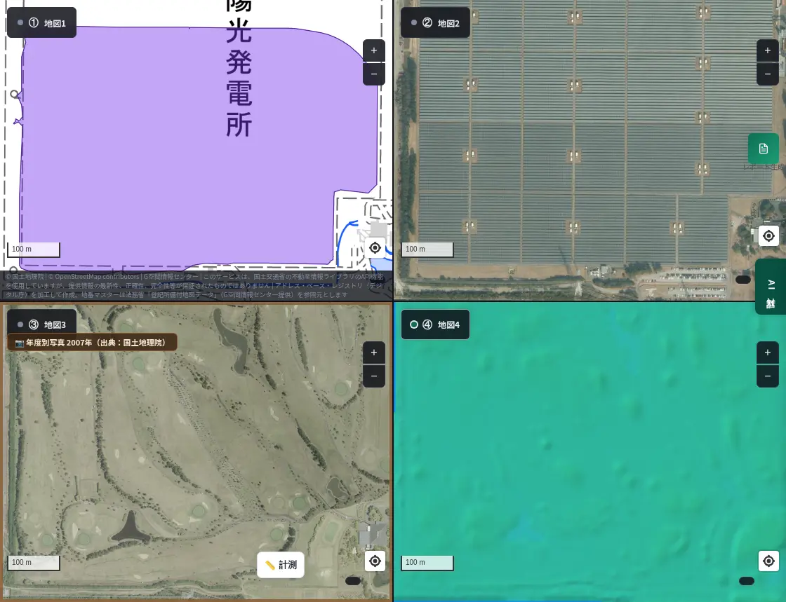
In the 2007 aerial photo at bottom left, the typical features of a golf course are clear: ponds, bunkers and curving fairways. In today's aerial photo at top right, panels are lined up regularly across the same area, with small equipment huts here and there. The color elevation map at bottom right shows almost flat land.
What Came Into View
Looking at the seven places, here is what I felt:
- Many sites are flat: Courses are shaped when they are built, so there are many fairly gentle areas, which may have made it easier to line up panels. Still, some places, such as Shimoda and Fujioka, have undulating land.
- The shape of the course seems to influence the panel layout: In several places, panels follow the bands of fairways or the blocks once divided by trees.
- Uses of former courses vary: In places like Mitoyo, part of the course still remains, so not every former course has been used in the same way.
Using land that people have already shaped, rather than clearing new forest, may be one option. On the other hand, for former courses on slopes, I would like to keep in mind how water flows and how soil moves when it rains. It may be easier to understand if you look at this together with the cliff-collapse warning zone layer introduced in an earlier article.
Golf and the Changing Times
Golf used to be one of Japan's big industries, as a place for socializing among office workers and as entertainment. Even now it takes up a large share of leisure activities. Even so, the number of people who play may have been decreasing since the peak.
On the map, fairways that many people once walked are now land with a different role. Aerial photos and land use records let us read this change of times.
Why Check on a Map?
In MAPRISE's 4-panel view, you can place panel detection, today's aerial photo, a past aerial photo and a color elevation map side by side for the same place. If a place interests you, such as your hometown, a travel destination, or a site for real estate, you can check it in the same way. The 4-panel view is available on the Starter plan and above.
About the Data and Sources
- Panel areas are estimated by AI and may not match the actual position of the panels.
- Whether a place "was a golf course" is judged from the National Land Numerical Information land use mesh (the 2006 edition, and the 1997 edition in some places) and past aerial photos from the Geospatial Information Authority of Japan. The mesh is coarse and old, so it may differ from the actual extent of a former course.
- The numbers of golf courses and golf participants are private surveys and press-reported figures that I could confirm at the time of writing (October 2026). Figures differ depending on who counts and how.
- This article introduces how to read the map and the information I found. It is not an evaluation of any particular course or operator. My views are personal opinions.
Questions and comments are welcome at info@maprise.jp.
Sources
- 2024/9/9 Operating golf courses down 12 from last year to 2,121 (Ikki Publishing)
- 2025/8/7 Operating golf courses down 11 from last year to 2,110 (Ikki Publishing)
- The latest number of golf courses in Japan is "2,123" (e-GOLF)
- Golf courses turning into solar power plants across Japan (Smart Japan)
- 100,000 solar panels on a former golf course (Smart Japan)
- Why golf courses are in trouble after the end of the mega solar bubble (Diamond Online)
- Leisure White Paper (Japan Productivity Center)
- Maps and data: National Land Numerical Information, land use mesh (MLIT); GSI Tiles (year-by-year aerial photos, color elevation map), Geospatial Information Authority of Japan (processed and displayed in MAPRISE; providers and licenses are listed on our Data sources page, and the data you can view on the map on our Layer catalogue)
Tags: #golf courses #solar power #mega solar #land use #aerial photos #color elevation map #4-panel view
Other-language share text (exception cases)
Quick share above follows our platform-locked language policy (X-family in Japanese, LinkedIn in English). The four panes below let you grab the opposite-language body when needed — e.g. introducing an English post to a Japanese audience on X, or posting a Japanese article to LinkedIn in Japanese. Each pane offers both a copy button and a direct intent link.
📝 ゴルフ場の跡地に広がる太陽光パネル ― 閉場したコースの数と、全国7か所を4分割で見る
ゴルフ場の数は、最も多かった頃と比べて約1割減りました。その跡地に太陽光パネルが並ぶ場所を、全国7か所で、AIのパネル検知・現在の航空写真・過去の航空写真(または過去の土地利用)・色別標高図の4分割で見比べました。
https://maprise.jp/ja/blog/solar-panels-golf-courses/ #ゴルフ場 #太陽光発電
🆕 新しいブログ記事を公開しました。

《ゴルフ場の跡地に広がる太陽光パネル ― 閉場したコースの数と、全国7か所を4分割で見る》

ゴルフ場の数は、最も多かった頃と比べて約1割減りました。その跡地に太陽光パネルが並ぶ場所を、全国7か所で、AIのパネル検知・現在の航空写真・過去の航空写真(または過去の土地利用)・色別標高図の4分割で見比べました。

👉 詳しくはこちら: https://maprise.jp/ja/blog/solar-panels-golf-courses/
📝 Solar Panels on Former Golf Courses ― How Many Have Closed, and Seven Places in Japan in a 4-Panel View
The number of golf courses in Japan is about 10% below its peak. We looked at seven former courses across the country wh…
https://maprise.jp/en/blog/solar-panels-golf-courses/ #golfcourses #solarpower
🆕 New on the MAPRISE blog.

《Solar Panels on Former Golf Courses ― How Many Have Closed, and Seven Places in Japan in a 4-Panel View》

The number of golf courses in Japan is about 10% below its peak. We looked at seven former courses across the country where solar panels now cover the land, using MAPRISE's 4-panel view: AI panel detection, today's aerial photo, a past aerial photo (or past land use), and a color elevation map.

👉 Read the full post: https://maprise.jp/en/blog/solar-panels-golf-courses/

#golfcourses #solarpower #megasolar #landuse #aerialphotos
Related posts
- Solar Panels and the Future of Mountain Forests ― Kansai and Chukyo in a 4-Panel View, and Thoughts on Lifespan, Policy and Forests2026-10-03
- Don't Choose a Cliff-Top Home on View and Elevation Alone: Retaining Walls, Disclosure Rules, Land Prices and Yellow Zones, City by City (Part 2)2026-10-25
- Did the Rich Move Uphill to Avoid Floods? Testing 'Yamanote vs Shitamachi' in Tokyo, Nagoya, Osaka and Fukuoka with Four Maps2026-10-24