Calderas are the huge depressions left by giant eruptions. Using MAPRISE's split view, we placed a black-and-white hillshade next to an elevation map colored by height. The outlines of Aso, Lake Toya, Lake Shikotsu, Lake Towada, Lake Kussharo, Lake Mashu and Hakone stand out in both.
Hello, this is the MAPRISE development team. This time we look at calderas, a popular travel destination, using MAPRISE's split view.
Put a black-and-white hillshade (a map that draws relief with light and shadow) beside a colored elevation map (a map that paints each height band in its own color, like contour lines filled in), and the shape of the land becomes much easier to read. Calderas, being huge depressions, are an ideal subject for comparing the two.
What is a caldera?
A caldera is a large depression formed by volcanic activity. The word comes from the Spanish for "cauldron."
When a large eruption empties the magma chamber, the ground above can collapse, leaving a hollow several to tens of kilometers across. If water fills it, it becomes a caldera lake such as Lake Toya or Lake Shikotsu. In some places, like Aso, towns and farmland spread across the floor.
The most recent caldera-forming eruption in Japan is considered to be the Kikai caldera eruption (south of Kyushu) about 7,300 years ago.
What the split view shows
The split view places two maps side by side at the same position and scale.
- Left: black-and-white hillshade. Ridges and valleys appear as light and shade, as if lit from an angle. The rim and the small peaks inside look three-dimensional.
- Right: colored elevation. Color changes step by step from low to high, showing the height difference between floor and rim, and the extent of flat ground.
In our view, the hillshade shows shape and the colored elevation shows height. Side by side, each covers the other's weakness.
Aso caldera (Kumamoto)
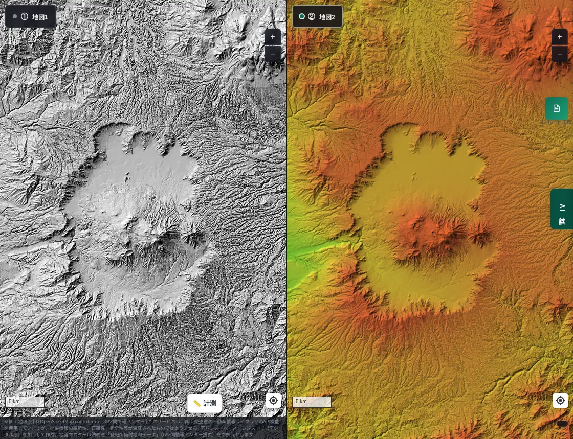
Aso measures about 18 km east–west and 25 km north–south, one of the largest calderas in the world. Four giant eruptions occurred between roughly 270,000 and 90,000 years ago, the last being the largest.
The hillshade shows the surrounding rim and the central cones clearly. The colored elevation shows the low, flat ground inside the rim, where towns and fields are located.
Lake Toya (Hokkaido)
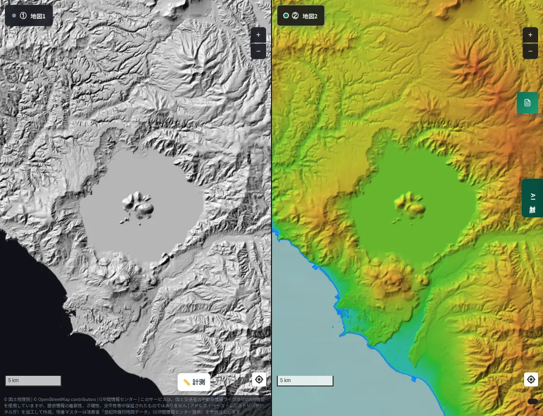
Lake Toya fills a caldera said to have formed about 110,000 years ago. It is nearly circular, about 10 km across, with an island in the center and the still-active Mt. Usu to the south.
In the colored elevation, the rim forms a neat ring around the lake. In the hillshade, the rugged ground around Mt. Usu and Showa-Shinzan stands out.
Lake Shikotsu (Hokkaido)
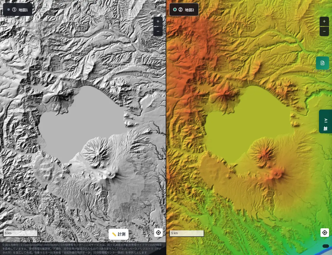
Lake Shikotsu fills a caldera formed by a giant eruption about 40,000 years ago, roughly 12 km across. It is deep, about 360 m at most, and known for rarely freezing in winter.
Younger volcanoes such as Mt. Fuppushi and Mt. Tarumae stand on the south side. The hillshade lets you read the story of new volcanoes growing along the rim of a great hollow.
Lake Towada (Aomori / Akita)
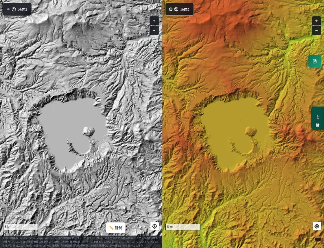
Lake Towada fills a caldera formed through several eruptions. The surface lies at about 400 m, and the maximum depth is about 327 m, among the deepest in Japan.
The two peninsulas jutting into the lake (Nakayama and Okura) are clear in the hillshade, while the ring of mountains around it reads better in the colored elevation.
Lake Kussharo (Hokkaido)
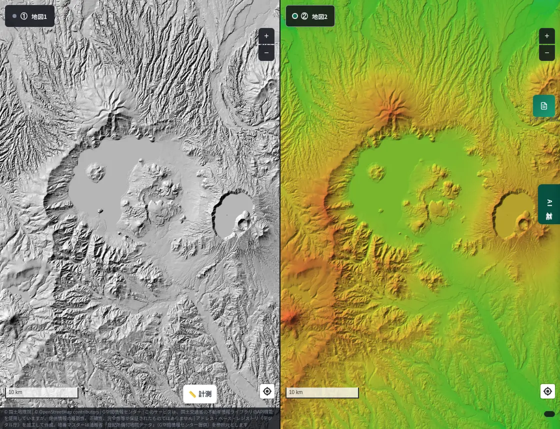
The Kussharo caldera measures about 26 km east–west and 20 km north–south, among the largest in Japan. About half of the depression is Lake Kussharo, with an island near its center.
It is so large that standing inside it, you can hardly tell. Zoomed out in the split view, its size and rim are obvious at a glance. The Mashu caldera overlaps it on the inside.
Lake Mashu (Hokkaido)
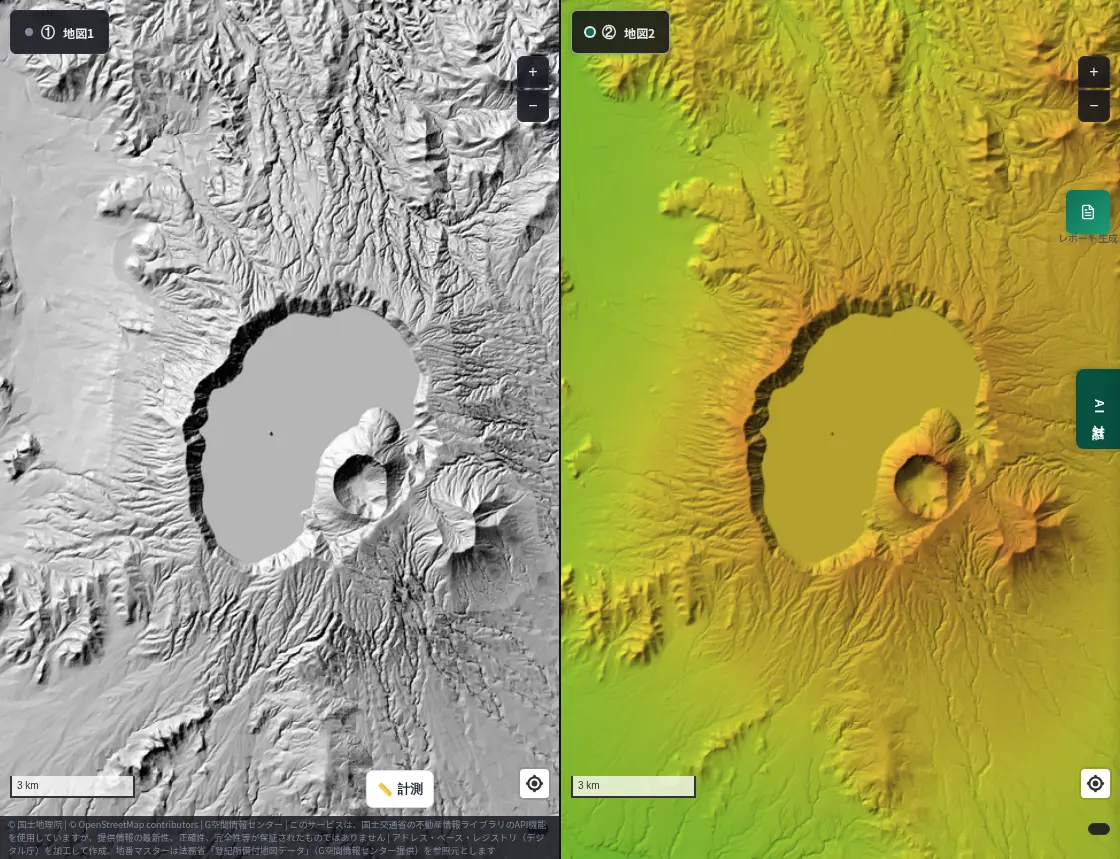
Lake Mashu fills another caldera nested inside the Kussharo caldera. Steep walls surround it, and with no river flowing in or out, it is known for its exceptional clarity.
In the hillshade the steepness of the walls shows as dark bands of shadow. In the colored elevation, the drop from the rim to the water is visible as a change of color. The famous "Mashu Blue" lake sits at the bottom of a deep bowl.
Hakone (Kanagawa / Shizuoka)
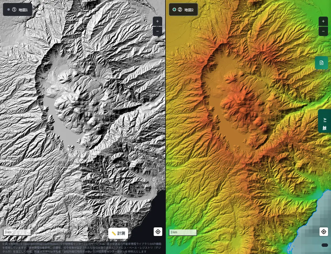
Hakone, popular for its hot springs and Lake Ashi, actually sits on caldera terrain enclosed by an outer rim, with central cones such as Mt. Kami and Mt. Komagatake inside.
Close to the Tokyo area and visited by many, it reveals its origin in the hillshade: mountains and a lake within a hollow. It is described as several smaller calderas joined by erosion, and the colored elevation makes the height of its intricate rim easy to follow.
Next time you travel, remember MAPRISE
Calderas offer lakes, hot springs, viewpoints and scenic drives, and many people visit them. When you go, we would be glad if you remembered MAPRISE.
- Before you go. Check the shape and height of your destination in the split view to see the scenery differently.
- Choosing viewpoints. Find high rim spots in the colored elevation, and open directions in the hillshade.
- After you return. Look back on your trip on the map: "so that lake sat in a hollow like this."
An eye for terrain also carries over to land research. MAPRISE is a map service for real-estate site evaluation and due diligence, and we hope the fun of reading terrain on a trip helps in your work too.
About the data
- The hillshade and colored elevation maps are GSI Tiles based on the Geospatial Information Authority of Japan's elevation data.
- Caldera sizes and ages are approximate and vary by study.
- This article introduces how terrain looks; it is not a substitute for volcano or disaster-prevention information. Please check the latest information from the Japan Meteorological Agency and local governments.
Closing
Change the way you look at a map, and the same land shows a different face. Next time you head to a caldera or volcano, try the split view.
Questions or feedback are welcome at info@maprise.jp.
Sources
- Caldera (Wikipedia, Japanese)
- Maps and data: GSI Tiles (hillshade and colored elevation) (processed and displayed in MAPRISE; providers and licenses are listed on our Data sources page, and the data you can view on the map on our Layer catalogue)
Tags: #Lake Mashu #Hakone #caldera #hillshade #elevation #Aso #Lake Toya #Lake Shikotsu #Lake Towada #Lake Kussharo #split view #terrain
Other-language share text (exception cases)
Quick share above follows our platform-locked language policy (X-family in Japanese, LinkedIn in English). The four panes below let you grab the opposite-language body when needed — e.g. introducing an English post to a Japanese audience on X, or posting a Japanese article to LinkedIn in Japanese. Each pane offers both a copy button and a direct intent link.
📝 日本のカルデラを白黒の陰影図と色別標高図で見比べる ― 阿蘇・摩周湖・洞爺湖・箱根ほか
巨大噴火が残した大きな凹地「カルデラ」を、MAPRISEの2分割表示で、白黒の陰影起伏図と、標高ごとに色分けした色別標高図に並べてみました。阿蘇、洞爺湖、支笏湖、十和田湖、屈斜路湖、摩周湖、箱根の輪郭が、2つの見え方でくっきり浮かび上がります。
https://maprise.jp/ja/blog/caldera-hillshade-contour/ #摩周湖 #箱根
🆕 新しいブログ記事を公開しました。

《日本のカルデラを白黒の陰影図と色別標高図で見比べる ― 阿蘇・摩周湖・洞爺湖・箱根ほか》

巨大噴火が残した大きな凹地「カルデラ」を、MAPRISEの2分割表示で、白黒の陰影起伏図と、標高ごとに色分けした色別標高図に並べてみました。阿蘇、洞爺湖、支笏湖、十和田湖、屈斜路湖、摩周湖、箱根の輪郭が、2つの見え方でくっきり浮かび上がります。

👉 詳しくはこちら: https://maprise.jp/ja/blog/caldera-hillshade-contour/
📝 Japan's Calderas in Black-and-White Hillshade and Colored Elevation ― Aso, Mashu, Toya, Hakone and More
Calderas are the huge depressions left by giant eruptions. Using MAPRISE's split view, we placed a black-and-white hillshade n…
https://maprise.jp/en/blog/caldera-hillshade-contour/ #LakeMashu #Hakone
🆕 New on the MAPRISE blog.

《Japan's Calderas in Black-and-White Hillshade and Colored Elevation ― Aso, Mashu, Toya, Hakone and More》

Calderas are the huge depressions left by giant eruptions. Using MAPRISE's split view, we placed a black-and-white hillshade next to an elevation map colored by height. The outlines of Aso, Lake Toya, Lake Shikotsu, Lake Towada, Lake Kussharo, Lake Mashu and Hakone stand out in both.

👉 Read the full post: https://maprise.jp/en/blog/caldera-hillshade-contour/

#LakeMashu #Hakone #caldera #hillshade #elevation
Related posts
- Solar Panels on Slopes and Cliff-Collapse Warning Zones in a 4-Panel View ― Places to Watch in Heavy Rain2026-10-03
- Closed Lines Have Histories Too — Tracing Coal, Factory and Streetcar Lines on a Four-Panel Map2026-10-15
- You don't need to memorize 50+ layers — one-click Purpose Presets turn on exactly what you need2026-07-26