A river whose bed has risen above the surrounding town after repeated levee raising is called a tenjogawa, or "ceiling river." We compare elevation maps and the national flood inundation forecast for the Ashiya and Sumiyoshi rivers near Osaka and Kobe, the former Kusatsu River in Shiga, the Shonai River in Nagoya, and Tokyo's Arakawa, as a starting point for thinking about disaster prevention.
Hello, this is the MAPRISE development team.
We tend to think that a river flows at the lowest point. Yet in Japan there are rivers whose beds lie higher than the ground of the surrounding town. They are called "tenjogawa," or ceiling rivers. When a levee fails or water overflows, it flows toward the town. And once water has collected in the town, it has trouble returning to the river.
In this article we look at examples near large metropolitan areas — Osaka and Kobe, Shiga near Kyoto, Nagoya, and Tokyo — using the MAPRISE map. We check the relationship between river and town with elevation maps, and read them together with the national flood inundation forecast as a starting point for disaster prevention.
How does a ceiling river form?
A ceiling river is a river whose bed has risen above the surrounding plain through the deposit of sand and gravel. The mechanism is explained as follows.
- Levees are built to prevent floods.
- Once the levees fix where the water flows, the sediment carried by the river keeps settling in the same place.
- As the riverbed rises, flooding becomes a concern, so the levees are raised again.
- Repeating this leaves the riverbed higher than the surrounding town.
It is said to happen easily in rivers that carry a lot of sediment, such as those with easily weathered granite mountains upstream. According to Wikipedia, as of 2014 there were at least 240 ceiling rivers in 29 prefectures, with 122 in the Kansai region and 81 in Shiga Prefecture alone.
A note on terminology
The definition of "ceiling river" varies. Geomorphological explanations often limit it to relatively small rivers formed on alluvial fans and at their toes. Large rivers on broad plains, such as the Shonai River in Nagoya, are classified as ceiling rivers, but some sources treat them separately from fan-type ceiling rivers. Tokyo's Arakawa is not generally called a ceiling river.
In this article we separate ceiling rivers on fans (Hanshin and Shiga) from rivers on broad plains where levees can make the water level higher than the ground of the town (Nagoya and Tokyo). For life in a large metropolitan area, both carry the same concern: the river's water level can rise above the town's ground.
The elevation figures in this article are approximate values calculated from cross-sections taken within the MAPRISE map area, using the Geospatial Information Authority of Japan's 5 m mesh elevation. A levee crest is narrow, so figures may differ from the actual height by several meters, and they change with where the section is taken.
1. Osaka and Kobe — the Ashiya and Sumiyoshi rivers
On the south side of Mount Rokko in the Hanshin area, ceiling rivers line up: the Ashiya, Sumiyoshi, Ishiya, and Shukugawa. The JR Tokaido Line passes through tunnels beneath the riverbeds. The Ishiya River tunnel, completed in 1871, is regarded as Japan's first railway tunnel (it no longer exists after the line was elevated). The riverbed tunnels under the Sumiyoshi and Ashiya rivers are said to be still in use.
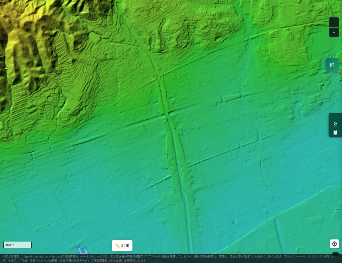
First, the area around the Ashiya River on the MAPRISE color-coded elevation map. Blue-green is low; yellow-green to yellow is high.
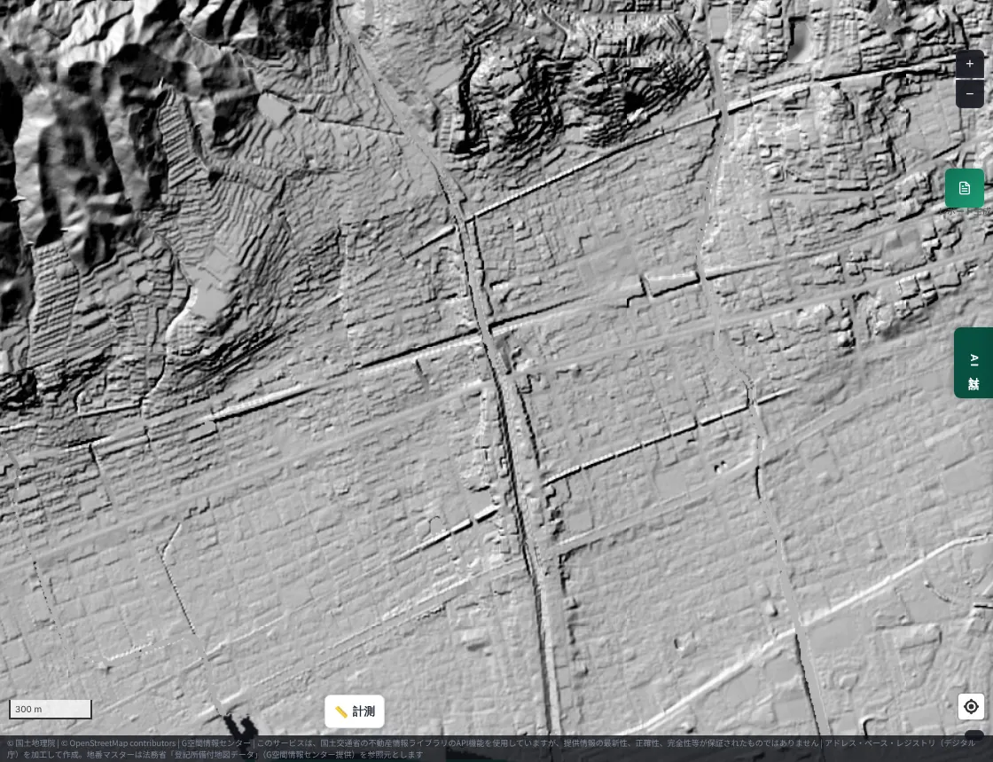
Next, the same place as a black-and-white hillshade, which draws relief with light and shadow. The river line rises like a long, thin ridge within the town.
The Sumiyoshi River (Higashinada Ward, Kobe) looks similar.
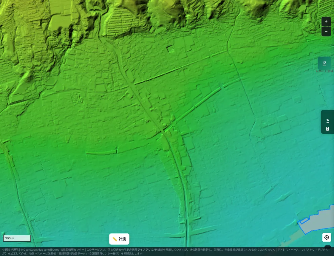
Measured on a cross-section, on the Ashiya River the surrounding ground was about 2 m, the river's center about 3 m, and the levee crest about 6 m. On the Sumiyoshi River the surrounding ground was about 13 m, the center about 15 m, and the levee crest about 21 m (in this section). The center of the channel, where the water flows, is already higher than the surrounding town.
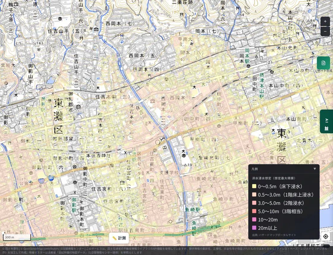
Next, the national flood inundation forecast. MAPRISE displays data from the Ministry of Land, Infrastructure, Transport and Tourism's Hazard Map Portal Site. First, the maximum scale (the largest rainfall that can be assumed).
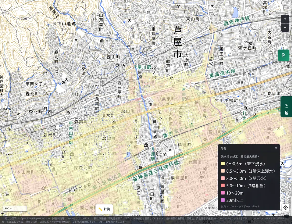
The picture changes when the planned scale (the rainfall river improvement is designed for) is shown for the same place.
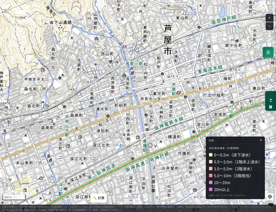
At the planned scale almost no forecast color appears; at the maximum scale color appears across a wide part of the urban area. One reading is that the river may not overflow in the rain it was designed for, but in heavier rain, wide flooding can occur inside the levees. (On this screen, the absence of color does not mean safety.)
Around the Sumiyoshi River, the maximum scale likewise shows forecast color across the urban area near the river mouth.
2. Shiga, near Kyoto and Osaka — the former Kusatsu River
Shiga is the prefecture said to have the most ceiling rivers in Japan. In Kusatsu City, just east of Otsu, there was once a typical ceiling river, the Kusatsu River. The JR Tokaido Line (Biwako Line) passed beneath the riverbed. In 2002 a new diversion channel was completed and the ceiling-river section was abolished.
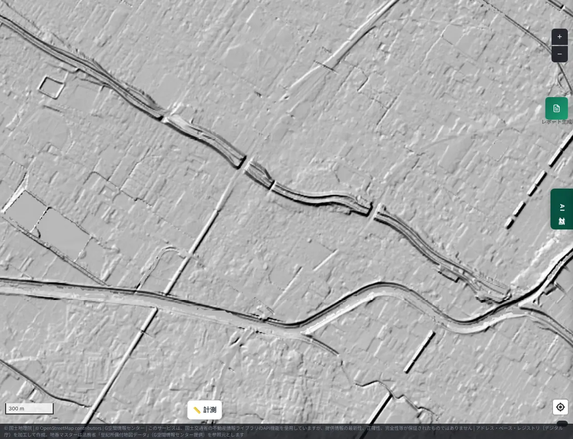
Its remains, on a hillshade: the old river survives as a long, raised bank in the middle of farmland.
On the color-coded elevation map, this line shows up within the flat land.
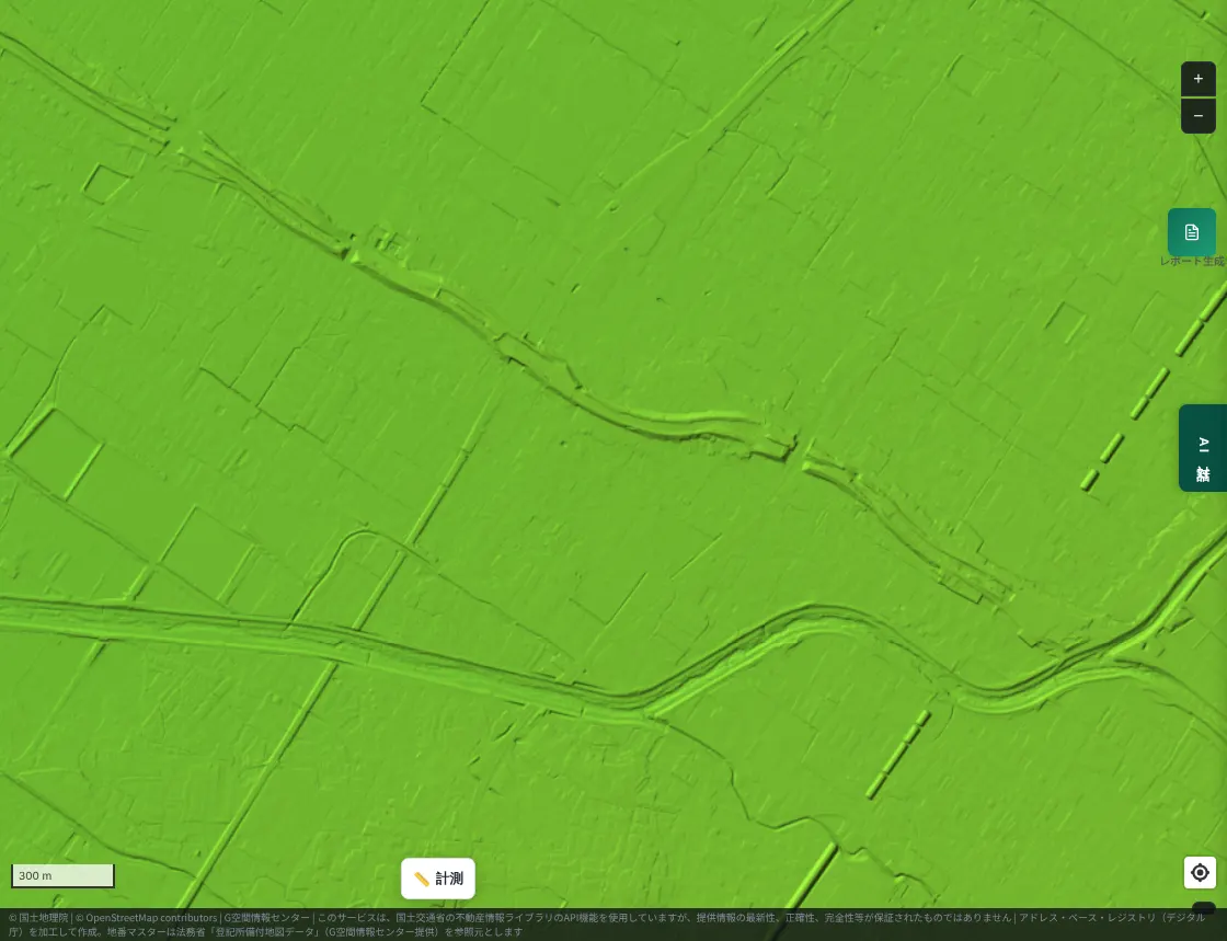
Measured on a cross-section, where the surrounding ground was about 94 m, the old riverbed was about 101 m and the crest of the old levee about 104 m. An embankment about 7 m to 10 m above the surrounding ground still remains. Another source says that when it was a ceiling river, it flowed 5 to 6 m above the surrounding land near the center of Kusatsu. Figures differ depending on where they are measured.
In the flood inundation forecast (maximum scale), a color for below-floor flooding (under 0.5 m) spreads across a wide part of the Kusatsu plain.
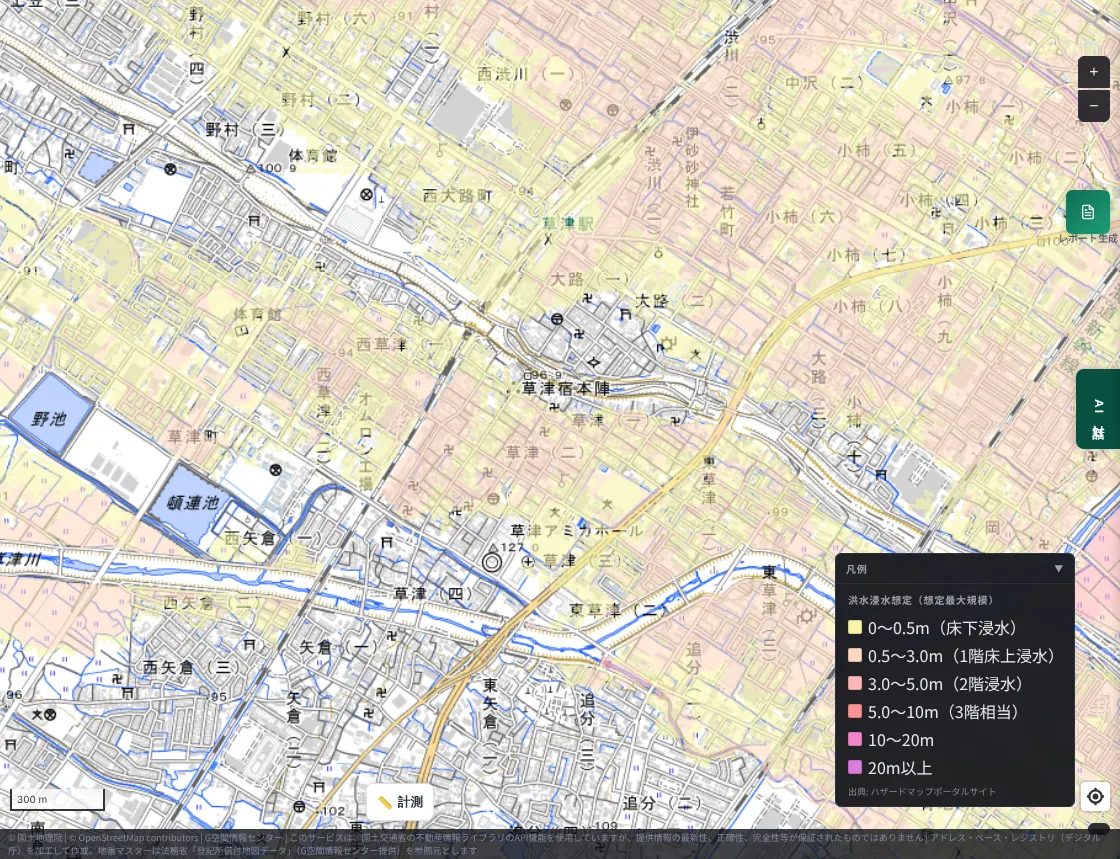
The abolished former Kusatsu River no longer carries floodwater. Because the embankment remains as landform, however, it is still a clue to the heights of the surrounding land.
3. Nagoya — the Shonai and Yada rivers
The Shonai River, flowing through northern Nagoya, is described in a Ministry of Land, Infrastructure, Transport and Tourism document as "the middle and lower reaches are low flat land and a ceiling river, a terrain prone to flood damage." In the lower Shonai, the reclamation of land near the river mouth is said to have lengthened the channel and slowed the flow, so the riverbed gradually rose and floods became frequent. In 1784 (Tenmei 4), flood-control works, including the excavation of the Shinkawa channel (the "Tenmei flood control"), were carried out to reduce flood damage.
As noted above, some sources treat the Shonai separately from fan-type ceiling rivers; it is a large river on a broad plain, where levees can make the water level higher than the ground of the town. We did not measure cross-section elevations in Nagoya this time. Here is the color-coded elevation map of the Shonai River and its tributary, the Yada River (around Moriyama Ward, Nagoya).
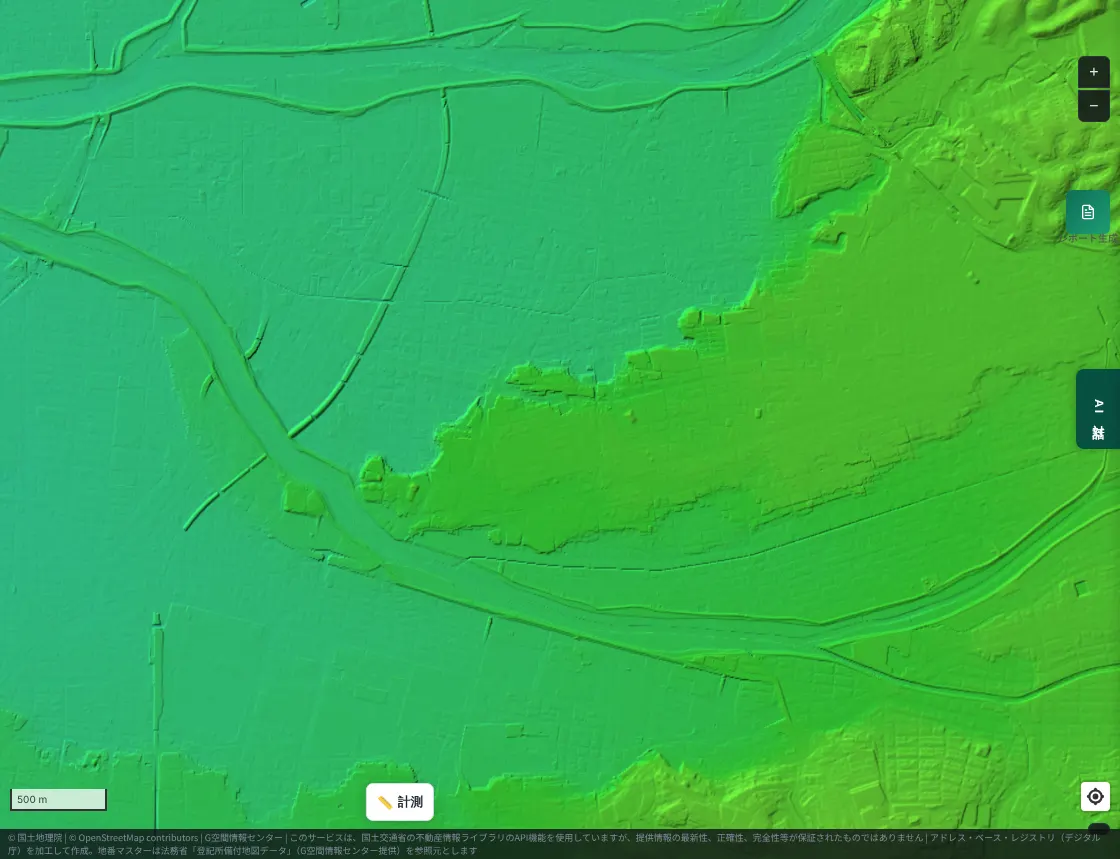
Next, the flood inundation forecast (maximum scale).
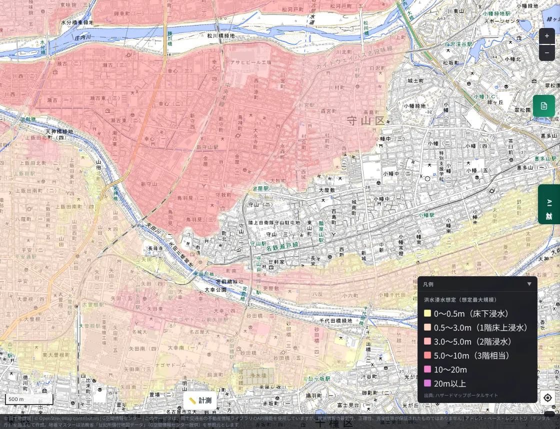
A wide part of the lowland around the Shonai and Yada rivers is covered in a dark color for flood depth of 3 m or more. On the plateau to the east there is almost no color. The map shows that the forecast differs greatly with the height of the land, not just the distance from the river.
4. Tokyo — the Arakawa (Katsushika and Adachi wards)
In this survey we could not confirm a typical fan-type ceiling river in Tokyo, and the Arakawa is not generally called a ceiling river. Even so, in eastern Tokyo there are places where the river's water level can rise above the ground of the town. One is the lower Arakawa.
The "Koto 5 wards" — Sumida, Koto, Adachi, Katsushika, and Edogawa — have most of their area at or below the high-tide level (the sea surface at high tide). It could also be put as land protected by levees.
Here is the area around the Arakawa on the color-coded elevation map. Blue-green is low; blue is lower still.
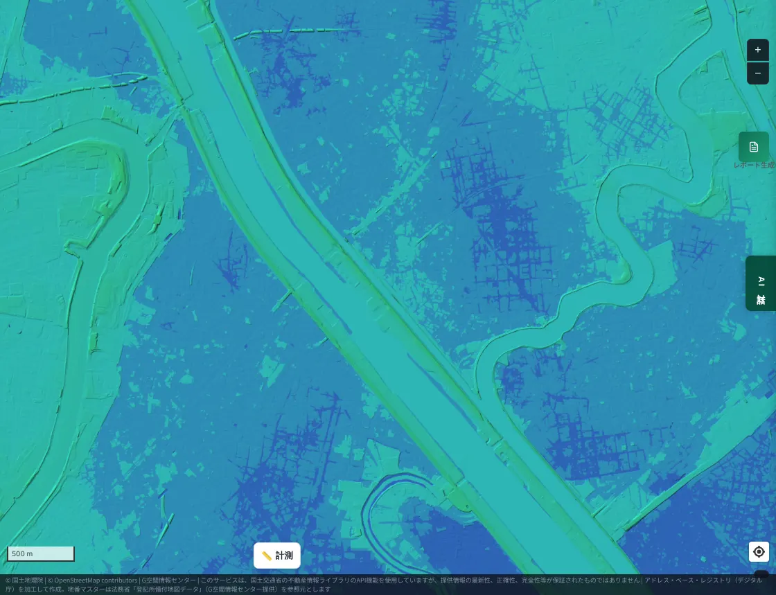
Measured on a cross-section, the urban areas on both sides of the river were at about minus 0.5 m — below sea level. The Arakawa's levee crest reaches about 8 m at most. If water goes over or through the levee, it flows toward the town.
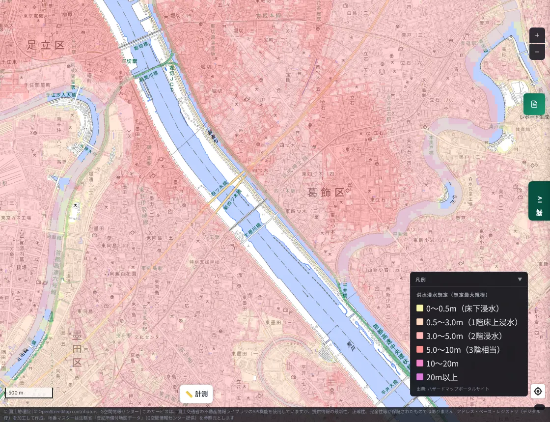
In the flood inundation forecast (maximum scale), a color for flood depth of 3 m or more spreads across a wide area along the Arakawa.
At the planned scale, color also appears widely across the same area.
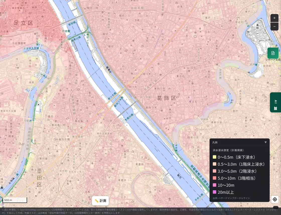
Unlike places in Hanshin where almost no color appears at the planned scale, along the Arakawa the forecast is for wide flooding even in more frequent heavy rain. The Koto 5 wards have drawn up a wide-area evacuation plan assuming a large-scale flood in which an Arakawa flood coincides with a Tokyo Bay storm surge. According to Edogawa Ward's materials, the five wards aim to start joint consideration about 3 days (72 hours) before the flood and issue wide-area evacuation information about 1 day before.
The numbers, side by side
We gathered the elevations measured on the cross-sections into one figure. Brown is the ground, the red dashed line is the levee crest, and the green dashed line is the ground of the surrounding town.
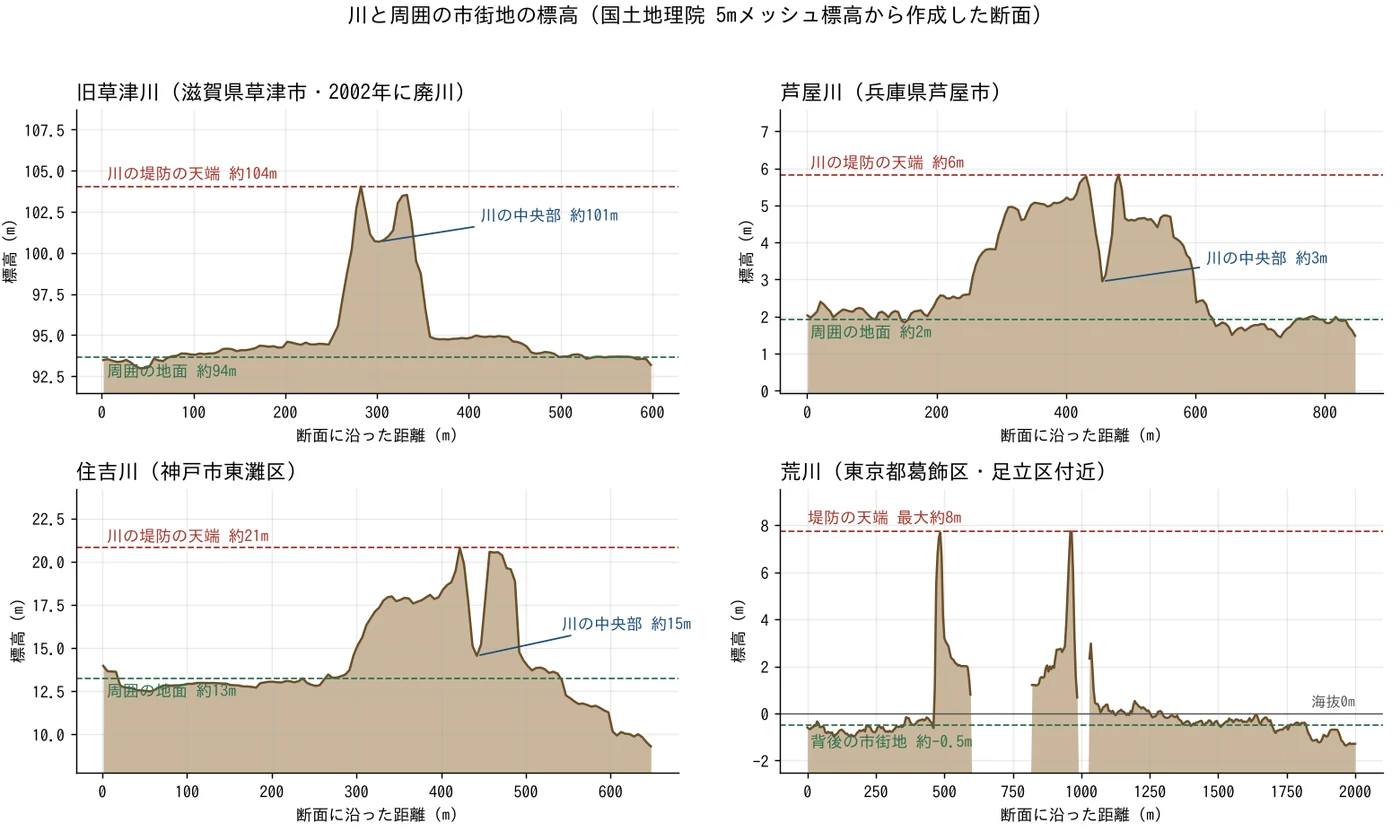
| River | Surrounding ground | Center of the river | Levee crest |
|---|---|---|---|
| Ashiya River (Ashiya, Hyogo) | about 2 m | about 3 m | about 6 m |
| Sumiyoshi River (Higashinada Ward, Kobe) | about 13 m | about 15 m | about 21 m |
| Former Kusatsu River (Kusatsu, Shiga) | about 94 m | about 101 m | about 104 m |
| Arakawa (around Katsushika and Adachi wards, Tokyo) | about minus 0.5 m | not measurable (water surface) | about 8 m at most |
The center of the Arakawa could not be measured because the elevation data does not include the water surface.
What happens when the water overflows?
For ceiling rivers and rivers whose levees protect lower ground, the following are concerns.
- Water pours out toward the town all at once. When a levee breaks, the river's high water level flows straight into the town.
- Water drains slowly and damage lasts. Water collected on land lower than the river has difficulty returning to it (according to Kashiwara City's materials). In the recent Chiba flooding (the Lake Inba levee breaches), some areas were still flooded two weeks after the event. See also our comparison of the Chiba flooded areas and MAPRISE map layers.
- Tributary water can no longer be released into the main river. During the 2019 Typhoon Hagibis, the Chikuma River's water level rose in Nagano, and it was reported that water from the Asakawa, a tributary about 7 m below the Chikuma's levee, could not flow into the Chikuma, causing inland flooding (Shinano Mainichi Shimbun).
How to check your surroundings on a map
- Look at the line of a nearby river on a color-coded elevation map or hillshade. If the river looks like a long, thin ridge within the town, the river's water level may be higher than the ground of the town.
- Look at both the maximum scale and the planned scale of the flood inundation forecast. Some places show no color at the planned scale but wide color at the maximum scale.
- Do not feel safe just because no forecast color appears. Flood inundation forecasts are made for rivers designated by the national or prefectural government. Small rivers and forecasts for inland flooding may not appear on this map.
- Be sure to check your municipality's hazard map. For evacuation places and routes, the information your municipality provides is the basis.
Other ceiling rivers around Japan
Besides those above, the following ceiling rivers are known. Please check the materials of each river administrator for individual conditions.
- Tama River (Ide Town, Kyoto): a ceiling river that flows over the tunnel of the JR Nara Line. The southern Kyoto Basin is said to have several ceiling-river tunnels on the JR Nara Line and others.
- Yamato River (Osaka): said to have been a ceiling river before it was rerouted (Kashiwara City's materials).
- Shirakawa (Kumamoto City): regarded as a ceiling river. In the flood of June 26, 1953, Kumamoto's urban area was hit, and a Ministry of Land, Infrastructure, Transport and Tourism document records 422 dead or missing and 31,145 flooded houses.
- Asakawa (Nagano City): according to Nagano Prefecture materials, river improvement including the elimination of the ceiling river was completed in 2016, and the Asakawa Dam by 2017.
Limitations, stated honestly
- Elevation figures are approximate values from cross-sections of the Geospatial Information Authority of Japan's 5 m mesh elevation. A levee crest is narrow, and figures may differ from the actual height by several meters.
- The definition of "ceiling river" varies. The Shonai River is described as a "ceiling river" in a Ministry of Land, Infrastructure, Transport and Tourism document, but some sources treat it separately from fan-type ceiling rivers. The Arakawa is not generally called a ceiling river; this article introduces it as an example where the town behind a levee can lie below the river's water level.
- We did not measure cross-section elevations in Nagoya. The description of the Shonai as a "ceiling river" is based on the Ministry's document.
- The flood inundation forecast is based on data from the Ministry of Land, Infrastructure, Transport and Tourism's Hazard Map Portal Site and is a forecast under assumed conditions such as the pattern of rainfall. Please check the latest information in publications of your local government and the Ministry.
- In Tokyo, we could not confirm a typical fan-type ceiling river in this survey. That does not mean none exists.
- This article introduces general information. It does not guarantee the safety of any individual site.
Closing
The assumption that "a river flows at the lowest point" wavers a little once you know about ceiling rivers. We hope you will take a moment to look at the relationship between the rivers near your home or workplace and the height of the town on a map.
Questions and comments are welcome at info@maprise.jp.
Sources
- Tenjogawa (Wikipedia)
- Geomorphology terms: Raised bed river
- Ceiling rivers and floods (Kashiwara City)
- A railway under a river? The ceiling river that the Tokaido Line passes through (Norimono News)
- Rivers of Japan — Chubu — Shonai River (Ministry of Land, Infrastructure, Transport and Tourism)
- Flood control in large cities (Shonai River, Ministry document)
- Koto 5 Wards Large-Scale Flood Council (Edogawa Ward)
- Koto 5 Wards wide-area evacuation plan (Risk Management Navi)
- Levee breach: the Chikuma River pumps could not drain; inland flooding on the tributary Asakawa (Shinano Mainichi Shimbun)
- June 26, 1953 (Kyushu Regional Development Bureau, MLIT)
- Overview of the Asakawa basin and river (Nagano Prefecture)
- Maps and data: Elevation API and elevation tiles (Geospatial Information Authority of Japan) (processed and displayed in MAPRISE; providers and licenses are listed on our Data sources page, and the data you can view on the map on our Layer catalogue)
The maps in this article show MAPRISE's Color-coded Elevation Map and Hillshade (Geospatial Information Authority of Japan) and Flood Inundation Forecast (Maximum Scale and Planned Scale; Hazard Map Portal Site, Ministry of Land, Infrastructure, Transport and Tourism). Cross-section elevations are approximate values created from the Geospatial Information Authority of Japan's 5 m mesh elevation (DEM5A) and do not guarantee actual heights.
Tags: #Ceiling river #Tenjogawa #Flood inundation forecast #Hazard map #Elevation #Hillshade #Ashiya River #Sumiyoshi River #Arakawa #Shonai River #Disaster prevention
Other-language share text (exception cases)
Quick share above follows our platform-locked language policy (X-family in Japanese, LinkedIn in English). The four panes below let you grab the opposite-language body when needed — e.g. introducing an English post to a Japanese audience on X, or posting a Japanese article to LinkedIn in Japanese. Each pane offers both a copy button and a direct intent link.
📝 川の底が、街より高いところを流れている ― 天井川と、堤防の内側で暮らすということ(阪神間・滋賀・名古屋・東京の荒川)
堤防にかさ上げを重ねた結果、川の底が周囲の街より高くなった川を「天井川」と呼びます。大阪・神戸圏の芦屋川・住吉川、滋賀の旧草津川、名古屋の庄内川、東京の荒川を、標高図と国の洪水浸水想定で見比べ、防災を考える手がかりにします。
https://maprise.jp/ja/blog/tenjogawa-ceiling-rivers/ #天井川 #洪水浸水想定
🆕 新しいブログ記事を公開しました。

《川の底が、街より高いところを流れている ― 天井川と、堤防の内側で暮らすということ(阪神間・滋賀・名古屋・東京の荒川)》

堤防にかさ上げを重ねた結果、川の底が周囲の街より高くなった川を「天井川」と呼びます。大阪・神戸圏の芦屋川・住吉川、滋賀の旧草津川、名古屋の庄内川、東京の荒川を、標高図と国の洪水浸水想定で見比べ、防災を考える手がかりにします。

👉 詳しくはこちら: https://maprise.jp/ja/blog/tenjogawa-ceiling-rivers/
📝 Rivers That Flow Above the City — Ceiling Rivers (Tenjogawa) and Living Behind a Levee (Hanshin, Shiga, Nagoya, and Tokyo's Arakawa)
A river whose bed has risen above the surrounding town after repeated levee raising is call…
https://maprise.jp/en/blog/tenjogawa-ceiling-rivers/ #Ceilingriver #Tenjogawa
🆕 New on the MAPRISE blog.

《Rivers That Flow Above the City — Ceiling Rivers (Tenjogawa) and Living Behind a Levee (Hanshin, Shiga, Nagoya, and Tokyo's Arakawa)》

A river whose bed has risen above the surrounding town after repeated levee raising is called a tenjogawa, or "ceiling river." We compare elevation maps and the national flood inundation forecast for the Ashiya and Sumiyoshi rivers near Osaka and Kobe, the former Kusatsu River in Shiga, the Shonai River in Nagoya, and Tokyo's Arakawa, as a starting point for thinking about disaster prevention.

👉 Read the full post: https://maprise.jp/en/blog/tenjogawa-ceiling-rivers/

#Ceilingriver #Tenjogawa #Floodinundationforecast #Hazardmap #Elevation
Related posts
- Reading Chiba's Flooded Areas with MAPRISE Layers — Meiji-Era Wetlands, Geology, Elevation, and Official Hazard Maps2026-10-12
- Did the Rich Move Uphill to Avoid Floods? Testing 'Yamanote vs Shitamachi' in Tokyo, Nagoya, Osaka and Fukuoka with Four Maps2026-10-24
- Aging social infrastructure hidden in Japan's urbanized neighborhoods, Part 1 — the retaining wall nobody notices2026-07-05