Railways were laid not only for people but to carry coal, timber and factory goods. Using MAPRISE's four-panel view, we line up the former-railway layer, today's map and aerial photos from two eras to trace a line that became a cycling path, a coal railway in Yubari, a freight line through Amagasaki's industrial district, and a Kitakyushu streetcar that disappeared in the Heisei era.
Hello from the MAPRISE team.
We recently added the "Railway Heritage (Closed Lines)" layer, which shows former railway lines and stations across Japan year by year. As a follow-up, this post takes a closer look at a few closed lines, with the map split into four panels.
Railways carried goods before they carried people
When we think of railways, we usually think of commuting or travel. But in the era when railways spread across the country, one of their main jobs was freight: coal dug out of mines, underground resources, timber cut from the mountains, raw materials going into factories and products coming out of them.
When the mines closed, the factories moved and trucks took over, those lines lost their purpose. Their routes are now roads, cycling paths, parks and housing, and in many places you would never notice unless someone told you.
Four panels, one place
The images in this post use MAPRISE's four-panel view (Starter plan and above), which shows four maps of the same place at the same scale.
- Top left: the Railway Heritage (Closed Lines) layer. Orange lines are sections running in the year shown at the top ("Railway history, year ○○"), and purple marks are former stations.
- Top right: today's standard map, without the former-railway layer.
- Bottom left and bottom right: aerial photos from two eras when the line was still there.
The four maps move and zoom together. It helps to check the track position on the top left, see the shape of today's roads on the top right, and then look at the two photos below to see what was there at the time.
A curving track that is now a cycling path — Kurashiki, Okayama (Shimotsui Electric Railway)
The first place is the Hayashi / Sohara area in northern Kurashiki, Okayama Prefecture. The Shimotsui Electric Railway, a small narrow-gauge line, once connected Chayamachi (Kurashiki) with Kojima and Shimotsui. The Chayamachi–Kojima section closed in 1972, and in MAPRISE's data much of its route is recorded as the "Chayamachi–Kojima Cycling Road".
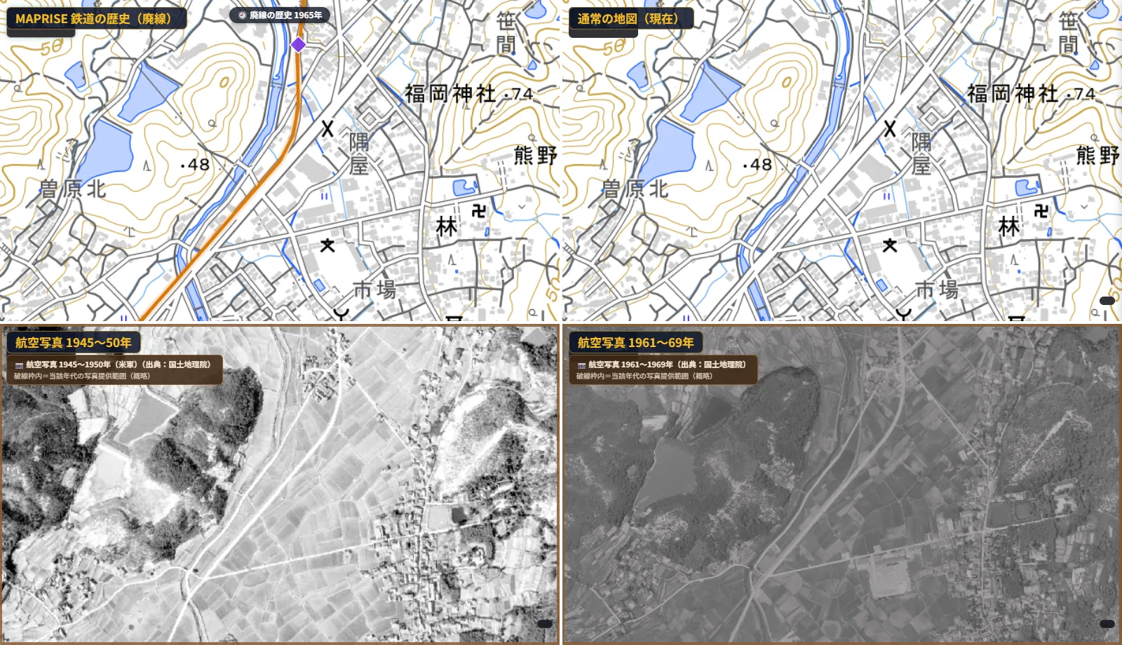
On the top left, the orange line curves gently from north to southwest, following the river. On today's map at the top right, a narrow road runs along the river in the same position, as if the curve of the track survived as the shape of the road. In both aerial photos below, a strip cuts diagonally across the rice fields.
The railways that served Hokkaido's coal mines — Shimizusawa, Yubari, Hokkaido
Next is Shimizusawa in Yubari, Hokkaido. Yubari prospered as a coal town. Shimizusawa is where the Mitsubishi Oyubari Railway branched off toward the coal mines deep in the mountains; that railway closed in 1987.
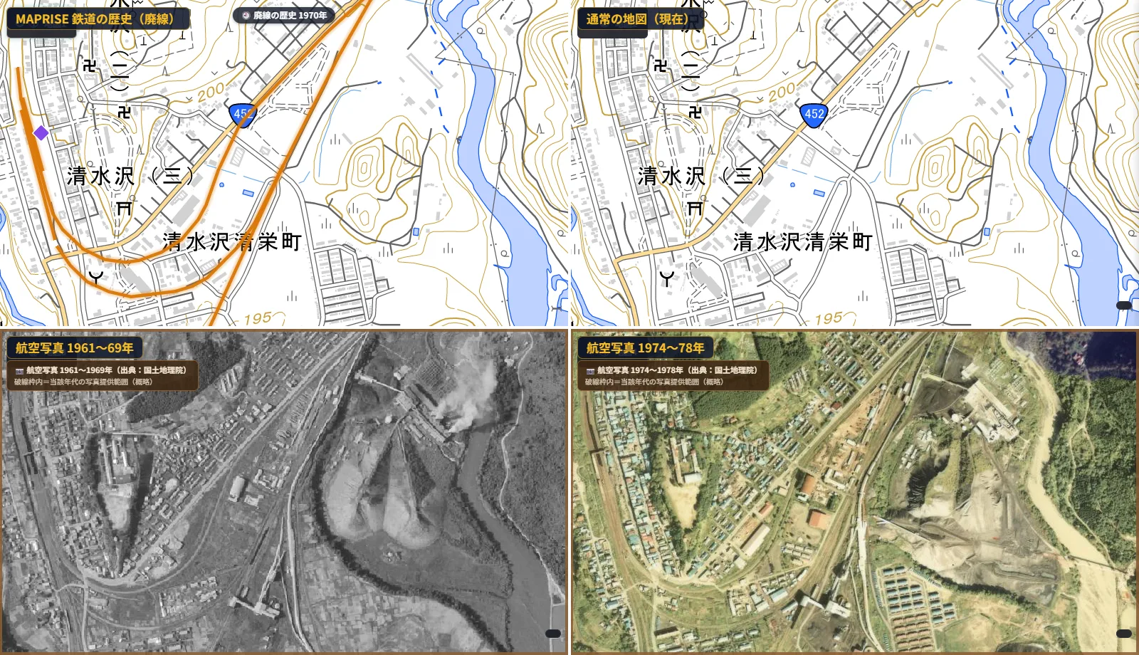
On the top left, several orange lines overlap and sweep in wide arcs. On today's map at the top right, those arcs have almost completely disappeared.
The aerial photos change the picture entirely. The 1961–1969 photo shows a broad yard with many parallel tracks, a facility giving off smoke, and large grey mounds spreading out like fans. The 1974–1978 photo still shows bundles of track, dark mounds and facilities. You can tell from the photos that this was a hub of a railway that carried coal.
Besides Yubari, Hokkaido had many railways that ran with the mines and disappeared with them, in places such as Bibai, Ashibetsu and Utashinai. As we showed in the previous post, the way Hokkaido's orange lines vanish one after another as you move the year forward reflects this history.
A line that carried freight to an industrial district — Amagasaki, Hyogo (Amagasaki Port Line)
The third place is the Daimotsu area of Amagasaki, Hyogo Prefecture. A branch of the Fukuchiyama Line (the Amagasaki Port Line) once ran south from Amagasaki toward the waterfront industrial district and Amagasaki Port. Passenger service ended in 1981, and the line itself closed in 1984.
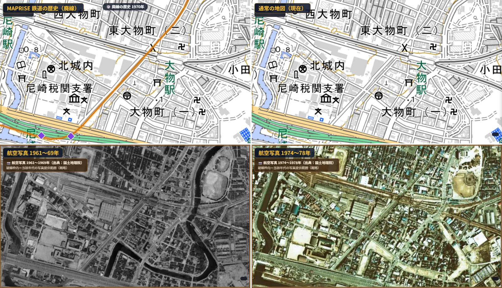
On the top left, the orange line cuts diagonally across a grid-like street pattern. Today's map at the top right also shows a diagonal road in the same position. A single road running at a different angle from all the others seems to tell the story of the old track.
In the aerial photos below, large sawtooth-roofed factory buildings stand right next to the diagonal track. It suggests a line that linked waterfront factories and the port, carrying raw materials and products.
A streetcar that disappeared in the Heisei era — Kitakyushu, Fukuoka (Nishitetsu Kitakyushu Line, Orio)
The last place is the south side of Orio Station in Yahatanishi Ward, Kitakyushu, Fukuoka Prefecture. Nishitetsu's streetcar, the Kitakyushu Line, once ran from Moji to Orio. It closed section by section, and the last remaining section, Kurosaki-ekimae to Orio, closed in 2000 (Heisei 12).
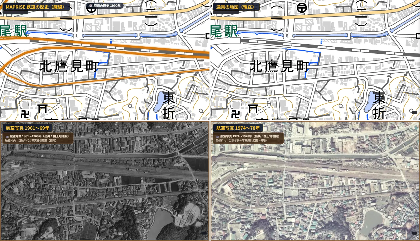
There are three orange lines on the top left, but the upper two are recorded in MAPRISE's data as former JR alignments. The one to look at is the single line to the south: the Nishitetsu Kitakyushu Line. In this section it ran on its own track rather than in the street, and at its western end it bent sharply toward Orio Station.
On today's map at the top right, a long east–west road runs in almost the same position. In both aerial photos below, the strip of track running east–west through the residential area is visible.
During the Heisei era, streetcars disappeared in other places too, such as Meitetsu's streetcar lines in Gifu (including the Gifu City Line and the Minomachi Line), which closed in 2005.
Disappearing lines are also a sign of changing times
Following closed lines on a map makes me a little wistful. Tracks that once carried coal, products and people every day are now roads and cycling paths, and without putting the photos side by side you can't even tell a railway was there.
But railways are not charities. Just maintaining the track, the trains and the stations costs a great deal of money. When there is less to carry and trucks and cars take over, it seems only natural, as the times change, that railways fade away. It is a little sad, but it also shows how much the times have changed.
Knowing that the road under your feet was once a railway changes how a familiar town looks. We hope the former-railway layer and the four-panel view help you learn the history of the land.
Our previous post explains how to read the former-railway layer and shows examples from Hokkaido to Kyushu.
Being upfront about the limits
- Line shapes are based on contributions to OpenStreetMap; we do not guarantee completeness or positional accuracy.
- Opening and closing years include estimates. Sections without a known year are shown in pale grey rather than the orange used for running sections.
- The coverage and timing of aerial photos vary by place. Even within the same era, some areas have no photo.
- Former track beds may be on private land or in restricted areas. Please take care if you visit.
If you have comments or questions, please write to info@maprise.jp.
The images in this post were cut out from the map areas of MAPRISE's four-panel view, with a caption added at the top left of each panel. The former-railway data is reference information processed by Vulcanz LLC from OpenStreetMap contributors (ODbL 1.0), Wikidata (CC0) and other sources, and opening and closing years include estimates. Maps and aerial photos are provided by the Geospatial Information Authority of Japan. Closing years and other details of each line are based on publicly available sources.
Tags: #Former railways #Railway history #Aerial photos #Four-panel view #Coal mining #Streetcars
Other-language share text (exception cases)
Quick share above follows our platform-locked language policy (X-family in Japanese, LinkedIn in English). The four panes below let you grab the opposite-language body when needed — e.g. introducing an English post to a Japanese audience on X, or posting a Japanese article to LinkedIn in Japanese. Each pane offers both a copy button and a direct intent link.
📝 廃線にも歴史あり ― 4分割の地図で、石炭・工場・路面電車の線路跡をたどる
鉄道は、人だけでなく石炭や材木、工場の製品を運ぶために敷かれてきました。MAPRISEの4分割表示で、廃線レイヤー・現在の地図・2つの時代の航空写真を並べ、自転車道になった線路、夕張の炭鉱鉄道、尼崎の工業地帯の貨物線、平成に姿を消した北九州の路面電車の跡をたどります。
https://maprise.jp/ja/blog/former-railways-four-panels/ #廃線 #鉄道の歴史
🆕 新しいブログ記事を公開しました。

《廃線にも歴史あり ― 4分割の地図で、石炭・工場・路面電車の線路跡をたどる》

鉄道は、人だけでなく石炭や材木、工場の製品を運ぶために敷かれてきました。MAPRISEの4分割表示で、廃線レイヤー・現在の地図・2つの時代の航空写真を並べ、自転車道になった線路、夕張の炭鉱鉄道、尼崎の工業地帯の貨物線、平成に姿を消した北九州の路面電車の跡をたどります。

👉 詳しくはこちら: https://maprise.jp/ja/blog/former-railways-four-panels/
📝 Closed Lines Have Histories Too — Tracing Coal, Factory and Streetcar Lines on a Four-Panel Map
Railways were laid not only for people but to carry coal, timber and factory goods. Using MAPRISE's four-panel view, we l…
https://maprise.jp/en/blog/former-railways-four-panels/ #Formerrailways #Railwayhistory
🆕 New on the MAPRISE blog.

《Closed Lines Have Histories Too — Tracing Coal, Factory and Streetcar Lines on a Four-Panel Map》

Railways were laid not only for people but to carry coal, timber and factory goods. Using MAPRISE's four-panel view, we line up the former-railway layer, today's map and aerial photos from two eras to trace a line that became a cycling path, a coal railway in Yubari, a freight line through Amagasaki's industrial district, and a Kitakyushu streetcar that disappeared in the Heisei era.

👉 Read the full post: https://maprise.jp/en/blog/former-railways-four-panels/

#Formerrailways #Railwayhistory #Aerialphotos #Four-panelview #Coalmining
Related posts
- Mapping Where Trains Used to Run — Former Railways and Stations, Slowly Fading2026-10-11
- Japan's Calderas in Black-and-White Hillshade and Colored Elevation ― Aso, Mashu, Toya, Hakone and More2026-10-03
- Solar Panels on Slopes and Cliff-Collapse Warning Zones in a 4-Panel View ― Places to Watch in Heavy Rain2026-10-03