In 2020 a slope on a condominium site in Zushi collapsed and killed an 18-year-old high school student walking on the road below. A property on a cliff comes with a view, and with a heavy duty to look after the ground beneath it. Using MAPRISE's 2-split view, we put a colored contour map next to sediment disaster warning areas (yellow zones) for the same area and looked for steep drops in Tokyo, Yokohama, Zushi, Kamakura, Osaka, Kobe, Kyoto, Sendai, Hiroshima, Onomichi, Matsuyama, Nagasaki, Kagoshima, Fukuoka and Kanazawa.
Hello from the MAPRISE development team.
On the morning of February 5, 2020, a slope on a condominium site in Zushi, Kanagawa Prefecture, collapsed onto the municipal road below. An 18-year-old high school student who was walking there died. According to press reports, the cliff was about 16 m high and roughly 66 tonnes of earth came down. A retaining wall stood up to about 8.2 m above the sidewalk, and the collapse came from the slope above it, which had no wall. The area was reported to have been designated a sediment disaster warning area (the "yellow zone") under Japan's Sediment Disaster Prevention Act.
This post is not an investigation of the accident. It is an attempt to sort out what it means to own property on top of a cliff, and then to look for steep drops in Japanese cities using MAPRISE.
Key points
- The owner of a cliff-top property is responsible for the slope and retaining wall beneath it.
- Finding "where the steep cliff tops are" is possible on a map: look at a colored contour map (elevation shown in color) next to sediment disaster warning areas (yellow zones).
- MAPRISE's 2-split view (available on the Free plan) shows the contour map on the left and the warning areas on the right, for the same area at the same scale, so you can compare height differences and zones at a glance. This post shows examples from Tokyo, Yokohama, Zushi, Kamakura, Osaka, Kobe, Kyoto, Sendai, Hiroshima, Onomichi, Matsuyama, Nagasaki, Kagoshima, Fukuoka and Kanazawa.
What is known about the Zushi accident
Based on press reports and public research, as far as we could confirm:
- The National Institute for Land and Infrastructure Management (NILIM) reportedly attributed the collapse not to water but to weathering of the slope by low temperatures, wetting and drying, and wind.
- In 2021 the student's parents sued the condominium's unit owners, the owners' association and the management company for about 118 million yen.
- Reports say the owners' side agreed in June 2023 to pay 100 million yen, using insurance.
- In December 2023 the Yokohama District Court reportedly ordered the management company to pay damages, finding that it could have recognized the danger and did not respond properly. A former employee who had been referred to prosecutors was not indicted.
- In 2023 the parents also sued Kanagawa Prefecture, which had surveyed the slope shortly before the accident.
So responsibility was tested in court not only for the owners but also for the management company and the government. We do not think it is accurate to say that the owners alone are responsible. Still, the basic legal principle below is worth knowing.
Liability of the owner of a structure on land
Article 717 of the Civil Code says that when a structure on land (a building, a wall, a retaining wall) is defective in construction or upkeep and causes harm to others, the occupant is liable first; if the occupant took the care needed to prevent the harm, the owner is liable. The owner's liability does not depend on fault: it is strict liability.
At a condominium the site is co-owned, and slopes and retaining walls are common areas, so the matter can concern every unit owner.
- Inspecting and repairing a retaining wall or slope is for the owners (unit owners and their association) to decide and pay for.
- A management company advises and acts within its contract; it is not a party that takes over the upkeep of the wall. As the Zushi ruling shows, though, it can be held liable if it could recognize a danger and did not act.
- Government may guide and support, but it does not repair a private owner's retaining wall for them.
Land on a high bluff with a view is land whose price includes a duty to protect what lies beneath it. This applies well beyond Zushi. This post is a general summary and not legal advice; please consult a lawyer for any specific case.
What is a "yellow zone"?
The Sediment Disaster Prevention Act has prefectures designate areas at risk of landslides, debris flows and slope failures.
- Sediment Disaster Warning Area (yellow zone): an area where a sediment disaster could harm residents. For steep slopes, one of the criteria is a slope of 30 degrees or more and a height of 5 m or more.
- Special Warning Area (red zone): within those, areas where buildings could be destroyed and lives are at particular risk. Construction and development are restricted.
In property transactions, whether the land lies inside such an area must be explained in the important matters briefing. Being outside an area does not guarantee safety, and whether a retaining wall exists is a separate matter from designation.
Finding steep drops with MAPRISE
"Is this land at the top of a cliff or at the bottom?" An address alone rarely tells you. On MAPRISE you can check it on the map:
- Turn on the colored contour map, a base map that shows elevation in color. High ground is warm (red, brown), low ground is cool (blue, green). Where the color changes sharply, there is a cliff or a steep slope.
- Switch to 2-split view and show the sediment disaster warning areas (debris flow, steep slope, landslide) from the Hazard Map Portal of the Ministry of Land, Infrastructure, Transport and Tourism and the Geospatial Information Authority of Japan (GSI) on the other screen.
- The two screens move together at the same position and scale. Where you spot a sharp color change on the left, you can see on the right whether yellow (yellow zone) or red (special warning area) lies along it.
Overlaying both on a single map makes both harder to read. Side by side, the height difference and the zone can each be read clearly. Colors are assigned automatically for each view, so colors cannot be compared between images.
Below are examples from Japanese cities where a yellow zone sits along a sharp change in color. In every image, the left is the colored contour map and the right is the sediment disaster warning areas. Elevations are approximate values from the GSI elevation API.
Tokyo 1: Azabu, Minato Ward — a yellow band along the plateau edge
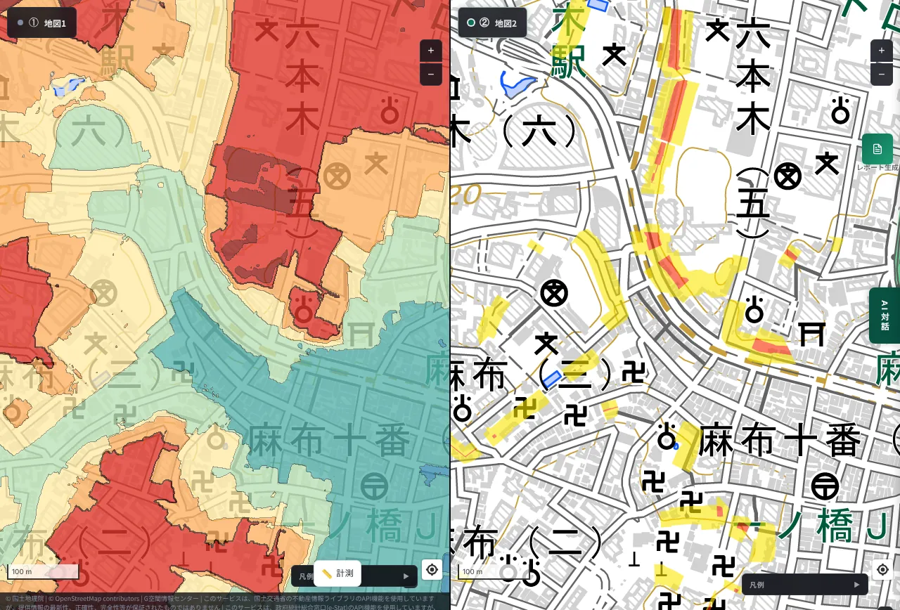
The plateau around Moto-Azabu is about 20 m above sea level; the lowland toward Azabu-Juban is around 5 to 7 m. That is a drop of more than ten meters within a few hundred meters. Along the boundary between the red plateau and blue lowland on the left, a thin yellow band (steep-slope warning area) runs on the right. It is a high-end residential district of embassies, mansions and apartment buildings, but at the foot of the plateau edge there are slopes and retaining walls.
Tokyo 2: Koishikawa/Kohinata, Bunkyo Ward
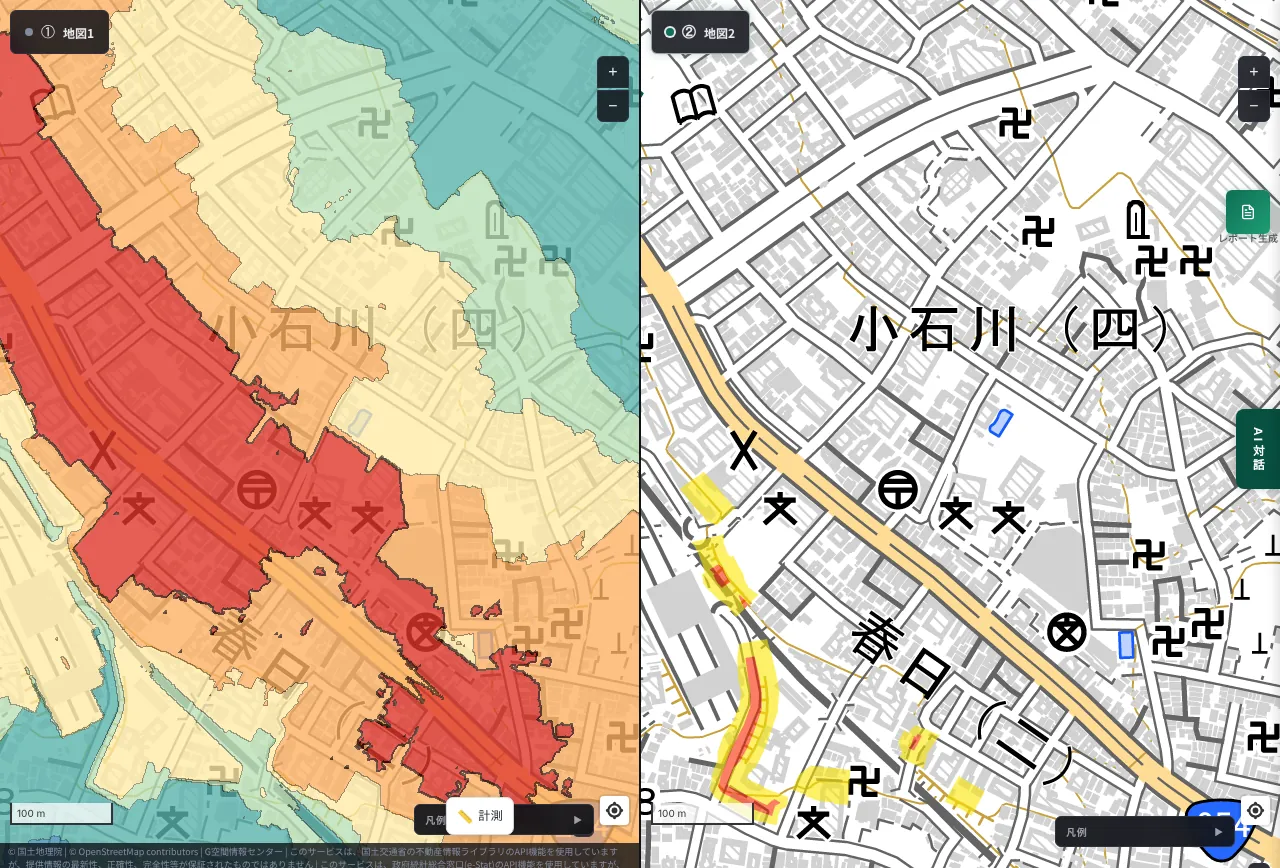
The Kohinata plateau is about 24 m; the lowland on the Kasuga side is about 7 m, a difference of about 17 m. Yellow areas follow the edge, with some red (special warning) areas. Bunkyo is known as a ward of slopes and bluffs.
Tokyo 3: Osaki to Kita-Shinagawa, Shinagawa Ward
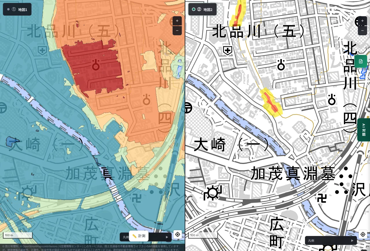
The Kita-Shinagawa plateau juts toward the lowland near Osaki Station, with a yellow band along its edge. Even near a major terminal station, plateau edges carry warning areas.
Yokohama: the edge of the Yamate plateau (Naka Ward)
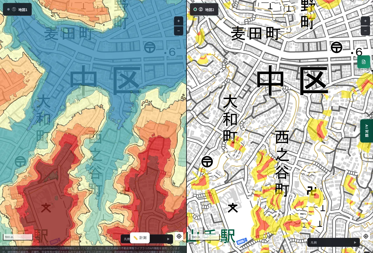
Yamate in port city Yokohama is known for the height difference between the waterside lowland and the plateau of Western-style houses. The lowland near Mugita-cho is about 1 m above sea level and the Yamate plateau 30 to 37 m, a drop of more than 30 m within about 1 km. On the left the plateau is red and the lowland blue. On the right, yellow and red zones sit along its edge as small patches. Where valleys cut in, the zones are broken into small pieces too.
Osaka: the Ikoma foothills (Ishikiri, Higashiosaka)
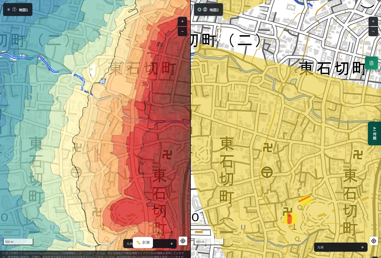
We looked at the edge of the Uemachi Plateau (Osaka Castle to Tennoji) in Osaka, but within our view we could hardly find any yellow zones. So we looked at the Ikoma foothills, where the city meets the mountain. Across about 1 km of the view, the west side is about 9 m and the east side about 175 m, a climb of more than 160 m. The fan-shaped yellow area is a debris-flow warning area, and houses extend into the lower part of the fan.
Kobe: urban area hugging the Rokko foothills (Kitano, Chuo Ward)
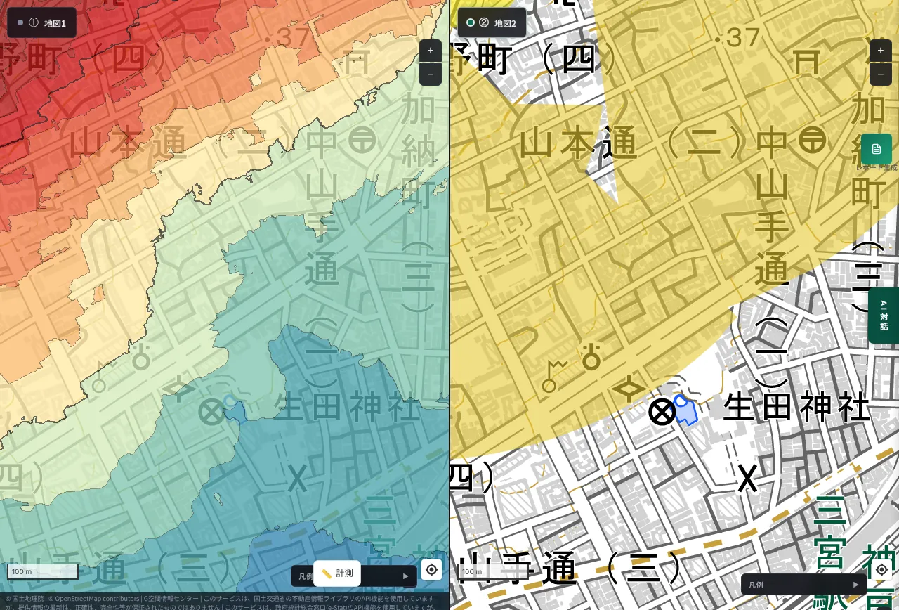
The center of the view is about 20 m above sea level; about 700 m to the north it is more than 70 m. In Kobe, where land between sea and mountain is narrow, the city clings to the foot of Rokko. The large yellow fan is a debris-flow warning area. There are warning areas not far from Sannomiya Station.
Hiroshima: the edge of Hijiyama (Minami Ward, near Danbara)
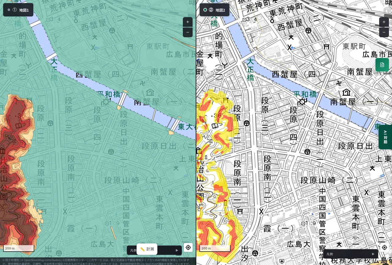
Hijiyama rises like an island in the middle of Hiroshima's urban area. The hill's edge is in the 20 m range, while the Danbara neighborhood to its east is around 1 to 4 m, so the ground rises about 20 m from the flat city. The hill shows as dense red-brown on the left. On the right, yellow and red zones run along its edge. Even a hill standing in a flat city has zones along its edge.
Nagasaki: the slope east of Nagasaki Station (Inasa to Mifunekura-machi)
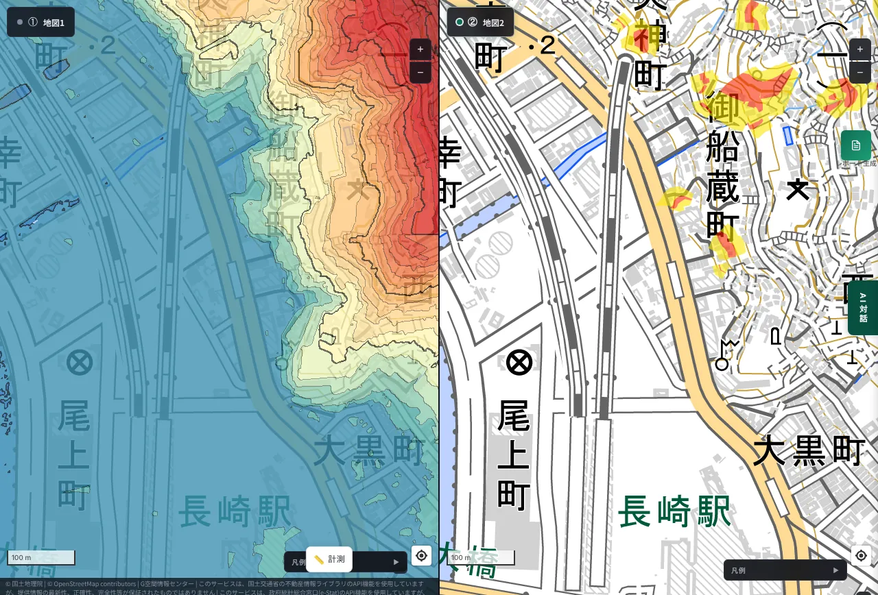
East of Nagasaki Station, a slope rises right behind the lowland. The lowland near the station is 3 to 4 m, the mid-slope about 77 m and the upper part more than 180 m, a climb of nearly 180 m within about 1 km. On the left the color turns from blue to red in one go; on the right, yellow and red zones are scattered on the upper slope. In Nagasaki, "the city of slopes", houses clinging to hillsides are an everyday sight. For the terrain around the station, see also Nagasaki Station at 1 m.
Kyoto: the foot of Higashiyama (Yasaka Pagoda and Kiyomizu area)
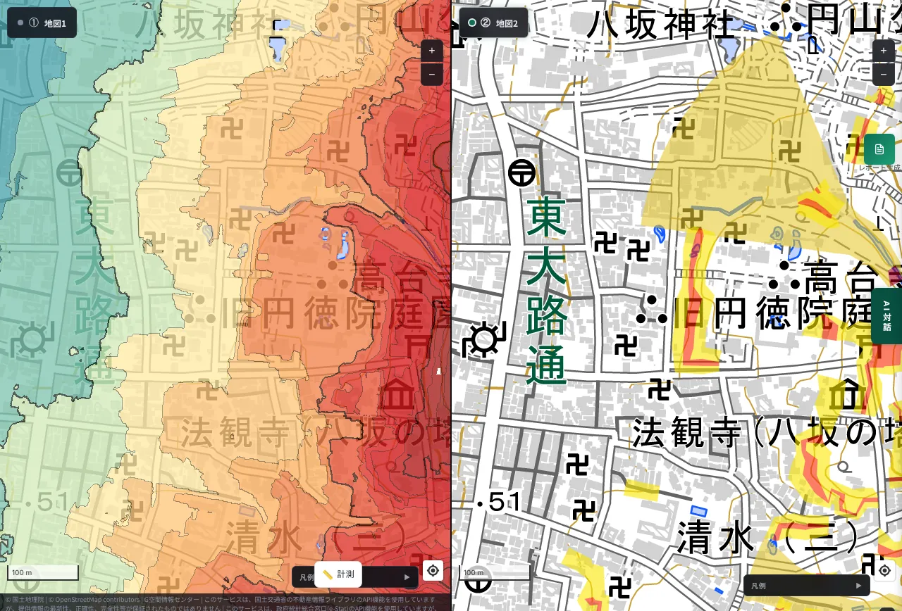
The area around the Yasaka Pagoda, crowded with tourists, is about 50 to 60 m above sea level; a few hundred meters east it exceeds 100 m. On the right, a large yellow fan (debris-flow warning area) and red zones sit at the foot of the hills. Even a historic townscape spreads over the foot of a mountain.
Sendai: the terrace edge of Aobayama (Aoba Ward, Kawauchi to Yamayashiki)
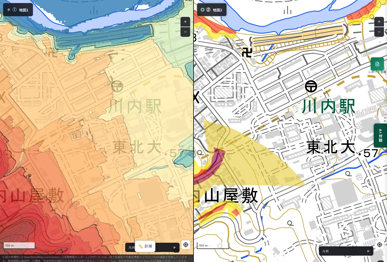
Near Kawauchi Station the ground is about 61 m; about 600 m to the southwest on the Yamayashiki side it is about 121 m, a difference of about 60 m. On the left the flat district is yellow to orange and the heights to the southwest turn red. On the right, a large yellow fan with a red band overlaid lies along the edge.
Zushi: mountains close in north of the station (Enmyoji to Sakurayama, Zushi City)
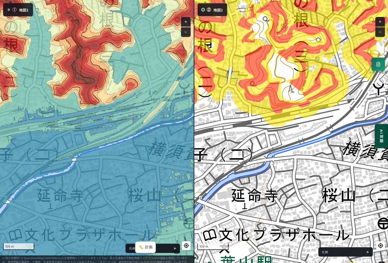
This is not the site of the accident, but another part of the same city, north of the station. The lowland is about 4–7 m above sea level, and about 700 m to the north, the mountain reaches roughly 50 m. On the left, the colors change sharply from blue lowland to red mountain. On the right, yellow and red bands trace the mountain's edge in waves. Mountains rising right behind a seaside town is a feature shared by Zushi and Kamakura.
Kamakura: the valleys west of the station (west of Onari-cho, Kamakura City)
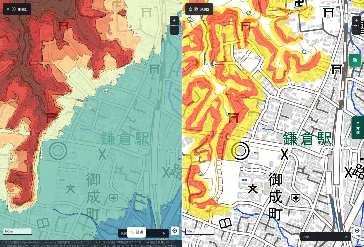
The lowland around Kamakura Station is about 5–10 m above sea level. About 800 m to the west and northwest, the elevation reaches nearly 70 m. On the left, a reddish-brown mountain spreads west of the station; on the right, yellow and red zones run intricately along the edges and valleys. Kamakura's terrain is full of small valleys called "yato" that cut into the hills, and homes continue deep along them.
Onomichi: the hillside of Senkoji and the seaside town (Doudo-cho, Onomichi City)
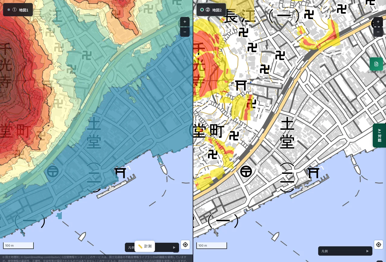
Onomichi is a long, narrow town between the sea and the hills. The waterfront is a few meters above sea level, and about 600 m of horizontal distance inland, the elevation exceeds 100 m. On the left, the hillside of Senkoji rises sharply in red from the blue waterfront lowland. On the right, yellow and red zones are scattered over that slope. The famous scenery of slopes and stone steps is also a life lived on steep ground.
Kagoshima: the slopes of Shiroyama (Shiroyama-cho to Terukuni-cho, Kagoshima City)
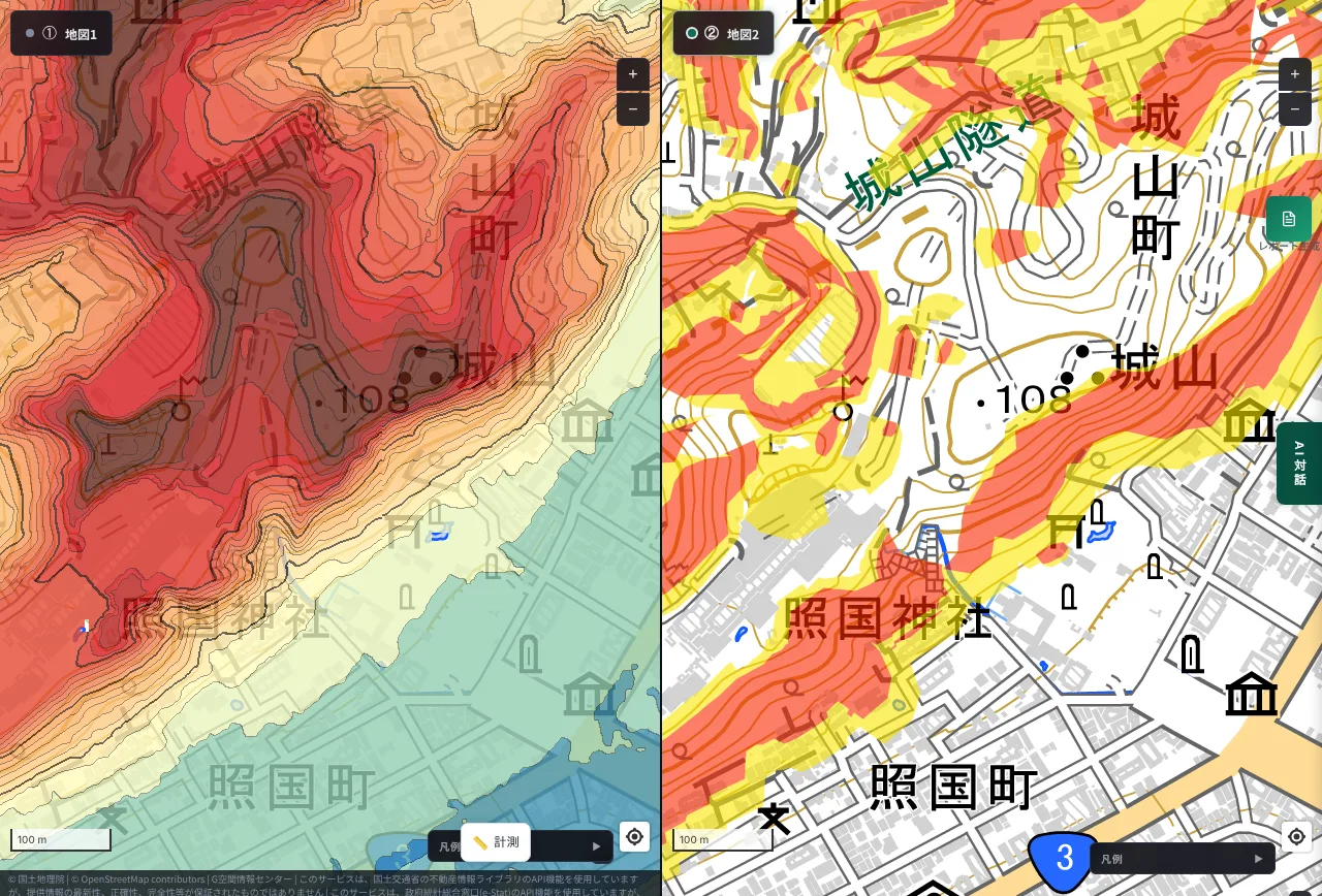
Shiroyama, right next to central Kagoshima, is about 100 m high. The city and port side to the east are around 5 m, so there is a difference of about 90 m within a few hundred meters. On the left, Shiroyama spreads in deep red; on the right, yellow and red bands line its edge. Beyond the volcanic ash from Sakurajima, there is another kind of risk right next to the city: slopes.
Matsuyama: the hill of Matsuyama Castle (Shiroyama Park, Matsuyama City)
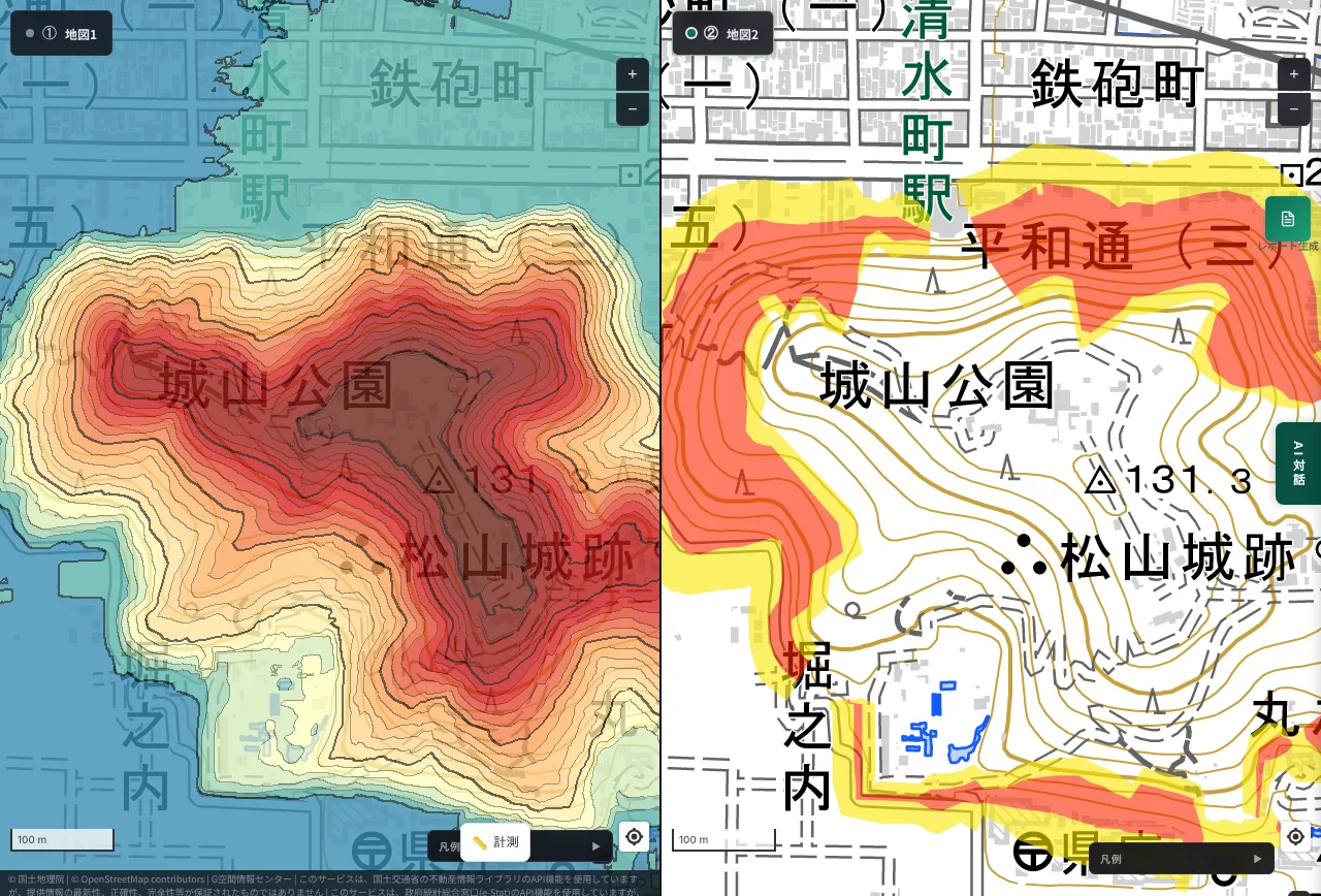
Matsuyama Castle stands on a hill that rises like an island from the flat city. The summit is about 130 m above sea level and the surrounding city is around 20–30 m, so the hill is roughly 100 m tall. On the right, bands of yellow and red surround the hill all the way around. As with Hijiyama in Hiroshima, the edge of a hill standing in a flat city is also covered by zones.
Fukuoka: the hills behind the city (Nagaoka, Minami Ward, Fukuoka City)
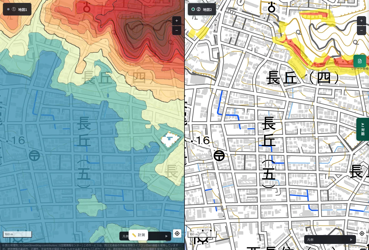
Fukuoka is thought of as a flat city, but hills and mountains lie behind the urban area. The lowland around Nagaoka is about 10–20 m above sea level, and about 500–700 m to the northeast, the elevation reaches 80–90 m. On the left, a red hill rises northeast of the blue urban area; on the right, bands of yellow and red follow its edge. The zones are concentrated at the top of the view, and houses extend right to the foot of the hill.
Kanazawa: the foot of Utatsuyama (Higashiyama to Yamanoue-machi, Kanazawa City)
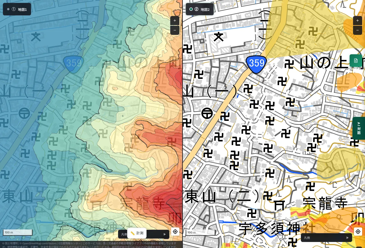
Higashiyama in Kanazawa lies east of the Asano River and is known for its temples and teahouse streets. The lowland to the west is about 10 m above sea level, and about 500–600 m to the east, the elevation reaches 70–80 m. On the left, the colors shift step by step from the blue lowland toward Utatsuyama in the east. On the right, large yellow-to-orange zones and red zones spread across the mountain side of the view. This historic temple district also lies at the foot of a mountain.
What we took from this
- Along the plateau edges of Tokyo and Yokohama, steep-slope warning areas run as thin ribbons or small patches for kilometers, with houses and condominiums above and roads and homes below.
- In Osaka, Kobe, Kyoto and Sendai, foothill zones spread as areas into the urban fabric.
- In Hiroshima, even a hill standing in a flat city has zones along its edge.
- In Nagasaki and Onomichi, the slope itself is the residential area.
- In towns like Zushi, Kamakura and Kagoshima, where mountains rise right behind the sea or port, the urban area and the foot of the mountain almost touch. A hill inside a flat city like Matsuyama's, and the hills and mountain feet behind a city like Fukuoka's Nagaoka and Kanazawa's Higashiyama, are the same.
- All of these overlap with hilltop neighborhoods valued for their views and quiet. The appeal and the risk come from the same terrain.
For people who own or are thinking of buying cliff-top property
As general considerations only:
- Check whether your site and neighboring land lie in a zone. Municipal offices and hazard maps can tell you.
- Look at the inspection records for retaining walls and slopes. Cracks, bulging, clogged weep holes or cracks in the slope should go to a specialist early.
- Check whether your association's long-term repair plan includes the wall and slope. Often it does not.
- Check your liability insurance (facility liability coverage). Insurance was reportedly used in the Zushi settlement.
- Before buying, check the zone, the state of the wall and the management record. The view is priced in; so are the upkeep costs.
On aging retaining walls, inheritance, vacant houses and the difficulty of administrative action, see Counter-measures for Aging Infrastructure in Urban Areas ①: The Overlooked Problem of Retaining Walls.
With MAPRISE, you can check the "cliff risk" of a site yourself
Every screen in this post was shown on MAPRISE. No special skills are needed.
- See height differences and yellow zones at the same time: put the colored contour map and sediment disaster warning areas side by side in 2-split view, for the same area. Show a site you are considering, or your own property's surroundings.
- Other hazards and land prices on the same screen: floods, tsunami, fill-land regulation areas, zoning, land prices and crime can be overlaid or compared in 4-split view. See the layer list for available data and data sources for origins.
- Ask the AI how to read the map: ask things like "What is the elevation here, and what is the sediment disaster risk?" while looking at the map. AI answers are reference information and never guarantee safety, even outside a zone.
- Put it into a report: summarize what you found in a PDF or other report.
When buying land or owning and managing a property, checking the unseen slope at your feet on a map before you visit is the first step. MAPRISE makes that check possible in minutes. 2-split view is available even on the free Free plan (every screen in this post can be reproduced in 2-split view). 4-split view requires Starter or above. Other features also vary by plan; see pricing for details.
Open MAPRISE and look for the "cliff edge" of your own city
Limits of this article
- Our description of the accident is based on press reports and public material; we have not seen the court judgments themselves. Amounts and details differ between reports.
- In Zushi, the reported collapse was of the slope above the retaining wall, not the wall itself. We make no claim about whether a wall was reinforced.
- Warning areas are approximate designations as of the survey; being outside one does not mean safe. The screens display Hazard Map Portal tiles, and boundary positions may be inexact.
- Elevations are approximate values from GSI data, with errors of a few meters.
- None of the locations refers to a specific property or owner. We chose each spot where colors change sharply; they are not city-wide trends.
- For the Uemachi Plateau in Osaka we could not confirm yellow zones within our view.
- For readability, the images were captured with the legends collapsed. The legend (yellow = warning area, red = special warning area) is shown on the MAPRISE screen.
Related reading: the sequel, Don't Choose a Cliff-Top Home on View and Elevation Alone (retaining walls, disclosure rules, land prices and yellow zones), solar panels on slopes and landslide warning areas, fill-land regulation and large-scale fill, Yamanote vs. Shitamachi by elevation, Nagasaki Station at 1 m, and Musashi-Kosugi's terrain and hazards. Questions and comments are welcome at info@maprise.jp.
Sources
- Press coverage and commentary on the Zushi slope collapse (Kanagawa Shimbun, Nikkei xTECH, Security News and others)
- NILIM (Ministry of Land, Infrastructure, Transport and Tourism) investigation into the cause of the Zushi slope collapse
- MLIT / GSI Hazard Map Portal (sediment disaster warning areas)
- GSI elevation API
Images are MAPRISE 2-split screens (left: colored contour map; right: sediment disaster warning areas from the Hazard Map Portal). Elevations come from GSI and warning areas from MLIT/GSI data, processed by Vulcanz LLC as reference information; they do not guarantee the safety or value of any individual parcel. Parts of the maps are provided by OpenStreetMap contributors and the Geospatial Information Authority of Japan.
Tags: #retaining wall #sediment disaster warning area #yellow zone #steep slope #elevation #colored contour map #split view #Zushi #Kamakura #Onomichi #Kagoshima #Matsuyama #Fukuoka #Kanazawa #Tokyo #Yokohama #Osaka #Kobe #Hiroshima #Nagasaki #Kyoto #Sendai #liability
Other-language share text (exception cases)
Quick share above follows our platform-locked language policy (X-family in Japanese, LinkedIn in English). The four panes below let you grab the opposite-language body when needed — e.g. introducing an English post to a Japanese audience on X, or posting a Japanese article to LinkedIn in Japanese. Each pane offers both a copy button and a direct intent link.
📝 崖の上に建つ不動産は、足元の斜面と擁壁を誰が守るのか ― 逗子の事故と、全国の都市のイエローゾーンを2分割の標高図で見る
2020年、逗子市で、マンション敷地の斜面が崩れ、下の道を歩いていた18歳の高校生が亡くなりました。崖の上の不動産には、眺望と引き換えに、足元の斜面や擁壁を管理する重い責任がつきまといます。MAPRISEの2分割表示で、色分け等高線と土砂災害警戒区域(イエローゾーン)を同じ範囲で並べ、東京・横浜・逗子・鎌倉・大阪・神戸・京都・仙台・広島・尾道・松…
https://maprise.jp/ja/blog/yellow-zone-cliff-retaining-wall/ #擁壁 #土砂災害警戒区域
🆕 新しいブログ記事を公開しました。

《崖の上に建つ不動産は、足元の斜面と擁壁を誰が守るのか ― 逗子の事故と、全国の都市のイエローゾーンを2分割の標高図で見る》

2020年、逗子市で、マンション敷地の斜面が崩れ、下の道を歩いていた18歳の高校生が亡くなりました。崖の上の不動産には、眺望と引き換えに、足元の斜面や擁壁を管理する重い責任がつきまといます。MAPRISEの2分割表示で、色分け等高線と土砂災害警戒区域(イエローゾーン)を同じ範囲で並べ、東京・横浜・逗子・鎌倉・大阪・神戸・京都・仙台・広島・尾道・松山・長崎・鹿児島・福岡・金沢の、急な高低差の場所を探しました。

👉 詳しくはこちら: https://maprise.jp/ja/blog/yellow-zone-cliff-retaining-wall/
📝 Who Looks After the Slope and Retaining Wall Beneath a Cliff-Top Property? ― The Zushi Accident, and Yellow Zones Across Japan on a Split-Screen E…
In 2020 a slope on a condominium site in Zushi collapsed …
https://maprise.jp/en/blog/yellow-zone-cliff-retaining-wall/ #retainingwall #sedimentdisasterwarningarea
🆕 New on the MAPRISE blog.

《Who Looks After the Slope and Retaining Wall Beneath a Cliff-Top Property? ― The Zushi Accident, and Yellow Zones Across Japan on a Split-Screen Elevation Map》

In 2020 a slope on a condominium site in Zushi collapsed and killed an 18-year-old high school student walking on the road below. A property on a cliff comes with a view, and with a heavy duty to look after the ground beneath it. Using MAPRISE's 2-split view, we put a colored contour map next to sediment disaster warning areas (yellow zones) for the same area and looked for steep drops in Tokyo, Yokohama, Zushi, Kamakura, Osaka, Kobe, Kyoto, Sendai, Hiroshima, Onomichi, Matsuyama, Nagasaki, Kagoshima, Fukuoka and Kanazawa.

👉 Read the full post: https://maprise.jp/en/blog/yellow-zone-cliff-retaining-wall/

#retainingwall #sedimentdisasterwarningarea #yellowzone #steepslope #elevation
Related posts
- Don't Choose a Cliff-Top Home on View and Elevation Alone: Retaining Walls, Disclosure Rules, Land Prices and Yellow Zones, City by City (Part 2)2026-10-25
- Did the Rich Move Uphill to Avoid Floods? Testing 'Yamanote vs Shitamachi' in Tokyo, Nagoya, Osaka and Fukuoka with Four Maps2026-10-24
- Musashi-Kosugi, Then and Now, and Where Its Hazards Stand Today ― Re-reading the Location Through Elevation, Landform and History2026-10-21