MAPRISE colours buildings by seismic-standard generation using construction years from PLATEAU. We captured five areas across Japan where pre-1981 buildings stand out (Mojiko, Wakamatsu, Kanazawa Higashiyama, Kyoto Nishijin, Takamatsu) and read them against the history of each place.
Hello from the MAPRISE development team. This time we simply look at the map.
MAPRISE has a layer that colours buildings by seismic-standard generation, using the construction years in MLIT's PLATEAU 3D city model. Browsing PLATEAU-covered cities across Japan with it, you find towns where pre-1981 buildings show up as large patches of red and orange. And almost every one of those towns has a reason.
Below are five areas we captured, read together with the history of the land.
How to read the colours, and what to keep in mind
Old and new seismic standards
In 1981 the Building Standard Law Enforcement Order was revised and the "new seismic standard" was introduced; the 1978 Miyagi-ken-oki earthquake is said to have been one trigger. The old standard assumed buildings would not collapse at around seismic intensity 5; the new one aims to avoid collapse that endangers lives even at around upper 6. Municipal documents also note that old-standard buildings suffered markedly in the 1995 Great Hanshin-Awaji Earthquake.
The map colours buildings by construction year:
- Red: before 1971 (to 1970)
- Orange: old standard (1971–1981)
- Yellow-green: new standard (1982–1999)
- Green: 2000 standard or later
- Pale grey: construction year unknown
Please read these caveats first
All figures and colours here are reference information.
- Colours are cut by year. The new standard applies to building confirmations from 1 June 1981, so a 1981 building can be either. The colour is not the actual confirmation date.
- Construction-year data varies a great deal between municipalities. Surveying representative spots in major cities the same way, we found spots with almost no construction years (the east-Tokyo wards, Osaka, Nagoya, Yokohama and Sendai survey spots), and others, such as around Hakata Station in Fukuoka, where only about 15% of buildings had a year. Buildings without a year are drawn pale grey. The five areas below are ones where roughly 70–80% of buildings had a year.
- Percentages use buildings visible on the captured screen that have a known year. They are not area-wide statistics.
- Old does not mean unsafe. Some pre-1981 buildings have been retrofitted, and some post-1981 buildings were damaged in earthquakes. Always have a licensed architect assess any individual building.
1. Mojiko (Moji Ward, Kitakyushu) — a continental trade port, and what came after
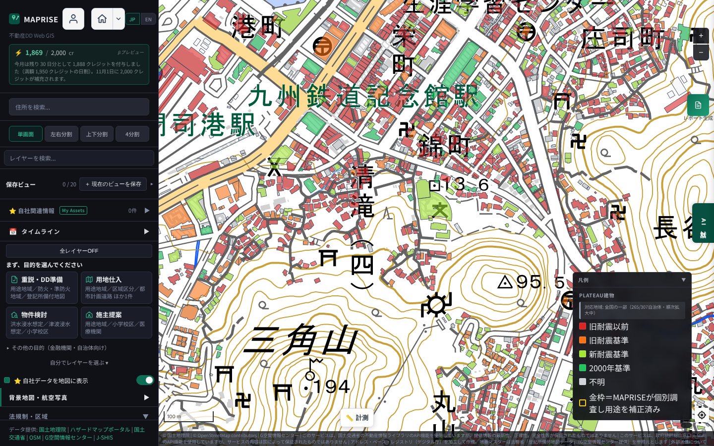
On this screen, about 75% of buildings with a known year date from 1981 or earlier (red plus orange; 79% had a year) — the highest of the areas we checked.
History. Moji was designated a special export port for coal, rice, wheat, flour and sulphur in 1889, with a Nagasaki Customs branch office. It became a key port for sending military supplies and soldiers in the Sino- and Russo-Japanese wars, and the present Moji Port Station building was completed in 1914. It prospered as a hub for continental routes and was counted among Japan's major ports alongside Kobe and Yokohama. After the war overseas trade shrank and demand for the port gradually declined. When demolition of the former Mitsui Club was proposed in 1987, a preservation movement began, and "Mojiko Retro" opened in 1995.
Reading the map. The red patches suggest that the streetscape of the prosperous era remained without large-scale rebuilding. This is our own reading of the distribution, not a check of individual buildings' histories.
2. Wakamatsu (Kitakyushu) — the port that shipped Chikuho coal
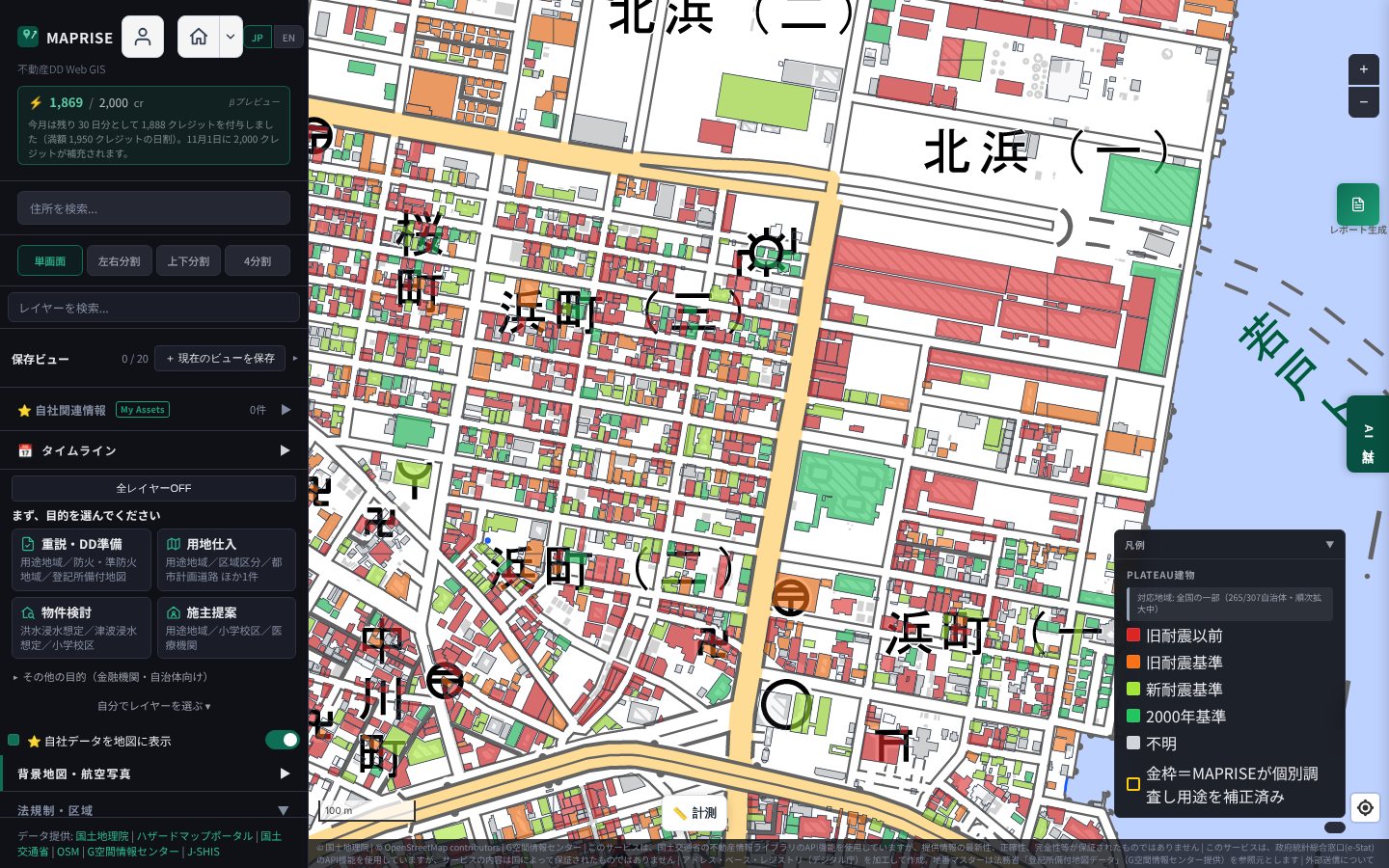
About 71% of known-year buildings date from 1981 or earlier (79% had a year). In addition to the old blocks, large red areas (apparently warehouses and factories) line the port side.
History. Wakamatsu grew as the shipping port for coal mined upstream of the Onga River. The Horikawa Canal (1763) linked the Onga River to Dokai Bay, and Wakamatsu Port was built in 1892; stone-block quay walls from that era remain. At the peak of the postwar coal boom, in the early 1960s, an average of about 2,100 ships a day entered and left Dokai Bay, according to Kitakyushu City; today it is less than half.
Reading the map. As the port and town were shaped in the coal era and then shifted toward industry, rebuilding in the centre appears to have been limited. Note that many buildings share the same year here (1918, 1936, 1938), which may reflect how data were compiled rather than actual construction years — treat individual years as reference values.
3. Kanazawa, around Higashi Chaya District — an Edo-period layout still alive
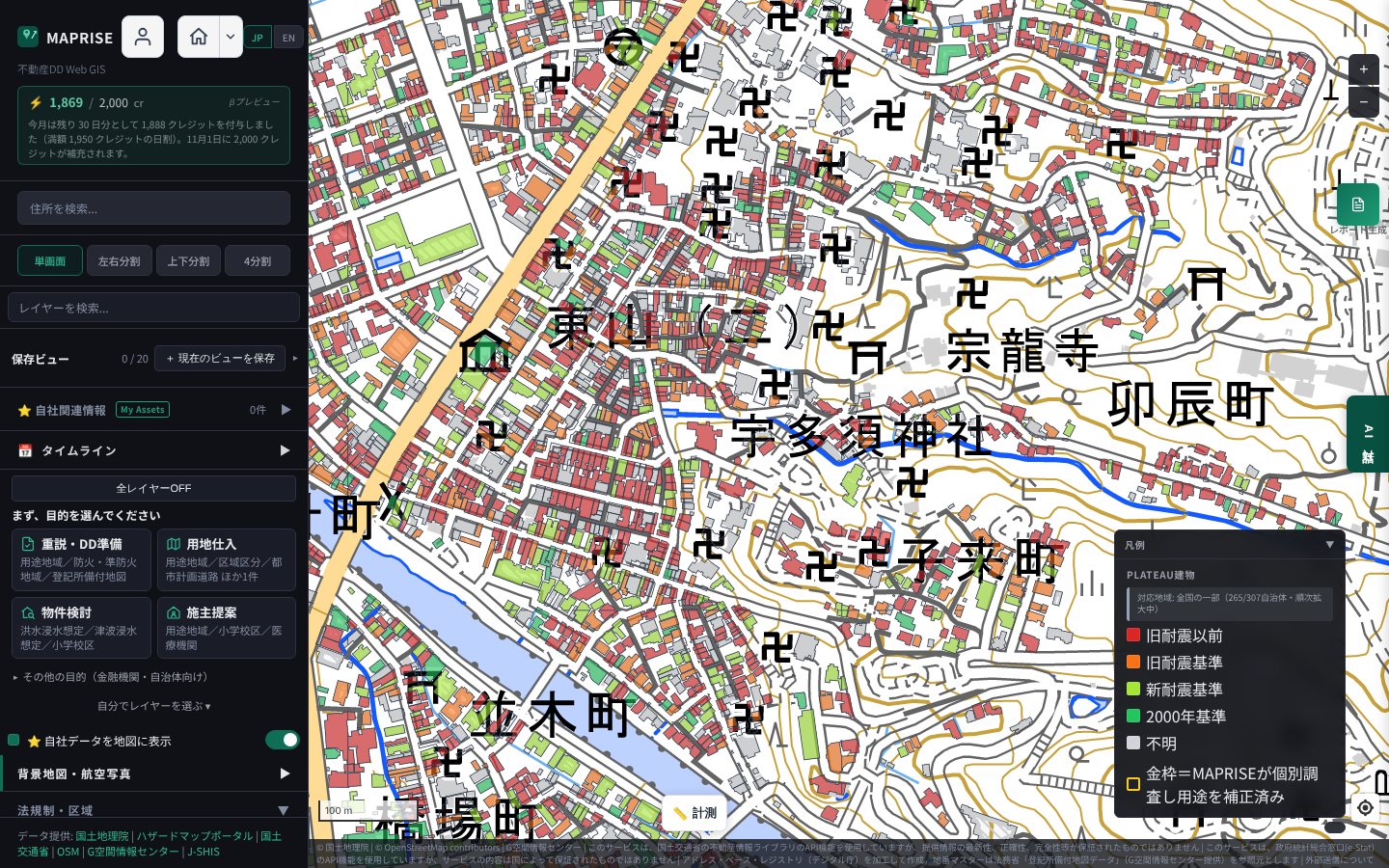
About 74% of known-year buildings date from 1981 or earlier (71% had a year).
History. Higashi Chaya is said to have been set up in 1820 as a "tea-house town" under Maeda Nariyasu, 12th lord of the Kaga domain, by gathering tea houses scattered around the castle town. Its stone-paved streets and lattice-fronted houses remain, and it is a nationally designated Important Preservation District for Groups of Traditional Buildings.
Reading the map. Some of the red buildings here likely belong to protected historic wooden architecture. So a high pre-1981 share does not simply mean "renewal has stalled": a streetscape deliberately kept also carries the separate task of checking and improving seismic performance — a theme shared by historic districts nationwide.
4. Kyoto Nishijin — a craftsmen's quarter since the Onin War
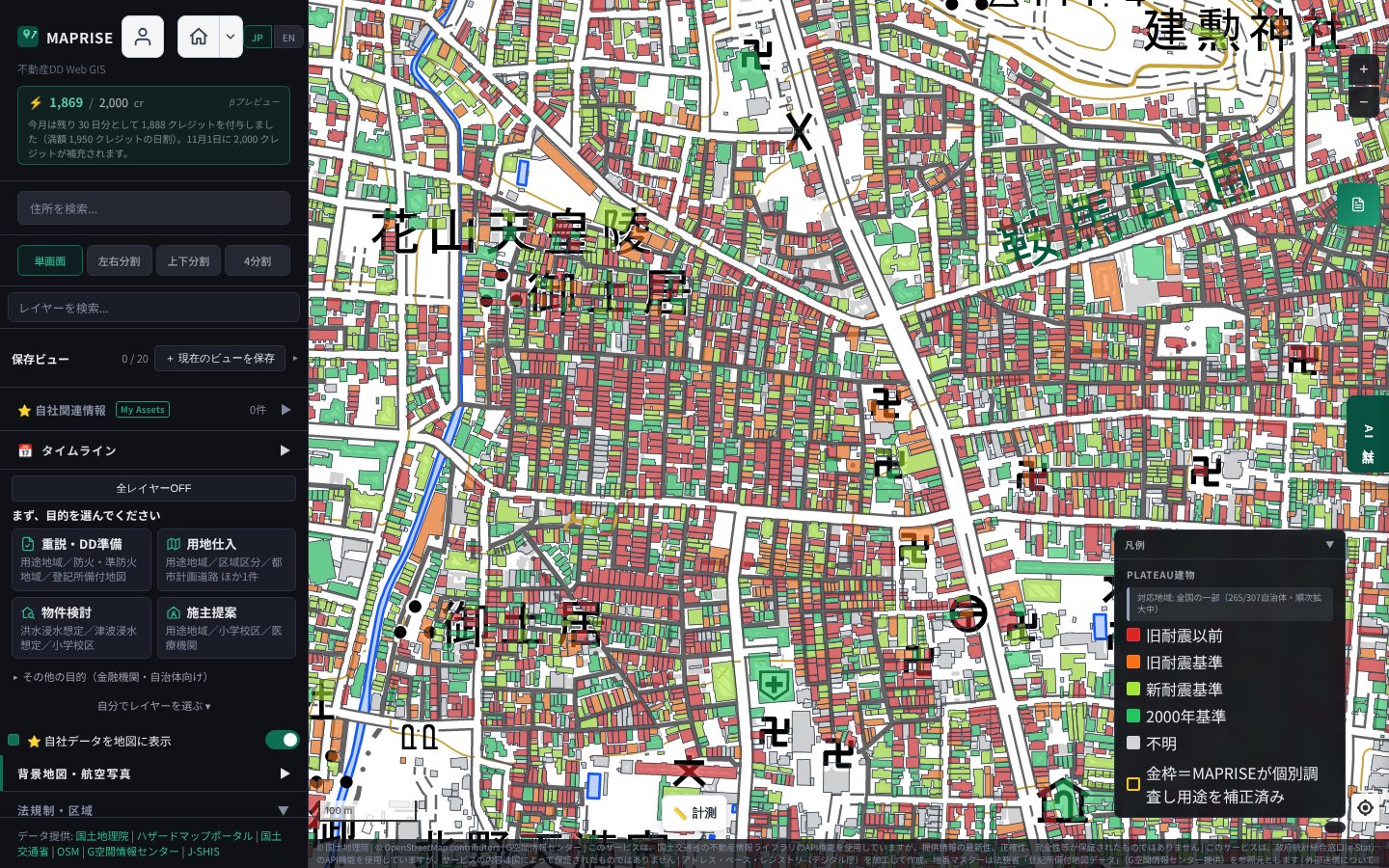
About 51% of known-year buildings date from 1981 or earlier — lower than elsewhere — but the data coverage is the highest (86%) and the building count large, so red looks densest here.
Clicking a building shows its construction year, seismic standard, structure and more.
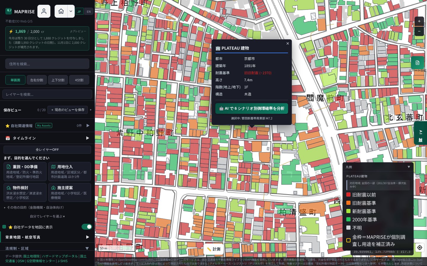
History. The name Nishijin ("west camp") comes from the area where Yamana Sozen's western army set up camp in the Onin-Bunmei War (from 1467). After the war, scattered weavers returned and weaving resumed, and the district developed as the home of Nishijin-ori. Weaving skills are said to have been brought by the Hata clan in the 5th–6th centuries, and after the capital moved to Heian-kyo, artisans making luxury textiles for the court gathered nearby. Kyoto City documents describe the area as one where many machiya townhouses and alleys remain.
Reading the map. The narrow-frontage, deep machiya along alleys appear directly as the fine-grained plots on the map; the popup example (1891, wooden, 1 storey) shows Meiji-era years do appear. Here too, balancing preservation of the historic townscape with seismic improvement is likely to be the issue.
5. Takamatsu, city centre — rebuilding after the air raid
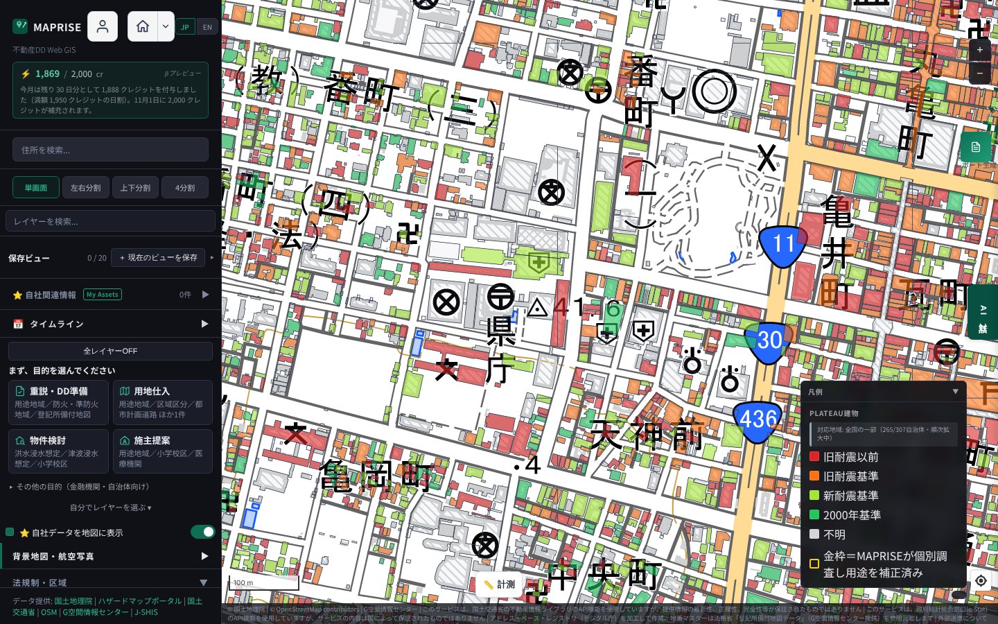
About 61% of known-year buildings date from 1981 or earlier (75% had a year). Unlike the other four, all four colours are mixed.
History. In the early hours of 4 July 1945, an air raid killed 1,359 people in Takamatsu and is said to have reduced about 80% of the old urban area to ashes. Large-scale land readjustment for war reconstruction followed, widening and improving streets (in Dori-machi, the replotting was publicly notified in 1964).
Reading the map. Because most of the city was lost, today's buildings are mostly postwar. The mix of colours is probably the result of generations of rebuilding from the 1960s to the 1980s and after. Where the other four are "towns where old buildings remained", Takamatsu looks like "a town cleared once, then rebuilt generation upon generation".
The five areas side by side
| Area | Share built 1981 or earlier (known years) | Coverage | Background |
|---|---|---|---|
| Mojiko | ~75% | ~79% | Continental trade port; postwar decline in demand |
| Kanazawa, Higashi Chaya area | ~74% | ~71% | Edo-period tea-house town; preservation district |
| Wakamatsu | ~71% | ~79% | Coal shipping port; shift to industry |
| Takamatsu, city centre | ~61% | ~75% | Post-air-raid reconstruction; generational rebuilding |
| Kyoto Nishijin | ~51% | ~86% | Craftsmen's quarter since the Onin War; machiya |
(Counted over the captured screen's buildings with a known year; as displayed in MAPRISE in October 2026.)
What they share is that a high share of pre-1981 buildings directly reflects the history of the land: a port town where a prosperous era's streetscape remained, a preserved historic district, a craftsmen's alley quarter, and reconstruction-era buildings. The colour is the same, but the background differs in each.
Why read it alongside land history
Land-history research in real-estate due diligence checks a site's past use and disaster record. The seismic-standard colouring adds the viewpoint of the building stock's generation.
- Real-estate transactions: neighbouring building generations and the area's origins become material for explanation.
- Financial institutions: the generations of buildings across a collateral area can inform risk assessment.
- Local governments: a basis for prioritising areas for seismic retrofitting.
Grasp the overall pattern on the map, click a building of interest, and, when needed, go on to the AI's six-scenario collapse-probability analysis.
Closing
We introduced five areas, but PLATEAU coverage is expanding nationwide and areas with construction-year data are likely to grow. Please look at your own area, or the site you are researching, on the MAPRISE map.
PLATEAU building data is based on the 3D city model developed by MLIT. Seismic-standard classes are reference information derived mechanically from construction years and do not guarantee the seismic performance of any building. Always consult an architect or other professional about the need for seismic assessment or retrofitting.
External sources consulted
- Arakawa City document (aims of the new standard; Hanshin-Awaji damage): https://www.city.arakawa.tokyo.jp/documents/44219/202603keikaku.pdf
- Yao City document (damage to buildings under the new standard): https://www.city.yao.osaka.jp/_res/projects/default_project/_page_/001/009/661/r8taisokukeikakusiryou.pdf
- Moji Customs history (special export port): https://www.customs.go.jp/moji/moji_history/moji_history.html
- MLIT Kyushu Regional Development Bureau, Kitakyushu Port and Airport Office, "West Coast / Mojiko Retro District" (grand opening in 1995; Japanese): https://www.pa.qsr.mlit.go.jp/kitakyusyu/port/mojikou/index.html
- Kitakyushu City, Dokai Bay and Wakamatsu history: https://www.city.kitakyushu.lg.jp/contents/924_10252.html
- MLIT historic townscape document (Higashi Chaya): https://www.mlit.go.jp/toshi/rekimachi/content/001578362.pdf
- Kanazawa's three tea-house districts (nippon.com): https://www.nippon.com/ja/japan-video/vi001002/
- Nishijin (Kotobank): https://kotobank.jp/word/%E8%A5%BF%E9%99%A3-109453
- Kyoto City document (machiya): https://www.city.kyoto.lg.jp/templates/shingikai_kekka/cmsfiles/contents/0000235/235215/03_shiryou3.pdf
- Takamatsu City Peace Memorial newsletter: https://www.city.takamatsu.kagawa.jp/kurashi/shinotorikumi/jinken/keihatsu/heiwa/dayori.files/dayori96.pdf
- KSB report on the Takamatsu air raid: https://news.ksb.co.jp/article/16889260
Tags: #PLATEAU #Seismic standards #Pre-1981 buildings #Land history #Due diligence #3D city model
Other-language share text (exception cases)
Quick share above follows our platform-locked language policy (X-family in Japanese, LinkedIn in English). The four panes below let you grab the opposite-language body when needed — e.g. introducing an English post to a Japanese audience on X, or posting a Japanese article to LinkedIn in Japanese. Each pane offers both a copy button and a direct intent link.
📝 旧耐震の建物が多い街には、理由がある ― PLATEAUの耐震基準マップで巡る全国5地域と土地の歴史
PLATEAUの建築年から耐震基準世代を色分けできるMAPRISEの地図で、旧耐震(1981年以前)の建物が目立つ全国5地域(門司港・若松・金沢東山・京都西陣・高松)を実際にキャプチャし、その土地の歴史と重ねて読み解きます。地図の色は、街の来歴の写し絵でもあります。
https://maprise.jp/ja/blog/pre-1981-buildings-land-history/ #PLATEAU #耐震基準
🆕 新しいブログ記事を公開しました。

《旧耐震の建物が多い街には、理由がある ― PLATEAUの耐震基準マップで巡る全国5地域と土地の歴史》

PLATEAUの建築年から耐震基準世代を色分けできるMAPRISEの地図で、旧耐震(1981年以前)の建物が目立つ全国5地域(門司港・若松・金沢東山・京都西陣・高松)を実際にキャプチャし、その土地の歴史と重ねて読み解きます。地図の色は、街の来歴の写し絵でもあります。

👉 詳しくはこちら: https://maprise.jp/ja/blog/pre-1981-buildings-land-history/

#PLATEAU
📝 Why Some Towns Are Full of Pre-1981 Buildings — Five Japanese Areas on the PLATEAU Seismic-Standard Map, and the History of the Land
MAPRISE colours buildings by seismic-standard generation using construction years from PL…
https://maprise.jp/en/blog/pre-1981-buildings-land-history/ #PLATEAU #Seismicstandards
🆕 New on the MAPRISE blog.

《Why Some Towns Are Full of Pre-1981 Buildings — Five Japanese Areas on the PLATEAU Seismic-Standard Map, and the History of the Land》

MAPRISE colours buildings by seismic-standard generation using construction years from PLATEAU. We captured five areas across Japan where pre-1981 buildings stand out (Mojiko, Wakamatsu, Kanazawa Higashiyama, Kyoto Nishijin, Takamatsu) and read them against the history of each place.

👉 Read the full post: https://maprise.jp/en/blog/pre-1981-buildings-land-history/

#PLATEAU #Seismicstandards #Pre-1981buildings #Landhistory #Duediligence