On the night of the 1854 Ansei-Nankai earthquake, Hamaguchi Goryo led villagers to the hilltop Hiro Hachiman Shrine, and later built the Hirokawa Embankment with his own funds. It protected the village again 92 years later. We measured the embankment crest and the shrine with GSI 1 m elevation data, and reflect on what these people left behind.
Hello, this is the MAPRISE development team.
In Hirokawa, Wakayama Prefecture, an embankment built about 170 years ago still stands. It is the Hirokawa Embankment (Hiromura Teibo). It was built by Hamaguchi Goryo, the head of a local merchant family.
On the night of the Ansei-Nankai earthquake, Goryo led villagers who had been left behind in the dark to Hiro Hachiman Shrine on higher ground. Afterwards, while helping the devastated village recover, he spent his own fortune on an embankment meant for "the next tsunami, a hundred years from now."
In this article we follow that story and check, using elevation data from the Geospatial Information Authority of Japan (GSI), how much higher the shrine, the evacuation site, stands than the village below. We also ask whether what these people left us was only a structure.
Key points
- The 1854 tsunami was about 5 m high. Goryo is said to have guided villagers to the hilltop Hiro Hachiman Shrine in the dark
- The embankment he built is about 5 m high and about 600 m long. It took about four years, and villagers were hired to build it
- Measured with 1 m elevation data, the embankment crest is about 5-6 m above sea level, about as high as the 1854 tsunami (about 5 m). The shrine stands at about 13 m, roughly 10 m above the village (about 2-3 m)
- 92 years later, in the 1946 Showa-Nankai earthquake, the embankment again protected most of the village behind it
1. The night of the tsunami, 1854
In December 1854, the Ansei-Nankai earthquake struck, and a tsunami hit Hiro village (today's Hirokawa). According to the Japan Meteorological Agency (JMA), a tsunami about 5 m high overtopped the stone breakwater built in the early 15th century and flowed into the rice fields behind it, especially along the Egami and Hirokawa rivers on both sides of the village.
Goryo is said to have set fire to stacks of harvested rice (inamura) in the fields, guiding villagers who had been left behind in the dark to the grounds of Hiro Hachiman Shrine on higher ground.
Lafcadio Hearn (Koizumi Yakumo) later turned this episode into the story "A Living God", and a teaching text based on it, "Inamura no Hi", appeared in Japanese primary-school readers for about ten years from 1937.
The story and the facts differ in several ways, however. In the story, the hero is an old man living on high ground; the real Goryo was 35 and lived in a village on low ground. JMA also notes that the story says the fire was set to warn villagers of the tsunami, while in the real account it was to show drifting people where safe ground was. Reading the story and the facts separately matters if we want to pass the episode on accurately.
2. What Goryo chose to do afterwards
Goryo's contribution was not limited to that night. After the tsunami he worked on relief for the victims and on the village's recovery.
Then, to prepare for the tsunami expected a hundred years later, he spent a huge sum of his own money on an embankment about 5 m high and about 600 m long, with a belt of pine trees planted on the sea side.
The work took about four years. By hiring villagers for it, Goryo is said to have kept people from leaving the devastated village. The embankment was both a defence for lives and work that rebuilt the village's livelihood.
3. Measuring the heights
So how different are the embankment and the shrine in height? We used GSI's 1 m elevation data to draw a map with 1 m color bands. Lower ground is blue and higher ground is red.
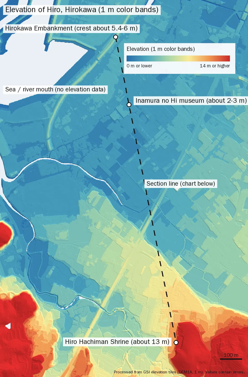
The thin yellow-green arc along the sea side is the Hirokawa Embankment. At 1 m bands it clearly stands a notch above the blue lowland (rice fields and the village). Hiro Hachiman Shrine, at lower right, lies at the foot of the yellow-to-red high ground.
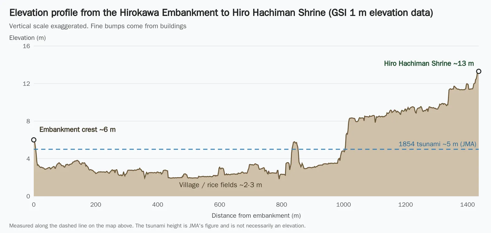
The next chart shows elevation measured along the dashed line from the embankment to the shrine.
| Place | Elevation / height | Source |
|---|---|---|
| 1854 tsunami | about 5 m high | JMA |
| Hirokawa Embankment (documents) | about 5 m high, about 600 m long | JMA |
| Embankment crest (measured) | about 5-6 m above sea level (about 10-12 m wide at half height) | GSI DEM (1 m) |
| Hiro village and rice fields (low ground) | about 2-3 m above sea level | GSI DEM (1 m) |
| Hiro Hachiman Shrine | about 13 m above sea level (hill behind it over 30 m) | GSI DEM (1 m) |
Three things stood out.
- The crest is about as high as the 1854 tsunami: the crest is about 5-6 m above sea level, close to JMA's tsunami height of about 5 m. Goryo seems to have aimed for a height that would keep the same tsunami out of the village
- The village is low: the lowland the tsunami ran across is only 2-3 m above sea level, so the crest stands about 3 m above the ground around it
- The shrine is about 10 m higher: at about 13 m, it sits well above the tsunami's height (about 5 m). From the foot of the slope up to the shrine is about 400 m, and the foot is about 1 km from the embankment
The documents say "about 5 m high", while our measurement puts the crest about 3 m above the surrounding ground. We have not confirmed why. The height when built versus the reference used to measure it, settling over the years, or raised ground around the embankment are all possibilities. Elevations contain errors and vary by point, so please read them as approximate.
Seen through MAPRISE's contour-band map (1 m bands)
We also displayed the same place in MAPRISE's "Contour Map (Color Bands)" basemap with 1 m bands (1 m and 2 m bands are a Starter-plan-and-above feature). Lower ground is blue and higher ground is red, and the color changes every 1 m. The color range is set automatically from the elevations on screen, so the legend values differ from screen to screen.
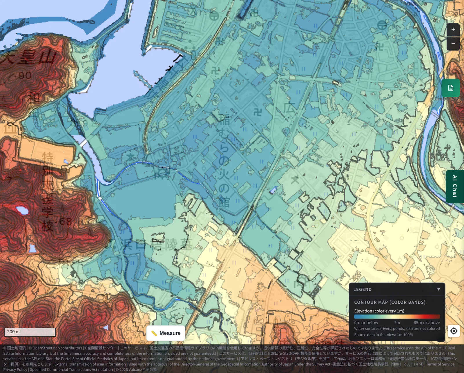
First, an overview from the embankment to the high ground. The arc from the sea side at upper left is the Hirokawa Embankment. From there, elevation rises through the blue to blue-green lowland around the Inamura no Hi museum to the yellow-to-red high ground at lower right.
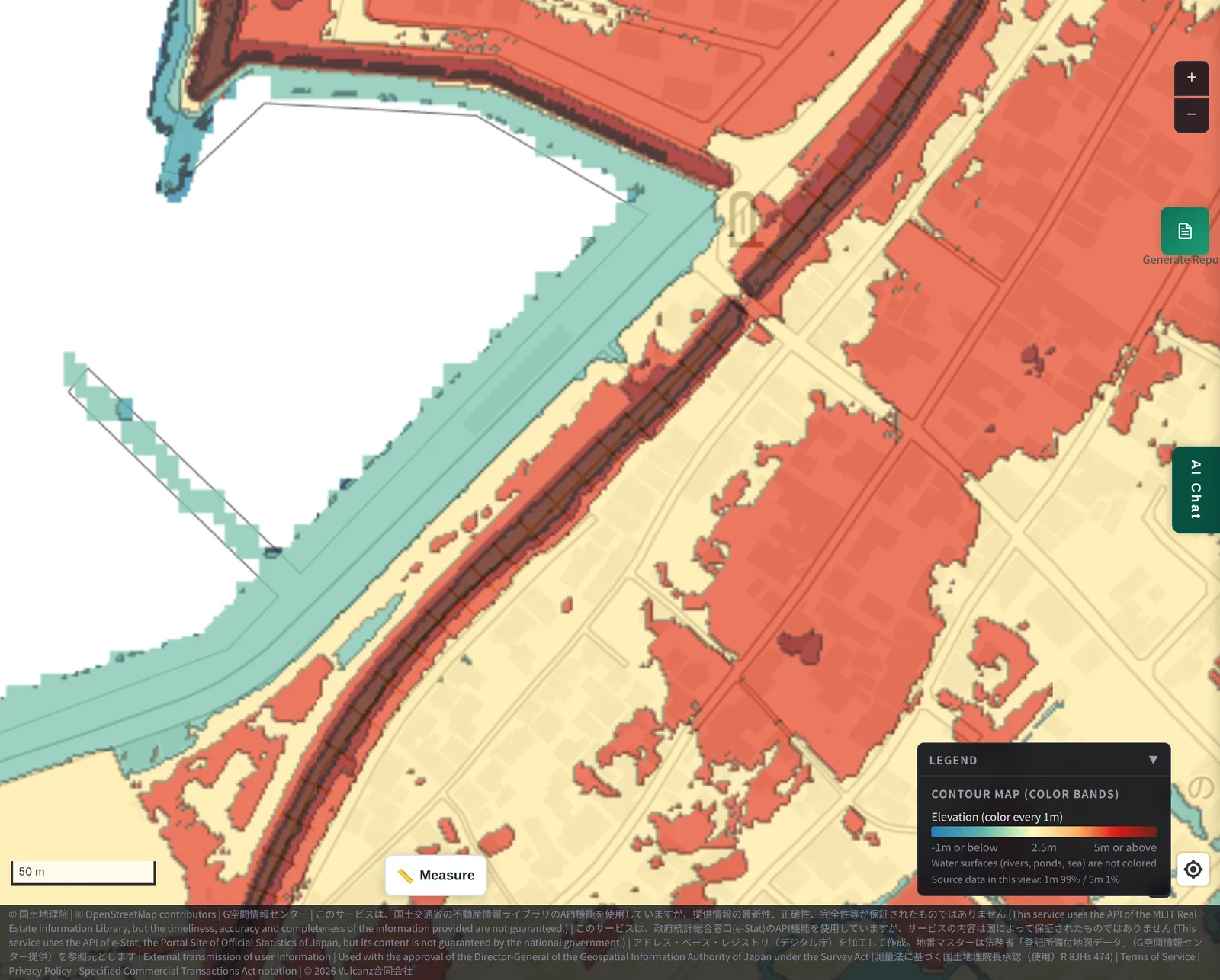
Next, a close-up of the embankment. The legend runs from "-1 m or lower" to "5 m or higher", and 5 m or higher is dark brown. The crest shows up as a thin dark brown band running unbroken between the sea side and the village, clearly one step above the surrounding ground (yellow to orange). A crest at 5 m or higher also agrees with our 1 m mesh measurement (about 5-6 m).
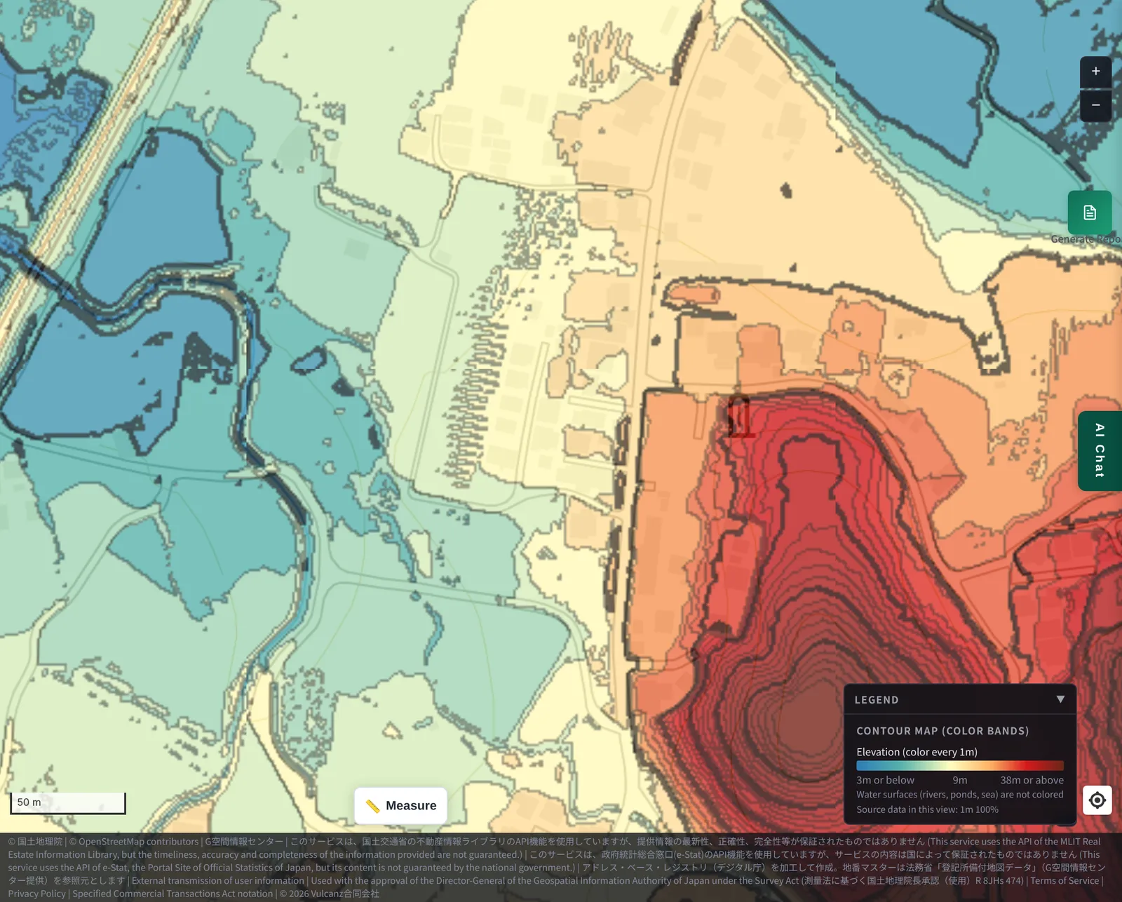
Finally, the area around Hiro Hachiman Shrine. The legend runs from "3 m or lower" to "38 m or higher". From the blue to blue-green lowland on the left, through the orange foot of the hill where the shrine stands, to the red hill behind it, 1 m bands pile up closely. The shrine sits a step above the lowland, with even higher ground behind it, as the change of color shows.
4. Ninety-two years later, the embankment held
Goryo's embankment did take on a real tsunami.
At dawn on 21 December 1946, the Showa-Nankai earthquake struck, and about 30 minutes later a tsunami 4-5 m high hit Hiro village, 92 years after the Ansei tsunami. According to JMA, the embankment protected most of the residential area behind it.
On the other hand, a junior high school and a spinning mill outside the embankment were damaged. The record also notes that the tsunami, its force concentrated by the embankment, ran up along the rivers, and many of those who were too late to evacuate died near the rice fields. An embankment does not make evacuation unnecessary, which is another important lesson these people left us.
5. What they left us was more than an embankment
In Hirokawa, people have carried this spirit forward ever since. In 1933 villagers built a gratitude monument (kan'on-hi) on the embankment, and every year students from primary and junior high schools take part in the Tsunami Festival, including repairing the embankment.
We think there are several things we can learn from Goryo and the embankment:
- Physical protection: an embankment about 5 m high protected the village from the Showa tsunami, nearly 170 years on
- A way of thinking: he chose preparation for "a hundred years from now", a benefit he might never see in his lifetime
- Protecting livelihoods: by hiring villagers he kept the devastated village from scattering
- Passing it on: the story became teaching material, and through the festival and the monument it is handed down across generations
Structures age. Yet the idea of doing what we can now to protect the lives of the next generation may only grow more valuable with time.
6. Why not check the elevation of your own town?
Measuring the shrine and the village made us feel again how important it is to know the elevation of where we live and work, and the distance to the nearest high ground.
We cannot count on someone like Goryo lighting the way in the dark. That is why checking elevation on a map in ordinary times is one of the preparations each of us can make.
What we learned, and what we could not
What we learned
- The Hirokawa Embankment is about 5 m high and about 600 m long per the documents; 1 m elevation data puts its crest at about 5-6 m above sea level, similar to the 1854 tsunami
- Hiro Hachiman Shrine (about 13 m above sea level) is about 10 m higher than Hiro village (about 2-3 m)
What we could not determine / cautions
- Elevations are GSI measurements and vary slightly by point. We have not confirmed why the documented height (about 5 m) and the measured crest (about 3 m above the surrounding ground) differ. We did not measure the sea-side stone wall or the original shape
- The story and the facts differ in places; this article follows JMA's account
- This article looks back at past events. It does not predict the height or arrival of any future tsunami
Sources
- JMA, "Inamura no Hi (Hirokawa Then and Now)": https://www.jma.go.jp/jma/kishou/books/tsunami/inamura/p2.html
- JMA, "Inamura no Hi (Hamaguchi Goryo's achievements)": https://www.jma.go.jp/jma/kishou/books/tsunami/inamura/p3.html
- JMA, "Inamura no Hi (Differences from the facts)": https://www.jma.go.jp/jma/kishou/books/tsunami/inamura/p6.html
- JMA, "Inamura no Hi (Showa-Nankai tsunami)": https://www.jma.go.jp/jma/kishou/books/tsunami/inamura/p7.html
- GSI, "Elevation tiles (DEM1A) / GSI tile list": https://maps.gsi.go.jp/development/ichiran.html
- GSI, "Elevation API": https://cyberjapandata2.gsi.go.jp/general/dem/scripts/getelevation.php
- OpenStreetMap (location of Hiro Hachiman Shrine): https://www.openstreetmap.org/
Tags: #Hamaguchi Goryo #Hirokawa Embankment #Inamura no Hi #Hiro Hachiman Shrine #Tsunami #Ansei-Nankai earthquake #Showa-Nankai earthquake #Elevation #Hirokawa #Wakayama
Other-language share text (exception cases)
Quick share above follows our platform-locked language policy (X-family in Japanese, LinkedIn in English). The four panes below let you grab the opposite-language body when needed — e.g. introducing an English post to a Japanese audience on X, or posting a Japanese article to LinkedIn in Japanese. Each pane offers both a copy button and a direct intent link.
📝 百年後の私たちを守る堤防 ― 濱口梧陵と広村堤防、そして廣八幡神社までの「約10メートル」
安政南海地震の夜、濱口梧陵は村人を高台の廣八幡神社へ導き、その後は私財を投じて広村堤防を築きました。堤防は92年後の昭和南海地震でも集落を守っています。堤防の天端と神社の標高を地理院の1m標高データで測り、先人が残してくれたものを考えました。
https://maprise.jp/ja/blog/hirokawa-hamaguchi-goryo-inamura-no-hi/ #濱口梧陵 #広村堤防
🆕 新しいブログ記事を公開しました。

《百年後の私たちを守る堤防 ― 濱口梧陵と広村堤防、そして廣八幡神社までの「約10メートル」》

安政南海地震の夜、濱口梧陵は村人を高台の廣八幡神社へ導き、その後は私財を投じて広村堤防を築きました。堤防は92年後の昭和南海地震でも集落を守っています。堤防の天端と神社の標高を地理院の1m標高データで測り、先人が残してくれたものを考えました。

👉 詳しくはこちら: https://maprise.jp/ja/blog/hirokawa-hamaguchi-goryo-inamura-no-hi/
📝 A Seawall That Still Protects Us 170 Years Later: Hamaguchi Goryo, the Hirokawa Embankment, and the 10 Metres to Hiro Hachiman Shrine
On the night of the 1854 Ansei-Nankai earthquake, Hamaguchi Goryo led villagers…
https://maprise.jp/en/blog/hirokawa-hamaguchi-goryo-inamura-no-hi/ #HamaguchiGoryo #HirokawaEmbankment
🆕 New on the MAPRISE blog.

《A Seawall That Still Protects Us 170 Years Later: Hamaguchi Goryo, the Hirokawa Embankment, and the 10 Metres to Hiro Hachiman Shrine》

On the night of the 1854 Ansei-Nankai earthquake, Hamaguchi Goryo led villagers to the hilltop Hiro Hachiman Shrine, and later built the Hirokawa Embankment with his own funds. It protected the village again 92 years later. We measured the embankment crest and the shrine with GSI 1 m elevation data, and reflect on what these people left behind.

👉 Read the full post: https://maprise.jp/en/blog/hirokawa-hamaguchi-goryo-inamura-no-hi/

#HamaguchiGoryo #HirokawaEmbankment #InamuranoHi #HiroHachimanShrine #Tsunami
Related posts
- Did the Rich Move Uphill to Avoid Floods? Testing 'Yamanote vs Shitamachi' in Tokyo, Nagoya, Osaka and Fukuoka with Four Maps2026-10-24
- Reading Chiba's Flooded Areas with MAPRISE Layers — Meiji-Era Wetlands, Geology, Elevation, and Official Hazard Maps2026-10-12
- Rivers That Flow Above the City — Ceiling Rivers (Tenjogawa) and Living Behind a Levee (Hanshin, Shiga, Nagoya, and Tokyo's Arakawa)2026-10-12