Using the Forestry Agency's National Forest GIS Data (FY2024 edition), we've added a layer that displays Kyushu's national forests at the "sub-compartment" level for all 7 prefectures — with species, stand age, area, function type, and protection-forest designation. Here's how it changes what you see, alongside the existing Forest Area layer.
Hello from the MAPRISE team. Today we're introducing two new layers: "National Forest (Sub-compartments)" and "National Forest Roads." The source is the Forestry Agency's "National Forest GIS Data (FY2024 edition)," published in December 2025. For all 7 Kyushu prefectures, you can now check species, stand age, area, function type, and protection-forest designation for each National Forest sub-compartment directly on the map.
How is this different from the existing "Forest Area" layer?
MAPRISE has long included a "Forest Area" layer sourced from National Land Numerical Information, which color-codes four categories — regional forest-plan private forest, conservation protection forest, watershed protection forest, and national forest. The national-forest portion of that layer, however, is reference-grade only, and boundary precision isn't guaranteed. If you needed the precise boundaries, area, or species composition of an actual National Forest, that layer alone wasn't enough.
The new "National Forest (Sub-compartments)" layer is a different dataset entirely. It's the Forestry Agency's own source data from the National Forest GIS system used in day-to-day forest management, divided into polygons by "sub-compartment" (小班) — a subdivision of the larger "block" (林班) unit. In the Forestry Agency's own terminology, a sub-compartment is "the smallest unit managed as a single, cohesive forest stand." National Forests are generally not available for sale or development, but when a transaction or valuation involves adjacent land, this precise boundary data becomes a genuinely useful reference point.
Seeing it on the actual map
First, an example from around Miyakonojo City, Miyazaki Prefecture. With the National Forest (Sub-compartments) layer on, clicking a parcel brings up a detail popup for that sub-compartment.
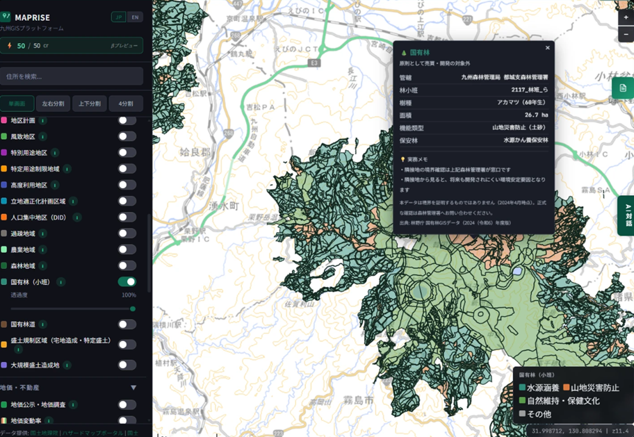
The popup lists the managing Regional Forest Office and District Forest Office, the sub-compartment's identifying name, the dominant species and its age (as of the forest plan's establishment year), the area, the emphasized function type, and any protection-forest designations. Below that, we've added a practical note: boundary confirmation for adjacent land goes through the District Forest Office, and — from a neighboring property's point of view — this can be a stabilizing factor, since future development is unlikely.
What the data around Tachibanayama, Fukuoka, shows
Here's a second example, from around Mt. Tachibana, which straddles Higashi-ku, Fukuoka City and neighboring Shingu Town. Tachibanayama is known for its old-growth camphor forest — some trees said to be over 300 years old, designated a Special Natural Monument of Japan. Clicking a sub-compartment near this area reveals an interesting data point.
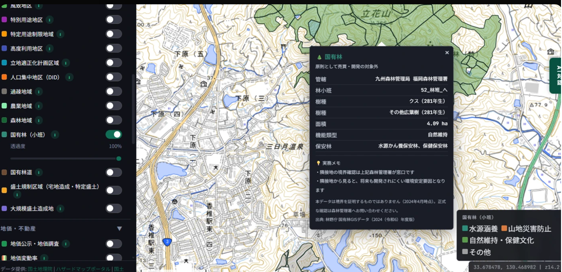
This sub-compartment records camphor ("Kusu") as its dominant species, at 281 years old. That figure sits close to the locally told story of a "300-year-old great camphor" — an interesting case of a public forest-planning record roughly corroborating local lore. Note that this figure is a sub-compartment-level aggregate (covering 4.09 ha), not a record of any single named tree. The function type here is "nature conservation," and two protection-forest designations apply — watershed conservation and health/recreation — indicating this area is managed with both water-source protection and public recreational value in mind.
Overlaying it on the Forest Area layer
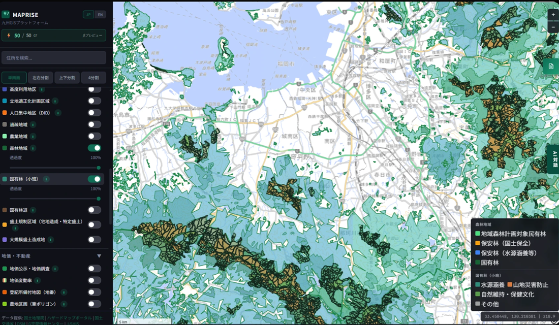
The Forest Area layer and the National Forest (Sub-compartments) layer can each be toggled independently from the left-hand menu. Overlaying both makes the difference between the reference-grade national-forest category (the dark-green fill in the Forest Area layer) and the Forestry Agency's precise boundaries (the black-outlined sub-compartment polygons) immediately visible.
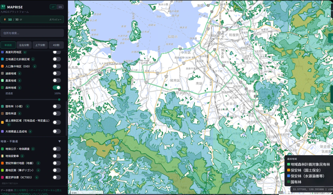
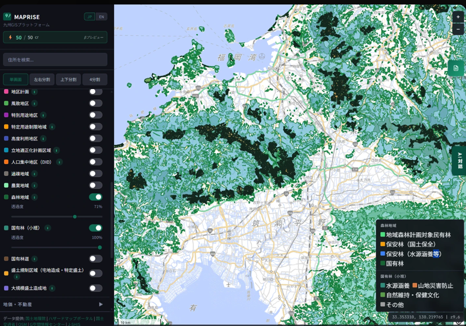
The National Forest (Sub-compartments) layer is color-coded by function type — watershed conservation, mountain disaster prevention, nature conservation / recreation, or other — rather than by area. Within the same National Forest, you can now see at a glance which sub-compartments are managed for which primary purpose. Zooming in a bit further makes this distinction even clearer.
How this helps across five industries
MAPRISE's primary target industries are real estate agencies, developers & funds, financial institutions (loan underwriting), professional services (appraisal, survey, legal), and local government (urban planning, disaster prevention). Here's how we see National Forest data helping in each:
Real estate agencies dealing with forest land or vacation properties can use this for environmental due diligence. If a target property borders National Forest land, that can be presented to clients as a factor stabilizing the surrounding environment against future development.
Developers & funds can use it to exclude parcels during initial land screening. Since National Forests are generally not available for acquisition or development, being able to identify these areas on the map early on reduces wasted site visits.
Financial institutions (loan underwriting) can use it to check adjacent-parcel risk during collateral appraisal. When a collateral property borders National Forest land, that can sometimes work in the property's favor by lowering future development risk in the surrounding area.
Professional services (appraisal, survey, legal) can use this for preliminary boundary research and environmental-factor analysis in valuations. When a target property is adjacent to National Forest land, knowing in advance that boundary confirmation goes through the District Forest Office is useful, and species/stand-age/protection-forest data can inform the description of surrounding environmental conditions in an appraisal report.
Local government (urban planning, disaster prevention) staff can get an overview of protection-forest designations (watershed conservation, erosion control, etc.) as foundational material for disaster-prevention and forest-management planning. Understanding which function type governs the National Forest land within a jurisdiction is also a useful input for understanding local water resources and disaster-prevention capacity.
A note on the data
This layer is sourced from the Forestry Agency's "National Forest GIS Data (FY2024 edition)." The underlying data may contain positional errors introduced during compilation, and the position, area, forest type, and species information for each sub-compartment may not always match on-the-ground conditions. Accordingly, it does not certify ownership, property boundaries, area, or the valuation of standing timber. The data reflects conditions as of April 2024 and does not represent the current state. Entering a National Forest generally requires prior notification to the managing Regional or District Forest Office, except in certain cases, and forest roads may not always be passable. For official boundary confirmation or entry procedures, please contact the relevant District Forest Office directly.
Source: National Forest GIS Data (FY2024 edition), Forestry Agency, PDL1.0 (Public Data License version 1.0)
Tags: #national forest #forestry #data update #land screening #collateral appraisal
Other-language share text (exception cases)
Quick share above follows our platform-locked language policy (X-family in Japanese, LinkedIn in English). The four panes below let you grab the opposite-language body when needed — e.g. introducing an English post to a Japanese audience on X, or posting a Japanese article to LinkedIn in Japanese. Each pane offers both a copy button and a direct intent link.
📝 国有林の境界を、地図の上で ― 樹種・林齢・保安林まで分かる「国有林(小班)」レイヤーを追加しました
林野庁の国有林GISデータ(2024(令和6)年度版)をもとに、九州7県の国有林を「小班」単位で表示するレイヤーを追加しました。樹種・林齢・面積・機能類型・保安林指定まで確認でき、既存の「森林地域」レイヤーとあわせて使うことで、土地の見え方がどう変わるかをご紹介します。
https://maprise.jp/ja/blog/national-forest-compartments/ #国有林 #森林
🆕 新しいブログ記事を公開しました。

《国有林の境界を、地図の上で ― 樹種・林齢・保安林まで分かる「国有林(小班)」レイヤーを追加しました》

林野庁の国有林GISデータ(2024(令和6)年度版)をもとに、九州7県の国有林を「小班」単位で表示するレイヤーを追加しました。樹種・林齢・面積・機能類型・保安林指定まで確認でき、既存の「森林地域」レイヤーとあわせて使うことで、土地の見え方がどう変わるかをご紹介します。

👉 詳しくはこちら: https://maprise.jp/ja/blog/national-forest-compartments/
📝 National Forest Boundaries, On the Map — Species, Stand Age, and Protection-Forest Status Now Visible in the New "National Forest (Sub-compartments)" Layer
Using the Forestry Agency's National Forest GIS Data (FY2024 editio…
https://maprise.jp/en/blog/national-forest-compartments/ #nationalforest #forestry
🆕 New on the MAPRISE blog.

《National Forest Boundaries, On the Map — Species, Stand Age, and Protection-Forest Status Now Visible in the New "National Forest (Sub-compartments)" Layer》

Using the Forestry Agency's National Forest GIS Data (FY2024 edition), we've added a layer that displays Kyushu's national forests at the "sub-compartment" level for all 7 prefectures — with species, stand age, area, function type, and protection-forest designation. Here's how it changes what you see, alongside the existing Forest Area layer.

👉 Read the full post: https://maprise.jp/en/blog/national-forest-compartments/

#nationalforest #forestry #dataupdate #landscreening #collateralappraisal
Related posts
- Before You Think "The Water Won't Reach Here" — Disaster Monuments as Letters From the Past2026-07-26
- Two ways of looking at "fill land" — Embankment Regulation Zones and Large-scale Fill Land, now added2026-07-04
- "What if it rained even harder?" — seeing flood risk in stages, with the Multi-stage Flood Simulation layer2026-07-04