We found an error in how the PLATEAU building layer's "structure" categories (wood, RC, SRC, steel-frame, and so on) mapped to their underlying codes, and corrected it against the official international code list. Beyond fixing the display in AI chat and PDF reports, this post covers the role MAPRISE plays on top of PLATEAU as a national initiative, plus some layer-overlay ideas we've been dreaming up by industry.
Hello from the MAPRISE development team. This is our third PLATEAU-related post, following how to use the PLATEAU building layer and filling in unknown-use buildings. This one starts with a building that showed up as "steel-frame" on the map when it was really just... unspecified non-wood construction.
That "steel-frame" building was actually "non-wood, type unspecified"
Alongside use, seismic-code era, and height, the PLATEAU building layer carries a "structure" attribute — wood, RC (reinforced concrete), SRC (steel-reinforced concrete), S (steel-frame), light-gauge steel, and so on, describing a building's primary structural material. It's not just cosmetic: it's also one of the inputs the AI uses when calculating a building's earthquake collapse probability.
While checking something unrelated internally, we noticed one building's popup read "steel-frame," but tracing the underlying code back showed it actually meant "non-wood, type unspecified." It wasn't an isolated mislabel. Digging in, we found that the entire six-category mapping table — wood, RC, SRC, S, light-gauge steel, brick/block — had drifted out of alignment with the official international code list.
The culprit: a category that doesn't actually exist
Tracing the root cause, we found that whoever built this mapping table years ago hadn't checked the official code list — they'd guessed it probably followed the categories used in a certain municipal planning survey. Specifically, they inserted a category for "fire-resistant wood construction" as the second entry, a category that doesn't actually exist in the official list, which pushed every subsequent category one slot out of place.
| Code | 601 | 602 | 603 | 604 | 605 | 606 |
|---|---|---|---|---|---|---|
| Assumed (wrong) | Wood | Fire-resistant wood | SRC | RC | S | Light-gauge steel? |
| Official code list (correct) | Wood | SRC | RC | S | Light-gauge steel | Brick / concrete block / stone |
What's interesting is that the historical distribution data had been hinting at this error the whole time. A past record noted that "fire-resistant wood" accounted for 0.2% of all buildings — an implausibly low figure for that category in Japan's actual building stock. SRC accounting for 0.2%, on the other hand, is exactly the kind of number you'd expect. The data itself had been quietly saying "this category looks wrong" for years; nobody had cross-checked it against the official list. As a map nerd, finding a contradiction like this buried in the data is genuinely one of the most thrilling parts of the job.
To make things messier, this mapping table had been implemented separately in several different places, each drifting in its own slightly different way. The same building could show up as "SRC" in AI chat and "concrete block construction" on a different screen.
Going back to the primary source and rewriting every path
So we pulled the official international building-attribute code list that Project PLATEAU is built on (the IUR code list) directly as our primary source, and rewrote every one of these mapping tables to match it exactly.
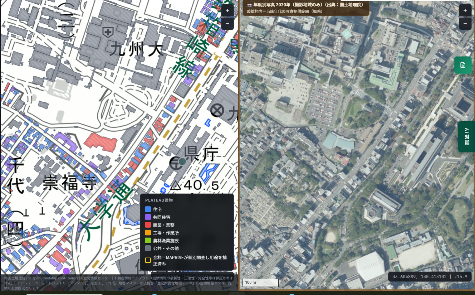
This is how we normally work — cross-checking against real aerial photography to get PLATEAU data as accurate as we can make it. For this fix, out of roughly 1.55 million PLATEAU buildings across Kyushu, about 157,000 (roughly one in ten) actually had their structure label change. We also recalculated a portion of the earthquake collapse-probability figures to match.
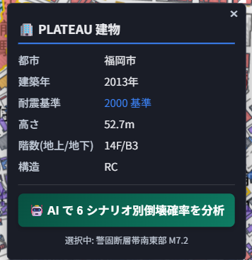
After the fix, both this "Structure: RC" display and the structure category that the "Analyze with AI" button underneath it references are now based on the correct, official code values. This wasn't just a display fix — the foundation the AI's own analysis runs on is now accurate too.

This structure filter on the left side of the map is exactly the 8 categories we corrected. Filtering to just wood-frame buildings, or just RC commercial buildings, now works against categories that actually match the official code list.
MAPRISE's role on top of a national initiative
PLATEAU is a national initiative led by Japan's Ministry of Land, Infrastructure, Transport and Tourism, and it's expected to keep being updated, refined, and expanded to new regions going forward. We see MAPRISE's job as taking this primary source data — which the national government keeps maintaining for us — and turning it into something as clear and usable as possible: visualized on a map, and screenable at a level that's actually useful for real work. This structure-code audit and correction is one small part of that ongoing job.
This structure data also feeds into our generative AI integration. Click a building and select "Analyze collapse probability across 6 scenarios with AI," and the AI runs its analysis based on that specific building's structure and construction year — a form of partial "AI-driven control" we've already built in. This fix means the structure data underpinning that analysis is now more accurate.
Overlay ideas by industry, now that the structure data is trustworthy
Accurate structure data isn't just interesting on its own — we think it gets genuinely fun once you start layering it against MAPRISE's other data. As a map nerd, here are a few ideas we've been dreaming up, imagining how each industry might actually use this.
For real-estate agents, we'd suggest overlaying structure data with boring-log (subsurface) data. A property that looks reassuring because it's "RC construction" might still sit on ground that's mostly soft, weak strata nearby — something worth mentioning to a client. It's a way to catch a risk that structure data alone can't show you.
For financial institutions doing loan underwriting, overlaying structure, seismic-code era, and multi-scale flood inundation data together seems powerful. Whether collateral is older non-wood construction under the old seismic code or newer RC under the current code changes the earthquake risk picture significantly — and layering flood data on top lets you assess two very different disaster risks side by side, on one screen.
For licensed professionals doing appraisals and surveys, we imagine overlaying structure data with official/prefectural land price survey points. Cost-approach appraisal methods start from a building's structural category as a given, so seeing structure distribution alongside surrounding land-price trends could serve as primary-source backing for how you characterize an area's overall asset composition.
For developers, overlaying structure, height, and zoning data seems like a natural fit. An area dense with old-seismic-code, low-rise wood construction, sitting in a zone where much taller buildings are actually permitted — that's exactly the kind of area-wide redevelopment-potential signal a developer would want to screen for.
For municipal staff working on urban planning and disaster prevention, we thought about overlaying structure, seismic-code era, and future population projections. Areas dense with old-seismic-code, non-wood buildings where the projected population isn't expected to decline much — meaning plenty of people are likely to keep living there — seem like exactly the places that should be prioritized for seismic retrofitting outreach. With limited budgets, that's the kind of signal that helps decide where to start.
Some of these are still just ideas at this stage, but none of them mean much without accurate underlying data as the foundation — which is exactly what made this fix worth doing. Spending time imagining how different combinations of big open data might come together on a map is, honestly, one of the more enjoyable parts of building this. If any of it ends up genuinely useful in someone's real work, that's about as good as it gets.
We'll keep refining this national asset that PLATEAU represents, making it as accurate and as usable as we can.
The structure category corrections described in this article are based on cross-referencing the official building-attribute code list under Japan's geospatial information standards (as used by Project PLATEAU). AI-based collapse-probability analysis is provided for reference only and does not guarantee the seismic performance of any individual building. For actual seismic assessment or retrofit decisions, please consult a licensed architect or structural engineer.
Tags: #PLATEAU #Data quality #Building structure #AI #Open data
Other-language share text (exception cases)
Quick share above follows our platform-locked language policy (X-family in Japanese, LinkedIn in English). The four panes below let you grab the opposite-language body when needed — e.g. introducing an English post to a Japanese audience on X, or posting a Japanese article to LinkedIn in Japanese. Each pane offers both a copy button and a direct intent link.
📝 その建物、本当に「鉄骨造」ですか? ― 建物構造データの精度を検証・是正しました
PLATEAU建物レイヤーが持つ「構造」区分(木造・RC・SRC・鉄骨造など)のコード対応に誤りがあることが分かり、国際標準の公式コードリストと突き合わせて是正しました。AIチャットやPDFレポートでの構造表示が正確になったのはもちろん、今回はPLATEAUという国家事業の上でMAPRISEが担う役割と、業種ごとに考えた重畳表示のアイデアもあわせてご紹介します。
https://maprise.jp/ja/blog/plateau-structure-fix/ #PLATEAU #データ品質
🆕 新しいブログ記事を公開しました。

《その建物、本当に「鉄骨造」ですか? ― 建物構造データの精度を検証・是正しました》

PLATEAU建物レイヤーが持つ「構造」区分(木造・RC・SRC・鉄骨造など)のコード対応に誤りがあることが分かり、国際標準の公式コードリストと突き合わせて是正しました。AIチャットやPDFレポートでの構造表示が正確になったのはもちろん、今回はPLATEAUという国家事業の上でMAPRISEが担う役割と、業種ごとに考えた重畳表示のアイデアもあわせてご紹介します。

👉 詳しくはこちら: https://maprise.jp/ja/blog/plateau-structure-fix/

#PLATEAU #AI
📝 Is that building really "steel-frame"? We audited and corrected our building structure data
We found an error in how the PLATEAU building layer's "structure" categories (wood, RC, SRC, steel-frame, and so on) mapped to their un…
https://maprise.jp/en/blog/plateau-structure-fix/ #PLATEAU #Dataquality
🆕 New on the MAPRISE blog.

《Is that building really "steel-frame"? We audited and corrected our building structure data》

We found an error in how the PLATEAU building layer's "structure" categories (wood, RC, SRC, steel-frame, and so on) mapped to their underlying codes, and corrected it against the official international code list. Beyond fixing the display in AI chat and PDF reports, this post covers the role MAPRISE plays on top of PLATEAU as a national initiative, plus some layer-overlay ideas we've been dreaming up by industry.

👉 Read the full post: https://maprise.jp/en/blog/plateau-structure-fix/

#PLATEAU #Dataquality #Buildingstructure #AI #Opendata