After its defeat at the Battle of Baekgang, ancient Japan built a massive earthen rampart called "Mizuki" to defend Dazaifu. Line up a standard map, aerial photo, elevation-tint map, and hillshade map side by side in a four-way split, and the same dead-straight artificial ridge jumps out at you in all four. A map nerd digs history out of terrain and can't stop grinning about it.
Hello from the MAPRISE development team. Today let's start with a purely personal confession: I'm a map nerd. The reason is simple — I think a map is packed full of history, if you know how to look. This time, while poking around Kyushu's terrain, I stumbled onto something genuinely fun again: Mizuki (literally "water castle").
663 AD: Dazaifu becomes the front line
Quick history recap first. In 663, the Yamato state (ancient Japan) sent a force to Korea to help its ally Baekje, and suffered a crushing defeat against the combined Tang–Silla fleet at the Battle of Baekgang. The shock of that loss was enormous — suddenly, "they might invade the home islands next" became a very real fear.
The front line for that fear was Dazaifu, in Kyushu. It was both the diplomatic gateway for receiving envoys from the continent and a critical defensive stronghold. So in 664, the very next year, Yamato built a massive earthen rampart called Mizuki, sealing off the plain around Dazaifu. The year after that, 665, they built the mountain fortress Onojo on Mt. Oki to the north and Kiijo on Mt. Kii to the south. It was around this same time that the sakimori — border-guard conscripts — system was established. In other words, the Dazaifu area was, at the time, Japan's most advanced national-defense installation.
The idea: a "great wall" built for a chokepoint, using the terrain itself
What makes Mizuki interesting is that it wasn't just a wall dropped onto flat ground. The Dazaifu basin is ringed by mountains, and the approach from Hakata Bay naturally narrows into a chokepoint. Right at that narrowest point, they built a dead-straight earthen rampart running east–west, sealing it completely. It's an idea very much in the spirit of the Great Wall of China — squeezing maximum advantage out of the terrain itself.
Splitting the screen four ways, the same straight line showed up four times
Here's where it gets good. Using MAPRISE's four-way split view, I lined up the same location as a standard map, an aerial photo, an elevation-tint map, and a hillshade map, side by side.
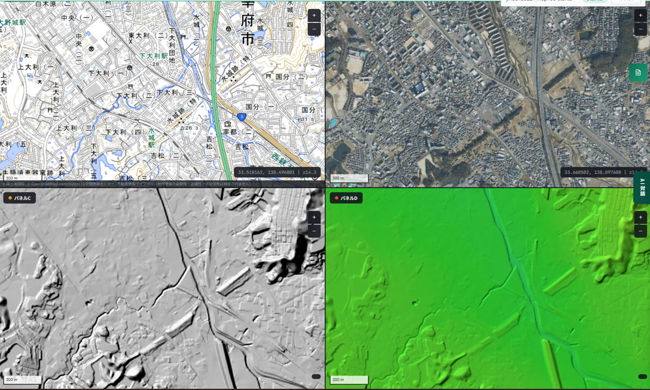
Look at that straight line. It shows up in all four panels, at the exact same angle, in the exact same spot. On the standard map you can tell from how tightly the contour lines bunch up; on the aerial photo it's a band of green; on the hillshade map it's a contrast of light and shadow; on the elevation-tint map it's a brighter streak against its surroundings. The same piece of terrain tells you "there's something here" in a different way every time you change the tool you're looking through it with. Honestly, that's the most fun part of this whole hobby.
Obviously, the people who built this had none of today's surveying technology. And yet, relying purely on the terrain they could walk and feel with their own feet, they picked out the spot that was hardest to attack and easiest to defend, and built this single straight rampart there. Just looking at the elevation difference, you can tell instantly that this isn't a natural feature — it's clearly artificial. They probably weren't holding a topographic map while building the castle, but the end result — reading terrain this precisely — feels startlingly close to what we're trying to do with MAPRISE today. I got a little more excited about that than I probably should have.
Even modern infrastructure politely detours around (or rather, through) Mizuki
Another thing I noticed: the Kyushu Expressway. The road running diagonally across the middle of the photo appears to dip — the embankment looks noticeably lower — right where it crosses the Mizuki line. There's something genuinely romantic about a 1,300-year-old earthwork still shaping the design of a modern expressway (though, of course, that's also very likely a deliberate accommodation for preserving the historic site).
Look closely at the four-panel view again, and you'll also notice a river running roughly alongside the Mizuki line. As the "water" in its name suggests, this rampart is believed to have functioned not just as a wall, but also as a dam holding back water. Terrain, river systems, and historic sites, all tied together on a single map — that's the moment this really clicked for me.
Layer on a flood hazard map, and Mizuki's "weak point" comes into view
While I was at it, I overlaid MAPRISE's flood simulation layer on the same spot.
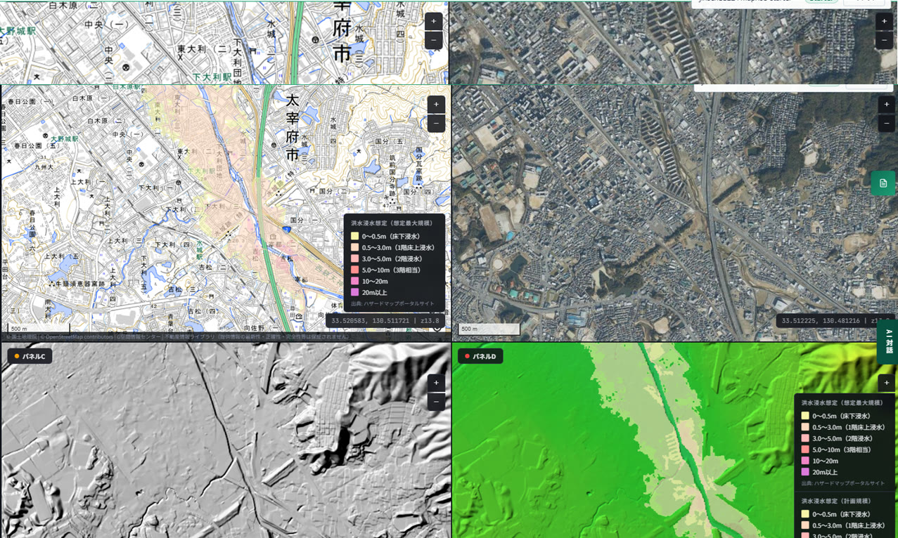
On the Hakata side of Mizuki — the side the river flows in from — you can clearly see a band of flood-extent area. Which makes sense, when you think about it: the chokepoint that Mizuki sealed off is also, by definition, low-lying land where water collects. The same terrain that made this spot militarily easy to defend also makes it a weak point for flooding today — two sides of the same coin. There's something quite moving about watching an ancient defensive stronghold surface as a meaningful point on a modern disaster-risk map, too.
A side note: the east side of Mizuki quietly became a hillside residential neighborhood
As an aside — look closely at the plateau on the east side of Mizuki (toward Onojo City), and you'll see it's been developed into a neatly subdivided residential area. Elevated, well-drained plateaus seem to get chosen for the same reasons whether you're building a defensive stronghold in the 7th century or a housing development today.
One more thing: look closely at the aerial photo, and you'll notice a single distinct green line running right along the top of the Mizuki rampart. Probably a row of cherry trees (or something similar) planted in a later era — but now the "vegetation" layer is tracing the exact outline of this historic earthwork all over again. Finding terrain, historic site, and vegetation all drawing the exact same line, three layers deep, made me grin a little more than I'd like to admit.
Zoom all the way out, and you can see exactly why Dazaifu sits where it does
Finally, let's zoom all the way out.
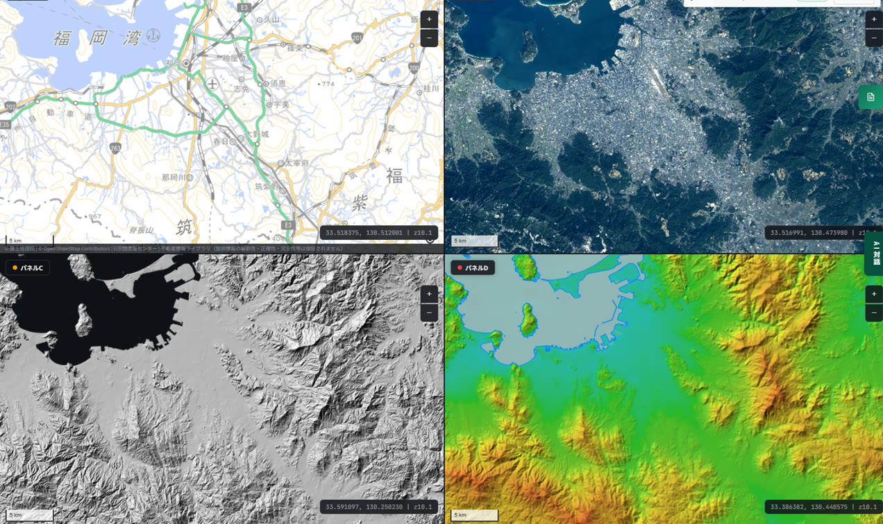
A basin just a bit inland from Hakata Bay, ringed all the way around by mountains. That's Dazaifu. Open enough to comfortably receive envoys arriving from overseas, yet defensible with mountains and Mizuki the moment an invasion threatened. Just from this one view, "why Dazaifu was placed exactly here" and "what defenses were positioned where" both snap into place — you can practically feel the reasoning of the people who made that call thirteen centuries ago.
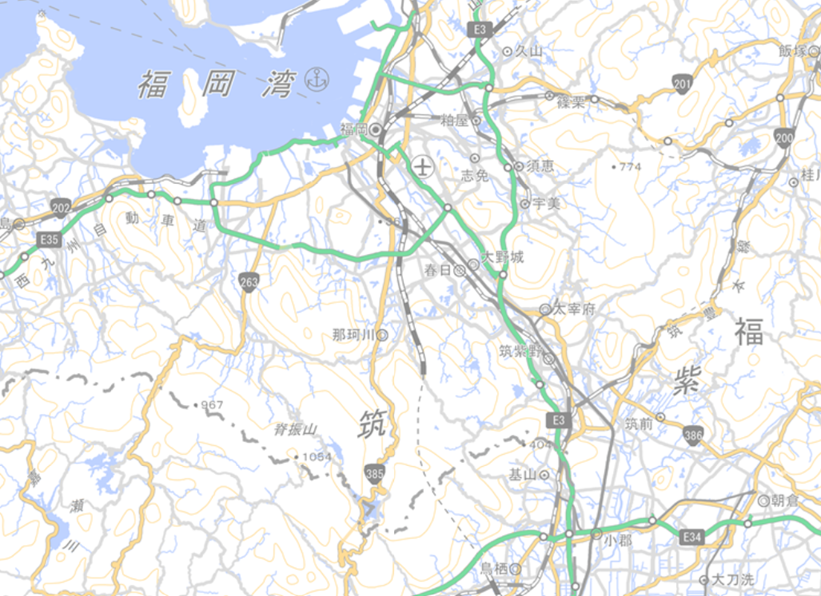
A standard map, an aerial photo, an elevation-tint map, a hillshade map. Just looking at the same place through completely different tools, and the reasoning behind a 1,300-year-old decision clicks into place, piece by piece, like a puzzle. That feeling is exactly why I can't quit maps. If you enjoyed this, chasing the Hizen Moat sleeping beneath Tenjin is cut from the same cloth. If I stumble onto another interesting bit of terrain somewhere, I'll be back to report it.
The historical account of Mizuki, Onojo, and Dazaifu in this article is a general explanation based on various publicly available sources. For the precise extent and preservation status of these historic sites, please refer to materials published by Dazaifu City, Onojo City, and related authorities. The flood simulation shown is for reference only — for actual disaster-preparedness decisions, please also check the hazard maps published by your local municipality.
Tags: #Mizuki #Dazaifu #Onojo Castle #Terrain #Hillshade map
Other-language share text (exception cases)
Quick share above follows our platform-locked language policy (X-family in Japanese, LinkedIn in English). The four panes below let you grab the opposite-language body when needed — e.g. introducing an English post to a Japanese audience on X, or posting a Japanese article to LinkedIn in Japanese. Each pane offers both a copy button and a direct intent link.
📝 大宰府をまもるための日本版の長城、こと「水城」を地図でめぐってみた
白村江の戦いに敗れた古代日本が、大宰府を守るために築いた土塁「水城」。通常地図・航空写真・色別標高図・陰影起伏図を4分割表示してみたら、まっすぐな人工の高まりが4画面すべてにくっきり浮かび上がりました。地図オタクが地形から歴史を掘り当てて、勝手にテンションが上がった記録です。
https://maprise.jp/ja/blog/mizuki-great-wall/ #水城 #大宰府
🆕 新しいブログ記事を公開しました。

《大宰府をまもるための日本版の長城、こと「水城」を地図でめぐってみた》

白村江の戦いに敗れた古代日本が、大宰府を守るために築いた土塁「水城」。通常地図・航空写真・色別標高図・陰影起伏図を4分割表示してみたら、まっすぐな人工の高まりが4画面すべてにくっきり浮かび上がりました。地図オタクが地形から歴史を掘り当てて、勝手にテンションが上がった記録です。

👉 詳しくはこちら: https://maprise.jp/ja/blog/mizuki-great-wall/
📝 Japan's own "Great Wall" for defending Dazaifu — chasing the Mizuki earthwork across the map
After its defeat at the Battle of Baekgang, ancient Japan built a massive earthen rampart called "Mizuki" to defend Dazaifu. Line up a stan…
https://maprise.jp/en/blog/mizuki-great-wall/ #Mizuki #Dazaifu
🆕 New on the MAPRISE blog.

《Japan's own "Great Wall" for defending Dazaifu — chasing the Mizuki earthwork across the map》

After its defeat at the Battle of Baekgang, ancient Japan built a massive earthen rampart called "Mizuki" to defend Dazaifu. Line up a standard map, aerial photo, elevation-tint map, and hillshade map side by side in a four-way split, and the same dead-straight artificial ridge jumps out at you in all four. A map nerd digs history out of terrain and can't stop grinning about it.

👉 Read the full post: https://maprise.jp/en/blog/mizuki-great-wall/

#Mizuki #Dazaifu #OnojoCastle #Terrain #Hillshademap